
Wakakusa, Yamanashi
Wakakusa (若草町)is an area located within greater Minami-Alps City in Yamanashi, Japan. As of 2003 it has a population of 11,671.
Geography
Wakakusa is located approximately 12 kilometers from Kofu. It covers an area of 10.29 square kilometers and lies on latitude 35 degrees North and longitude 138 degrees East. Wakakusa is a relatively flat area with many rice fields and orchards. The Kamanashi River (釜無川)forms its Eastern boundry.
History
Wakakusa contains seven hamlets:
- Toda (籐田)
- Kagaminakajo (鏡中條)
- Tōkaichiba (十嘉市場)
- Shimoimie
- Asabara
Education
Wakakusa contains four schools:
- Wakakusa Elementary School (若草小学校)
- South Wakakusa Elementary School (若草南小学校)
- Wakakusa Junior High School (若草中学校)
- Brazilian International School
Temples
- Hōzenji Temple- Founded in 806 A.D., this temple follows the Nichiren sect of Japanese Buddhism.
- Anyoji Temple- This temple follows the Shingon sect of Buddhism. It was founded in 1234 A.D.
Hot Springs
- Yu-Yu Furei Park is located in east-central Wakakusa. In addition to a large municipal park the area also contains a Hot Spring (おんせん).
Festivals
- Tokaichi festival is the most famous festival in Wakakusa. It occurs every year on 10 February. The name "Tokaichi" is taken from the Japanese word for the "tenth" day of the month-"tokka" . This festival has a history spanning five hundred years. Tens of thousands of people gather from all over Japan to celebrate the coming of spring.
-
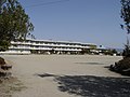 Wakakusa Elementary School
 -
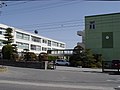 Wakakusa Junior High School
 -
 Tree Blossom
 -
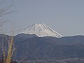 View of Mt. Fuji in Wakakusa
 -
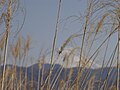 Wild Grass with Mt. Fuji in the background


| Core city | ||
|---|---|---|
| Cities | ||
| Districts | ||
| Former Districts | ||
This article about a location in Yamanashi Prefecture is a stub. You can help Wikipedia by expanding it. |