Alatsinainy Ambazaha
Appearance
Alatsinainy Ambazaha | |
|---|---|
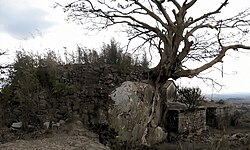
 Sacred stones at Ivatobe Avaratra, a Fokontany of this municipality | |
| Coordinates: 18°58′30″S 47°27′40″E / 18.97500°S 47.46111°E | |
| Country | |
| Region | Analamanga |
| District | Antananarivo-Atsimondrano |
| Government | |
| • Mayor | RAKOTONDRIAKA Vavaka Andrianorosoa |
| Area | |
| • Total | 18 km2 (7 sq mi) |
| Elevation | 1,259 m (4,131 ft) |
| Population (2019)Census | |
| • Total | 5,664 |
| Time zone | UTC3 (EAT) |
| postal code | 102 |
Alatsinainy Ambazaha is a rural municipality in Analamanga Region, in the Central Highlands of Madagascar. It belongs to the district of Antananarivo-Atsimondrano and its populations numbers to 5,664 in 2019.[2]
It is situated at 16 km in the South-West of the capital Antananrivo and constituted by the villages (fokontany) of : Ambohimahamanina, Morombato, Anjanamanoro, Isoatsimeloka and Ivatobe.
Agriculture
[edit]70% of the population are farmers. Rice, manioc, sweet potatoes, beans, tomatoes and potatoes are the most grown agricultural products.
Wikimedia Commons has media related to Alatsinainy Ambazaha.
References
[edit]- ^ DECENTRALISATION et DE LA GESTION TERRITORIALE DANS LA COMMUNE RURALE D’ALATSINAINY AMBAZAHA, REGION ANALAMANGA
- ^ RECENSEMENT GÉNÉRAL DE LA POPULATION ET DE L’HABITATION DE 2019 DE MADAGASCAR


