
Yeronga, Queensland
| Yeronga Brisbane, Queensland | |||||||||||||||
|---|---|---|---|---|---|---|---|---|---|---|---|---|---|---|---|
 Brisbane Corso Reserve of Yeronga | |||||||||||||||
| Population | 5,463 (2004) [1] | ||||||||||||||
| • Density | Lua error: Unable to convert population "5463 (2004) '"`UNIQ--ref-00000000-QINU`"'" to a number. | ||||||||||||||
| Postcode(s) | 4104 | ||||||||||||||
| Area | 3 km2 (1.2 sq mi) | ||||||||||||||
| Location | 7 km (4 mi) from Brisbane | ||||||||||||||
| LGA(s) | Brisbane City Council, Dutton Park Ward | ||||||||||||||
| State electorate(s) | Yeerongpilly | ||||||||||||||
| Federal division(s) | Moreton | ||||||||||||||
| |||||||||||||||
Yeronga is a suburb of Brisbane, Australia located on the Brisbane River 7 km south of the Brisbane CBD. Yeronga is a residential suburb.
Geography
Template:Mapit-AUS-suburbscale
Transport
There is a Yeronga train station on the line to Beenleigh.
Attractions
Yeronga is conveniently located nearby many educational institutions, located next to the Yeronga Institute of TAFE, and only a CityCat or ferry ride across the river to the University of Queensland at St Lucia.
References
- ^ ABS Statistics
- ^ Yeronga, accessed 27 November 2006
Gallery
-
 One of the most coveted addresses in Brisbane, the Brisbane Corso neighborhood on the waterfront
 -
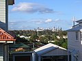 View of Brisbane CBD from Kadumba Street


External Links
This article about a place in Brisbane is a stub. You can help Wikipedia by expanding it. |