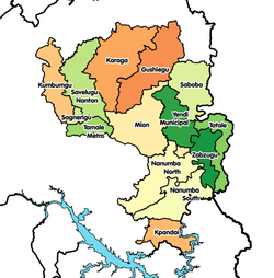
Tatale-Sangule District
Appearance
Tatale-Sangule District | |
|---|---|
 Districts of Northern Region | |
Location of Tatale-Sangule District within Northern | |
| Coordinates: 9°21′1.08″N 0°31′15.96″E / 9.3503000°N 0.5211000°E | |
| Country | |
| Region | Northern |
| Capital | Tatale |
| Population (2021) | |
| • Total | 74,805[1] |
| Time zone | UTC+0 (GMT) |
| ISO 3166 code | GH-NP-TS |
Tatale-Sangule District is one of the sixteen districts in the Northern Region of Ghana.[2][3][4] It was originally part of the then-larger Zabzugu-Tatale District in 1988, which was created from the former East Dagomba District Council. The northeast part of the district was then split off to create Tatale-Sangule District on 28 June 2012; As a consequence the remaining part was renamed as Zabzugu District. The district assembly is located in the eastern part of Northern Region whose capital town is Tatale.
References
[edit]- ^ Ghana: Administrative Division
- ^ "People in Sangule District commend government". Vibeghana. 14 October 2014. Retrieved April 10, 2015.
- ^ "Northern » Tatale Sangule (New)". ghanadistricts.com. Retrieved April 10, 2015.
- ^ Duodu, Samuel (2 March 2015). "Negative reportage scares away investors". Tatale. Retrieved April 10, 2015.

