Jump to content

Osburg

Coordinates: 49°42′53″N 6°47′34″E / 49.71472°N 6.79278°E / 49.71472; 6.79278
From Wikipedia, the free encyclopedia

This is an old revision of this page, as edited by Finlay McWalter (talk | contribs) at 14:53, 31 July 2023 (WP:SECTIONORDER). The present address (URL) is a permanent link to this revision, which may differ significantly from the current revision.

Osburg
Coat of arms of Osburg
Location of Osburg within Trier-Saarburg district
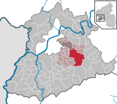
LuxembourgSaarlandBitburg-PrümBirkenfeld (district)TrierBescheidBeurenDamflosGeisfeldGrimburgGusenburgHermeskeilHinzert-PölertNaurath (Wald)NeuhüttenRascheidReinsfeldZüschBaldringenGreimerathHeddertHenternKell am SeeLampadenMandernPaschelSchillingenSchömerichVierherrenbornWaldweilerZerfKanzemKonzNittelOberbilligOnsdorfPellingenTawernTemmelsWasserlieschWawernWellenWiltingenBonerathFarschweilerGusterathGutweilerHerlHinzenburgHolzerathKaselKorlingenLorscheidMertesdorfMorscheidOllmuthOsburgPluwigRiverisSchöndorfSommerauThommWaldrachAylFischFreudenburgIrschKastel-StaadtKirfMannebachMerzkirchenOckfenPalzemSaarburgSchodenSerrigTaben-RodtTrassemWincheringenBekondDetzemEnschFellFöhrenKennKlüsserathKöwerichLeiwenLongenLonguichMehringNaurath (Eifel)PölichRiolSchleichSchweichThörnichTrittenheimAachFranzenheimHockweilerIgelKordelLangsurNewelRalingenTrierweilerWelschbilligZemmer
Osburg is located in Germany
Osburg
Osburg
Osburg is located in Rhineland-Palatinate
Osburg
Osburg
Coordinates: 49°42′53″N 6°47′34″E / 49.71472°N 6.79278°E / 49.71472; 6.79278
CountryGermany
StateRhineland-Palatinate
DistrictTrier-Saarburg
Municipal assoc.Ruwer
Area
 • Total33.92 km2 (13.10 sq mi)
Elevation
456 m (1,496 ft)
Population
 (2022-12-31)[1]
 • Total2,355
 • Density69/km2 (180/sq mi)
Time zoneUTC+01:00 (CET)
 • Summer (DST)UTC+02:00 (CEST)
Postal codes
54317
Dialling codes06500
Vehicle registrationTR

Osburg (German pronunciation: [ˈoːsbʊʁk]) is a municipality in the Trier-Saarburg district, in Rhineland-Palatinate, Germany, near Trier. The elevation of the built up area lies between 437 and 500 m, and the lowest and highest points of the municipality are 239 and 708 m.

References

  1. ^ "Bevölkerungsstand 2022, Kreise, Gemeinden, Verbandsgemeinden" (PDF) (in German). Statistisches Landesamt Rheinland-Pfalz. 2023.