Jump to content

Chamoling

Coordinates: 31°22′N 96°22′E / 31.367°N 96.367°E / 31.367; 96.367
From Wikipedia, the free encyclopedia

This is the current revision of this page, as edited by Asdfghjohnkl (talk | contribs) at 16:18, 30 September 2023 (→‎top: => Chinese language template(s)/English fixes). The present address (URL) is a permanent link to this version.

(diff) ← Previous revision | Latest revision (diff) | Newer revision → (diff)

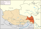
Chamoling (Tibetan: ཁྲ་མོ་གླིང་, Chinese: 长毛岭; pinyin: Chángmáolǐng) is a township in Riwoqê County, Tibet Autonomous Region of China.[1] It lies at an altitude of 4,651 metres (15,262 feet).

See also

[edit]

31°22′N 96°22′E / 31.367°N 96.367°E / 31.367; 96.367

Notes

[edit]
  1. ^ (in Chinese) Wu Zhenhua (武振华), Xizang Diming (西藏地名; Place Names in Tibet), p.67, Chinese Zangxue Press (中国藏学出版社) 1996, ISBN 7-80057-284-6