Hurricane Erika (1997)
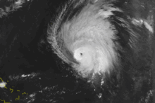
 Erika to the north of the Lesser Antilles on September 9 | |
| Meteorological history | |
|---|---|
| Formed | September 3, 1997 |
| Extratropical | September 14, 1997 |
| Dissipated | September 20, 1997 |
| Category 3 major hurricane | |
| 1-minute sustained (SSHWS/NWS) | |
| Highest winds | 125 mph (205 km/h) |
| Lowest pressure | 946 mbar (hPa); 27.94 inHg |
| Overall effects | |
| Fatalities | 2 direct |
| Damage | $10 million (1997 USD) |
| Areas affected | Leeward Islands, Puerto Rico, Azores |
| IBTrACS | |
Part of the 1997 Atlantic hurricane season | |
Hurricane Erika was the strongest and longest-lasting tropical cyclone in the 1997 Atlantic hurricane season. It developed from a tropical wave on September 3 and moved west-northwestward across the tropical Atlantic Ocean, steadily intensifying until it attained hurricane status on September 4, becoming the fifth named storm and third hurricane of the season. Erika passed a short distance to the north of the Lesser Antilles, and later turned to the north in response to an approaching trough. The hurricane quickly strengthened to become the only major hurricane of the season, reaching maximum sustained winds of 125 mph (201 km/h) on September 8; after maintaining its peak strength for 24 hours, Erika began to weaken as it passed over cooler waters. It turned to the east, weakened to a tropical storm, and became extratropical after passing near the Azores archipelago.
The hurricane produced light rainfall and winds throughout the northern Lesser Antilles. The passage of Erika carried a cloud of volcanic ash to Antigua from the eruption of the Soufrière Hills Volcano on Montserrat, a rare occurrence. Strong waves from the hurricane produced beach erosion and coastal flooding in northern Puerto Rico, and caused the death of two surfers. Moderate wind gusts in the northern Leeward Islands and Puerto Rico left thousands of residents without power, and resulted in $10 million (1997 USD, $12.6 million 2006 USD) in damage in the U.S. Caribbean territories. Erika also produced gusty winds and light rain in the Azores. Erika was the only tropical cyclone in the Atlantic Ocean in the months of August and September, the first occurrence of such event in an Atlantic hurricane season since 1929.[1]
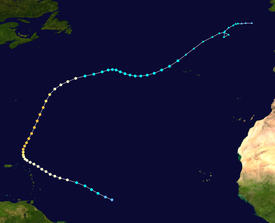
Meteorological history

Tropical storm (39–73 mph, 63–118 km/h)
Category 1 (74–95 mph, 119–153 km/h)
Category 2 (96–110 mph, 154–177 km/h)
Category 3 (111–129 mph, 178–208 km/h)
Category 4 (130–156 mph, 209–251 km/h)
Category 5 (≥157 mph, ≥252 km/h)
Unknown
A large tropical wave, which eventually became Erika, moved off the coast of Africa on August 31. Shortly after leaving the coast, it displayed a large low-level circulation, though as it tracked westward, the circulation failed to contract significantly. It slowly organized, and by September 3 the convection within the circulation had sufficiently organized for the system to be classified as Tropical Depression Six, while located about 1,150 miles (1,850 km) east of the southernmost Lesser Antilles. The depression moved west-northwestward at approximately 20 mph (32 km/h) under the influence of a well-established subtropical ridge, and late on September 3 the system intensified into a tropical storm. At that time, the National Hurricane Center in Miami gave the storm the name of Erika.[2]
Erika continued to the west-northwest, and in the early hours of September 4, an eye-like feature appeared to have developed in the center of the deep convection. The feature was not an eye, though, as visible satellite imagery revealed a center partially exposed from the convection. Despite unfavorable wind shear, Erika strengthened further and intensified into a hurricane late on September 4, while located 530 miles (850 km) east-southeast of Guadeloupe. Deep convection re-developed near the center, and the hurricane slowly strengthened as it continued west-northwestward. Hurricane Erika decelerated its forward motion as it approached the Lesser Antilles, and passed within 85 miles (137 km) of the islands as a Category 1 hurricane. An approaching trough weakened the subtropical ridge, resulting in Erika turning to the north and later to the northeast. On September 7, Erika began to quickly intensify, and the hurricane reached its peak strength of 125 mph (201 km/h) on September 8, while located about 350 miles (560 km) north of the Lesser Antilles. Erika maintained peak intensity for about 24 hours before weakening over cooler waters.[2]
After passing about 350 miles (560 km) east of Bermuda on September 10, Erika turned to the east-northeast in response to westerly steering currents. Increased upper-level wind shear weakened the hurricane to a tropical storm on September 12. Erika continued to weaken as it turned to the east-southeast, though it maintained deep convection near the center despite unfavorable atmospheric conditions. On September 14 the storm turned to the northeast again, and re-strengthened to reach winds of 70 mph (110 km/h) while located 510 miles (820 km) west-southwest of the Azores. On September 15 Erika passed near the western Azores islands, and quickly weakened as deep convection diminished. Erika became an extratropical cyclone on September 16 north of the Azores, and after executing a clockwise loop, the extratropical storm dissipated on September 19 about 230 miles (370 km) southwest of Ireland.[2]
Preparations

Early in the storm's development, forecasting Erika's motion was difficult, with a persistent leftward bias in official forecasts. In response to Erika's threat, the government of Saint Martin first issued a tropical storm warning late on September 4. The next day, the respective governments of Antigua, Montserrat, Barbuda, Saint Kitts and Nevis, Anguilla, Dominica, Guadeloupe, and Saint Barthélemy issued tropical storm warnings for their islands. When Erika's motion resulted in a path that would take it closer to the islands, all of the aforementioned islands excluding Guadeloupe upgraded the tropical storm warning to a hurricane warning. In addition, a hurricane watch was issued for the British and United States Virgin Islands, as well as Puerto Rico. In public advisories, the National Hurricane Center stated tropical storm conditions were likely to be experienced in the Azores.[2] Early forecasts anticipated a threat to the island of Bermuda.[3]
The governments of the islands in the predicted path of Erika urged residents to quickly prepare for the hurricane through radio addresses. In the wake of busy seasons in 1995 and 1996, which some islands were still recovering from, emergency preparations began.[4] In Puerto Rico, fishermen secured their boats in preparation for the storm. Also on the island, citizens formed long lines at gas stations and purchased emergency supplies. Officials in Anguilla enacted a plan that would turn off the island's power supply if the winds exceeded 50 mph (80 km/h).[5] As a precaution, authorities on Saint Martin enacted a curfew for all but those in service jobs.[6]
Impact
Hurricane Erika produced strong waves and high low-level winds throughout the Lesser Antilles. Just weeks after the eruption of the Soufrière Hills Volcano on Montserrat, the storm blew a cloud of falling ash over Antigua. Tropical storm-force winds affected several of the islands in the Lesser Antilles.[2]
Winds from Hurricane Erika peaked at 37 mph (60 km/h) with a gust of 47 mph (76 km/h) in the Cyril E. King Airport on Saint Thomas. The outer rainbands produced light to moderate rainfall in the Virgin Islands, peaking at 3.28 inches (83 mm) at the University of the Virgin Islands in Saint Thomas and 1.32 inches (34 mm) in Saint John. The precipitation produced localized street flooding, while the combination of winds and rain caused power interruptions. Offshore, strong waves capsized one dinghy and broke a 50-foot (15 m) boat from its moorings.[7] On Saint Croix, the hurricane produced sustained winds of 25 mph (40 km/h) and a peak wind gust of 29 mph (47 km/h) at the Henry E. Rohlsen Airport. Rainfall on the island was light, peaking at 0.83 inches (21 mm) at Christiansted. The wind gusts downed a few power lines, and damage was minor.[8]
The outer rainbands of Erika passed over Puerto Rico, producing maximum sustained winds of 23 mph (37 km/h) and a peak wind gust of 42 mph (68 km/h) at the Luis Muñoz Marín International Airport. The wind gusts snapped tree branches into power lines, leaving up to 12,000 people without power in San Juan, Guaynabo and Bayamón. Rainfall was light on the island, with Caguas reporting a peak total of 0.77 inches (20 mm). The hurricane produced swells of 10 to 12 ft (3.0 to 3.7 m) on the northern coast of Puerto Rico, causing beach erosion or coastal flooding. One road was closed when sections of it were flooded or washed out. The strong waves forced the evacuation of eight families in the northern portion of the island.[9] The strong waves killed two surfers in the northeastern waters of the island.[2] Damage in Puerto Rico and the U.S. Virgin Islands totaled to $10 million (1997 USD, $12.6 million 2006 USD) in a preliminary estimate.[10]
Thirty-one ships encountered Erika from September 4, when it was a tropical storm, to September 18, when it was extratropical. Two recorded hurricane-force winds, with a peak wind report of 99 mph (159 km/h). The lowest recorded pressure by a ship was 1000.4 mbar (29.542 inHg) while located 105 miles (169 km) from Erika as an extratropical storm. The lowest recorded pressure while Erika was a tropical cyclone was 1000.5 mbar (29.545 inHg) while located 190 miles (310 km) from the center. While passing near the Azores, Tropical Storm Erika produced maximum sustained winds of 30 mph (48 km/h) at Lajes Field. Gusts were much stronger, with a report of 87 mph (140 km/h) in Flores. In addition, a 200 ft (61 m) tower on Lajes recorded a gust of 105 mph (169 km/h). The storm dropped up to 2.35 inches (60 mm) of rain in Flores[2] and produced rough seas throughout the archipelago. Damage, if any, is unknown in the Azores.[10]
See also
References
- ^ Miles Lawrence (1997-10-01). "September Monthly Tropical Weather Summary". National Hurricane Center. Archived from the original (TXT) on 2012-10-25. Retrieved 2006-11-12.
- ^ a b c d e f g Miles B. Lawrence (1997-10-24). "Hurricane Erika Tropical Cyclone Report" (PDF). National Hurricane Center. Retrieved 2011-10-25.
- ^ "Hurricane Erika Swirls out over Atlantic". Reuters. 1997-09-10. Retrieved 2006-11-12.
- ^ Michelle Faul (1997-09-06). "Hurricane Erika Headed for Montserrat, Antigua". Associated Press. Retrieved 2011-10-25.
- ^ Syracuse Post-Standard (1997-09-06). "Islanders, yachters prepare for the wrath of Hurricane Erika".
- ^ Suzanne Gordon (1997-09-06). "Hurricane Erika Spares Leeward Islands So Far". Reuters. Archived from the original on 2007-09-27. Retrieved 2006-11-12.
- ^ National Climatic Data Center (1997). "Storm Events Database, St. Thomas/St. John". Retrieved 2019-07-31.
- ^ National Climatic Data Center (1997). "Storm Events Database, St. Croix". Retrieved 2019-07-31.
- ^ National Climatic Data Center (1997). "Storm Events Database, Puerto Rico". Retrieved 2006-11-11.
- ^ a b Usatoday.com (1999-06-11). "Erika swipes Caribbean, hits Azores". USA Today. Archived from the original on 2009-02-27. Retrieved 2006-11-12.

