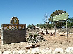
Vosburg
Appearance
This article needs additional citations for verification. (December 2009) |
Vosburg | |
|---|---|
 Vosburg | |
| Coordinates: 30°34′S 22°53′E / 30.567°S 22.883°E | |
| Country | South Africa |
| Province | Northern Cape |
| District | Pixley ka Seme |
| Municipality | Kareeberg |
| Area | |
| • Total | 65.50 km2 (25.29 sq mi) |
| Population (2011)[1] | |
| • Total | 1,259 |
| • Density | 19/km2 (50/sq mi) |
| Racial makeup (2011) | |
| • Black African | 11.8% |
| • Coloured | 79.6% |
| • Indian/Asian | 1.1% |
| • White | 7.2% |
| • Other | 0.2% |
| First languages (2011) | |
| • Afrikaans | 89.2% |
| • Xhosa | 4.5% |
| • English | 2.0% |
| • Tswana | 1.1% |
| • Other | 3.2% |
| Time zone | UTC+2 (SAST) |
| PO box | 8780 |
| Area code | 053 |
Vosburg is a town 61 km west of Britstown, in the Northern Cape province of South Africa. The town has relatively low crime rate[citation needed] and features many 19th century buildings.
Town 100 km north-north-west of Victoria West, 70 km west of Britstown and 94 km north-east of Carnarvon. It was founded in 1895 and became a municipality in 1897. Named after the Vos family, who owned the farm on which it was laid out.[2]
History
The town was established on the farm Processfontein in 1895 and was named after Mr J Vos and the Van Rensburg family.[3][4]
References
- ^ a b c d "Main Place Vosburg". Census 2011.
- ^ "Dictionary of Southern African Place Names (Public Domain)". Human Science Research Council. p. 462.
- ^ "Northern Cape - As real as the people who choose to explore it".
- ^ "Lodging - Home Page".
Wikimedia Commons has media related to Vosburg.


