
User:JimIrwin
Articles[edit]
- Delaware and Hudson Gravity Railroad - expanded the article with history section and maps
- Empire Zinc Company - created the article
- Hibernia Mine Railroad - created the article and maps
- Lehigh Valley Railroad - wrote the history section.
- Articles and maps for predecessors of the Lehigh Valley Railroad
- Moses Taylor - created the article
- National Docks Secondary - extended the history section.
- New Jersey Zinc Company - created the article
- Ogden Mine Railroad - created the article and maps
- Sparta Township, New Jersey - created the history section.
Maps[edit]
- Maps of all municipalities in New Jersey.
- Maps of national and state population density in the U.S.
- Map for the Paulinskill River article.
- Maps for the High Bridge Branch article
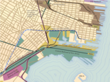
- Port of New York Railroads ca 1900 - created the map
- Historical maps for the New York, Susquehanna, & Western Railroad
- Map for the New Jersey Southern Railroad
- Map for the Delaware and Hudson Canal
- System map of the Lehigh Valley Railroad.
- Map for the Lehigh Canal
- Maps for the Delaware and Hudson Gravity Railroad
Sample map contributions
-
 Population density map of the United States.
 -
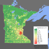 Population density maps of the individual states.
 -
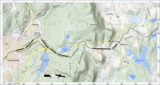
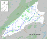 Map of the Paulins Kill river basin.
 -
 Map of the Lehigh Canal
 -
 Map of the Delaware and Hudson Canal
 -
 Map of the New York City harbor railroads in the early 20th century.
 -
 Map of the Jersey City terminal of the Lehigh Valley Railroad
 -
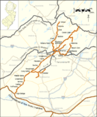 Map of the High Bridge Branch of the Central Railroad of New Jersey
 -
 Map of the historical route of the New York, Susquehanna and Western Railway
 -
 Map of the New Jersey Southern Railroad
 -
 Map of the Ogden Mine Railroad.
 -
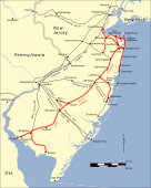
 Maps of the Delaware and Hudson Gravity Railroad.


FAQ[edit]
- How were the maps created?
- There are several kinds of maps:
- (a) maps that are located on the page of a particular township, civil subdivision of a county, or census-designated-place. See the lineage of the place and township maps.
- (b) index maps that show the boundaries of all county subdivisions. See the lineage of the county subdivision index maps.
- (c) population maps of the states. See the lineage of the state population maps.
Awards[edit]

|
The Barnstar of Peace | |
| I hereby grant you this Barnstar of Peace, for your mastery of mapping processes, and for helping us see more clearly the world in which we live. Davemcarlson 08:31, 2 October 2007 (UTC) |