Third Avenue (Brooklyn)
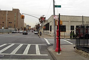
 Looking north from 3rd Street in Gowanus | |
| Owner | City of New York |
|---|---|
| Maintained by | NYCDOT |
| Length | 6.0 mi (9.7 km)[1] |
| Location | Brooklyn, New York City |
| South end | Shore Road in Bay Ridge |
| Major junctions | |
| North end | Flatbush Avenue in Downtown Brooklyn |
Third Avenue is a street in the New York City borough of Brooklyn. It runs parallel to Fourth Avenue for most of its length, and it also runs under the Gowanus Expressway from the Prospect Expressway to 65th Street. It has been mostly industrial for most of its existence, though the stretch of Third Avenue from Prospect Expressway to Downtown Brooklyn has recently undergone gentrification.[2]
The Third Avenue streetcar line formerly ran on Third Avenue from Fort Hamilton to the Brooklyn Bridge. The Fifth Avenue elevated line ran above Third Avenue in Sunset Park and Bay Ridge. The B37 bus currently runs on the street from Atlantic/Flatbush Avenues to Shore Road in Bay Ridge.
Notable structures on Third Avenue include the Coignet Building and the Somers Brothers Tinware Factory, two New York City designated landmarks at the intersection with Third Street.
References
- ^ "Third Avenue" (Map). Google Maps. Retrieved July 3, 2018.
- ^ Hawkins, Andrew J. (January 26, 2013). "Third Ave.'s revival in Brooklyn gets worrisome". Crain's New York Business. Retrieved November 19, 2022.
