Pyay
This article needs to be updated. |

Pyay (Burmese: ပ္ရည္; MLCTS: prany, formerly Prome), is a town (population 83,000 (1983)) and district of the Bago Division, Myanmar, located some 161 km (100 mi) north of Yangon. The British Irrawaddy Flotilla Company established the current town in the late 1800s on the Ayeyarwady River (Irrawaddy River) as a transshipment point for cargo between Upper Burma and Lower Burma. It is also called Pyi by the locals.
Education of Pyay
Pyay City has the 2 Universities and 1 College. Two Universities are Pyay University(PU)and Government Technological University (GTU). The college is called Government Computer College (GCC).Pyay University is situated near to the town center of Pyay. GTU is situated near to Hnawgone village, Pauk Khaung Town. It is a few miles away from Pyay. Students find it not as convenient as PU to go to GTU. GCC is also quite a far distance from downtown. (Writer By Phoe Chan-Information Technology-2002-2007) ေနာက္ပိုင္းျမန္မာလိုေရးပါမည္။(GTU)ေက်ာင္းသားေဟာင္းတဦး
The district of Pyay encompasses the valley of the Ayeyarwady, located between Thayetmyo District and Henzada and Tharrawaddy Districts. Along the western side of Pyay District are the Rakhine (Arakan) Yomas, a mountain range and along the eastern side are the Bago (Pegu) Yomas. Pyay District's main towns are Pyay, Shwedaung, and Paungde.
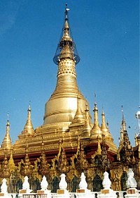
To the south and south-east the town is closed in by low pagoda-topped hills, on one of which stands the conspicuous gilded Shwesandaw Pagoda. It is the terminus of a railway from Yangon, which runs through the district.
The town is home to the Pyay University.
Etymology
The name "Pyi" means "capital" in Burmese, and refers to the ruins of the Pyu capital of Sri Ksetra (Template:Lang-my, lit. "City of Splendour" in Sanskrit), which is located 8 km to the southeast of modern Pyay and is in the village of Hmawa.
Geography and climate
The north and northeast of the district is forest-covered, and contains numerous valleys and ravines, which unite in one large stream called the Naweng River. The most important of the plains lie in the south and southwest portions of Pyay, and extend along the whole length of the railway that runs between. There are, in addition large tracts of land covered by jungle, which are available for cultivation. The principal river is the Irrawaddy, which intersects the district from north to south; next in importance are the Thani and its tributaries and the Naweng system of rivers. In the hills near the capital the soil is of Tertiary formation, and in the plains it is an alluvial deposit.
The climate is much drier than other districts in Lower Burma, the annual rainfall being about 48 in. The temperature ranges from about 100 in June to 60 in January.

History
Sri Ksetra was built around 638 AD and was the capital of the Pyu dynasty of Vikrama. The city was circular with walls enclosing an around of 46 square kilometres. The city fell to Pagan (Bagan) in 1057, and the Pyu retreated northward. The Burmese came continued to call the old Pyu center Pyi. The extensive ruins have been the subject of intensive archaeological investigation.
Pyay was once the centre of a kingdom that fell after the conquest of Pegu by King Alaungpaya in 1758, founder of the Konbaung dynasty. Called Prome by the British, the city became part of British territory in the Second Anglo-Burman War in 1853. The town was taken by the British in 1825 and again in 1852, on both occasions with hardly any opposition. In 1862, it was almost entirely destroyed by fire, and was afterwards relaid out in straight and broad streets. It was erected into a municipality in 1874, and since then great improvements have been made, including waterworks.
Economy
The staple crop is rice, but some cotton and tobacco are grown, while the custard apples are famous. Sericulture is extensively carried on by a special class. The forests yield teak and cutch, cotton and silk-weaving are important industries; there are also manufactures of ornamental boxes, coarse brown sugar and cutch.
