
Randwick, New South Wales
| Randwick Sydney, New South Wales | |||||||||||||||
|---|---|---|---|---|---|---|---|---|---|---|---|---|---|---|---|
 Avoca Street and Belmore Road, Randwick | |||||||||||||||
| Population | 28,943 (SAL 2021)[1] | ||||||||||||||
| Postcode(s) | 2031 | ||||||||||||||
| Location | 6 km (4 mi) from Sydney CBD | ||||||||||||||
| LGA(s) | City of Randwick | ||||||||||||||
| State electorate(s) | Coogee, Maroubra | ||||||||||||||
| Federal division(s) | Wentworth, Kingsford Smith | ||||||||||||||
| |||||||||||||||
Randwick is a suburb in south-eastern Sydney, in the state of New South Wales, Australia. Randwick is located about 6km south-east of the Sydney central business district and is the administrative centre for the local government area of the City of Randwick. Randwick is part of the Eastern Suburbs region and the postcode is 2031.
Randwick is primarily a residential area. The Randwick Racecourse takes up a large portion in the north-west corner of the suburb. The Prince of Wales Hospital, Royal Hospital for Women and Sydney Children's Hospital are all located in Randwick. Randwick DRUFC play nearby at Coogee Oval.
Commercial Area
The main commercial area is centred on Belmore Road, Avoca Street and surrounding streets. Randwick has two shopping centres, both on its main street, Belmore Road. Other major streets in the area include Alison Road and High Street. The Spot is a locality in the south-eastern part of Randwick, containing a cinema and numerous cafes and restaurants. It has become a vibrant entertainment district in Randwick.
-
 Statue of Captain James Cook
 -
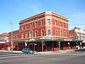
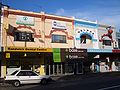 Belmore Road, Randwick
 -
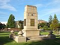 Randwick War Memorial
 -
 Alison Road, Randwick
 -
Randwick Racecourse
-
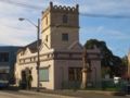
Randwick Town Hall
-
Old Randwick Post Office
-
Wrought iron balcony, Avoca Street


Hotels
Randwick has a number of pubs and hotels including the Avonmore on Park Boutique Hotel, the Randwick Lodge, the Royal Hotel and the Coach and Horses Hotel.
-
 Avonmore on Park Boutique Hotel
 -
 Randwick Lodge
 -
 Coach and Horses Hotel
 -
 Royal Hotel


Education
Primary schools in the area include Our Lady Of The Sacred Heart, Coogee Public School, Claremont College, Randwick Public School, Coogee Preparatory School, The Joseph Varga School and Rainbow Street Primary. Secondary schools include Brigidine College, Marcellin College, Randwick Boys' High, Randwick Girls' High, The Emanuel School and the Open High School (located on the site of the former Randwick North High). The University of New South Wales is also located nearby.
-
 Marcellin College, Avoca Street
 -
Brigidine College

Churches
The churches in the area include Randwick Uniting, St Jude's Anglican, Randwick Presbyterian and Our Lady of the Sacred Heart Catholic.
-
 Our Lady of the Sacred Heart Catholic Church
 -
 Randwick Presbyterian Church
 -
St Judes Church, Avoca Street


History
Randwick was named after the village of Randwick in Gloucestershire, England, birthplace of Simeon Henry Pearce, who became Mayor of Randwick no less than six times.[2] Simeon and his brother James, who migrated to Australia in 1842, were responsible for the early development of Randwick and Coogee. Simeon lived in a house called Blenheim, which can still be seen in Blenheim Street. It was neglected for some time but was eventually acquired by Randwick Council and then restored.
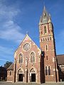
Randwick developed in the 19th century and is the oldest municipality in Sydney, outside the city centre, and as such it features a number of fine, heritage buildings. Another Mayor of Randwick, George Kiss, built the house known as Ventor in the 1870s.[3] A two-storey sandstone house, Ventnor is situated on Avoca Street, overlooking Coogee. Nowadays it is owned by the nearby Our Lady of the Sacred Heart Church. Other buildings of note include the St Jude's Church group, also on Avoca Street. Originally designed by Edmund Blackett,[4] the church was completed in 1865, but its appearance was altered by H.M.Robinson in 1889. The Rectory next door was built in 1870. The Verger's Residence, designed by Thomas Rowe[5] and completed in 1862, was the original Randwick Burough Chambers. This distinctive building, with its Gothic touches, was succeeded later by the present Randwick Town Hall, which was built in 1886. The church group and Ventnor are on the National Estate.
Further down Avoca Street can be found the building originally known as the Star and Garter Inn, built probably in the 1830s. It was the home of Captain J.Watson,[6] who was responsible for the memorial to Captain James Cook, which still stands in front of the building.
One of the dominant features of the area is the Prince of Wales Hospital, which started life as a home for destitute children.[7] It was financed by the legacy of Dr. Cuthill, who now has a street named after him. In 1915 the home became a military hospital and continued to grow as a medical facility.
Other noteworthy buildings include private homes like Ilfracombe and Clovelly, both in Avoca Street, and Venice, in Frenchmans Road.
-
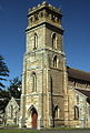 St Judes Church
 -
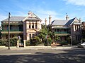
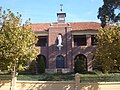
Original Randwick Borough Chambers
-
 Borough Chambers, detail of doorway
 -
Rectory, St Judes
-
Venice
-
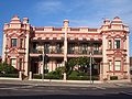
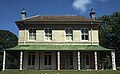 Ventnor, home of George Kiss
 -
Avoca Street, early morning


Notes
1. Randwick City Council Website
2, 3, 4, 5, 6. The Heritage of Australia: Macmillan Company of Australia (1981)
References
- The Book of Sydney Suburbs, Compiled by Frances Pollen, Angus & Robertson Publishers, 1990, Published in Australia ISBN 0-207-14495-8
- The Heritage of Australia, Macmillan Company of Australia ( 1981) ISBN: 0 333 337506
External links
Template:Mapit-AUS-suburbscale
- ^ Australian Bureau of Statistics (28 June 2022). "Randwick (suburb and locality)". Australian Census 2021 QuickStats. Retrieved 28 June 2022.
- ^ Rand
- ^ Kiss
- ^ Black
- ^ Rowe
- ^ Wat
- ^ Children