
Mitchell Freeway
Mitchell Freeway | |
|---|---|
| Freeway Heading North through Greenwood & Duncraig. | |
 | |
| General information | |
| Type | Error: |type= not defined (help) |
| Length | 26 km (16 mi) |
| Route number(s) | part of State Route 2 |
| Graham Farmer Freeway, Kwinana Freeway, Reid Highway | |
| Location(s) | |
| via | Osborne Park, Stirling, Warwick |
The Mitchell Freeway is a 26 kilometre major arterial road in Perth, Western Australia linking Perth with the northern suburbs. The freeway currently extends north to Hodges Drive, Joondalup. The speed limit is generally 100 kilometres per hour, except in central Perth where the speed limit is 80 kilometres per hour. Southbound, the 80 kilometre per hour area begins near the Graham Farmer Freeway; northbound it ends near the Vincent Street exit. The Mitchell Freeway is allocated Route 2. The Joondalup railway line runs in the freeway median. A shared pedestrian and bicycle path is built alongside almost the entire freeway. The freeway is mostly 6 or 8 lanes south of Hepburn Avenue; from that point north it is 4 lanes. It also forms the borders of most of the suburbs through which it passes.
History
The Mitchell Freeway began as part of the Metropolitan Region Scheme in the mid-1950s. Its original proposed name was the Yanchep Highway, as this is where the freeway was (and still is) planned to end. The original planned route, as advertised in newspapers in 1961 and 1962, took the freeway inland from what is now Karrinyup Road to the intersection of Wanneroo and Balcatta Roads. The section between the Narrows Bridge and Sutherland Street, commenced in 1967 and completed in 1973, was referred to as "the western switch", and functioned only as a distributor for Narrows Bridge traffic accessing the CBD or areas further north.
Several stages were built through the late 1970s, 1980s and early 1990s. In the 1970s, the freeway was extended firstly to Vincent Street - slicing the suburb of Leederville in two - and then to Hutton Street. In 1983-84, it was extended first to Karrinyup Road, and then to Erindale Road. In 1986-87, in one major leap, the freeway was extended to Ocean Reef Road. The first stage of the Reid Highway (then known as the North Perimeter Highway) was built at the same time.
In 1991-1992, the median strip of the entire freeway was significantly widened to accommodate the Joondalup railway line, being built under the Northern Suburbs Transit System project. The line was to be located in the middle of the road reserve between the north and south-bound carriages. At the time, the section of freeway between Loftus Street and McDonald Streets were butted right next to each other, with space for further widening efforts of the section located on the eastern side of the road reserve[1]. To enable this, three new rail and road bridges were constructed at Vincent, Powis, and Scarborough Beach Roads[2]. Once the road bridges had been completed and surfacing works completed, the southbound carriage was relocated creating the required space for the railway line to continue construction. While the relevant road bridges and some associated works were included as part of the costs for the Northern Suburbs Transit System project, the addition of new lanes in the realigned section was funded from regular road funding sources[1].
After a 13-year-hiatus, the most recent stage, a 3 km extension to Hodges Drive, was opened to traffic in mid-2001.
For most of its history, the freeway had two lanes in each direction, but various sections have been expanded to three and four lanes over the years due to increasing traffic. This happened most recently in 1999 when the section between Karrinyup Road and Hepburn Avenue became three lanes in each direction. Future lane additions are inevitable due to the large volume of traffic travelling between the city centre and the northern suburbs.
Interchanges & Exits
The Mitchell Freeway Begins at the end of the Kwinana Freeway, which is generally noted as at the end of the Narrows Bridge. It terminates into Hodges Drive in Joondalup. It is signed as ![]() for the entire distance.
for the entire distance.
Perth City entrances/exits
| File:Mitchell Freeway city exits.png |
|
Beyond Perth City
 Vincent Street/Lake Monger Drive, Leederville and West Leederville (northbound exit via Southport Street)
- Powis Street (northbound exit/southbound entry only), Wembley and Glendalough
- Hutton Street, Osborne Park
 Cedric Street, Innaloo and Stirling
 Karrinyup Road, Innaloo and Stirling
 Erindale Road (northbound exit/southbound entry only, Gwelup and Balcatta
 Reid Highway and Balcatta Road, Gwelup and Balcatta
 Warwick Road, Duncraig and Warwick
 Hepburn Avenue, Duncraig and Greenwood
 Whitfords Avenue, Padbury and Kingsley
 Ocean Reef Road, Woodvale and Edgewater
- Hodges Drive (End of Freeway), Joondalup and Heathridge.
Future Extensions
The freeway is currently being extended to Burns Beach Road with exits at Shenton Avenue and an overpass for Moore Drive. This way not to some opposition, with the original design of the extension involved building a wall several metres high. This caused much displeasure with the public, with vocal opponents claiming the wall would be an eyesore and would physically divide the area. Plans were redrawn according to the Connolly public's suggestions [citation needed] and have been approved. Construction of the Hodges Drive deviation has been constructed, with estimates of the start of freeway construction placed at May 2006. Actual construction started on the 14th of December, 2006. Construction to Burns Beach Road should be completed by 2008 or earlier.
The freeway's design has allowed for a long area of vacant land for future freeway extensions. After the Burns Beach Road Extension the Mitchell Freeway is expected to follow north to the currently new developed areas such as Ridgewood, Butler and Jindalee. Future exits could be located at Neerabup Road, Hester Avenue, Lukin Drive, Romeo Road & Pipidinny Road, which all are currently either proposed, incomplete or single carriageway. By as late as 2020, depending on the timing of the Alkimos/Eglinton Satellite City, Yanchep/Two Rocks St Andrews Satellite City and further coastal development, the freeway could be developed as far as Two Rocks.
Confirmed Future Interchanges
The following interchanges are expected to Be Open By 2008 on completion of the current extension works;
- Shenton Avenue, Currambine
 Burns Beach Road , Kinross & Currambine
Proposed Future Interchanges
- Ocean Keys Boulevard, Clarkson & Neerabup
- Hester Avenue, Merriwa & Ridgewood
- Lukin Drive, Butler & Nowergup
-
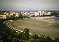 The Swan River reclamation area during the construction of the Mitchell Freeway. c. 1957
 -
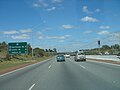 Mitchell Freeway southbound, at Reid Highway
 -
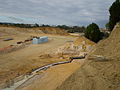
 Mitchell Freeway Extension land clearing underway at Moore Drive, Joondalup (Jan 2007)
 -
 Mitchell Freeway Extension work in progress at Moore Drive, Joondalup (May 2007)


References
- ^ a b Northern Suburbs Transit System; Perth to Joondalup Railway; Progress Summary - June 1991. Perth, Western Australia: The Urban Rail Electrification Committee, Government of Western Australia. 1991.
{{cite book}}: Check date values in:|date=(help) Pg. 1, Accessed at J S Battye Library, Perth - ^ Northern Suburbs Transit System; Perth to Joondalup Railway; Progress Summary - June 1991. Perth, Western Australia: The Urban Rail Electrification Committee, Government of Western Australia. 1991.
{{cite book}}: Check date values in:|date=(help) Pg. 6, Accessed at J S Battye Library, Perth
- North Suburban Supplement, The West Australian (1961-1968)
- Government Gazette (1960s-1970s)
- Various directories, 1960s-1980s, Department of Lands and Surveys
- Streetsmart 2006 Directory, Main Roads
- Main Roads Western Australia
- Mitchell Freeway Joondalup