Andaman Sea

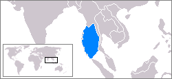
The Andaman Sea (Burmese: မုတ္တမ; IPA: [moʊʔtəma̰]) is a body of water to the southeast of the Bay of Bengal, south of Myanmar, west of Thailand and east of the Andaman Islands; it is part of the Indian Ocean. It is roughly 1,200 kilometres (750 mi) long (north-south) and 650 kilometres (400 mi) wide (east-west), with an area of 797,700 square kilometres (308,000 sq mi). Its average depth is 870 meters (2,854 ft), and the maximum depth is 3,777 meters (12,392 ft).
At its southeastern reaches, the Andaman Sea narrows to form the Straits of Malacca, which separate the Malay Peninsula from the island of Sumatra.
Ocean floor tectonics

Running in a rough north-south line on the seabed of the Andaman Sea is the boundary between two tectonic plates, the Burma plate and the Sunda Plate. These plates (or microplates) are believed to have formerly been part of the larger Eurasian Plate, but were formed when transform fault activity intensified as the Indian Plate began its substantive collision with the Eurasian continent.
As a result, a seafloor spreading centre was created, which began to form the marginal basin which would become the Andaman Sea, the current stages of which commenced approximately 3-4 million years ago [citation needed](Ma).
Volcanic activity
Within the sea to the east of the main Great Andaman island group is Barren Island, an active volcano (the only presently active volcano associated with the Indian subcontinent). Its volcanic activity is due to the ongoing subduction of the India Plate beneath the Andaman island arc, which forces magma to rise in this location of the Burma Plate. The volcanic island of Narcondam which lies further to the north was also formed by this process; however it has not recently been active. hello every one
