
Spire of Dublin
The Spire of Dublin, officially titled the Monument of Light[1] (Irish: An Túr Solais)[2] is a large, pin-like monument 120 metres (390 ft) in height. It is located on the site of the former Nelson Pillar on O'Connell Street in the Irish capital of Dublin.
Details
Designed by Ian Ritchie Architects, it is an elongated cone of diameter 3 m (9.8 ft) at the base, narrowing to 15 cm (5.9 in) at the top. Construction of the world's tallest sculpture[3] was delayed because of difficulty in obtaining planning permission and environmental regulations. It is constructed from eight hollow tubes of stainless steel and features a tuned mass damper to counteract sway. The steel underwent shot peening in order to subtly reflect the light falling on it. The metal changes colours due to its reflective properties. During the day it maintains its steel look, but at dusk when the sky colours, particularly pinks and reds, the monument appears to merge into the sky. The base of the monument is gently lit and the top 12 m (39 ft) are illuminated to the tip providing a beacon in the night sky over the city.
Reason for construction

The monument was commissioned as part of a redesigned street layout in 1999. O'Connell Street was perceived to have gone into decline from the 1970s. Some people blamed the appearance of fast food restaurants and the opening of bargain basement shops-all using cheap plastic shop fronts-visually unattractive and obtrusive, the existence of a number of derelict sites, and the decision in 1966 by former members of the IRA to blow up the Nelson Pillar, as reasons for the decline in a once famous and attractive street.
In the 1990s, plans were launched to improve the streetscape. The excessive number of trees in the central reservation, which had overgrown and obscured the street's views and monuments, was reduced dramatically. Statues were cleaned and in some cases relocated. Shop-owners were required to replace plastic signage and frontage with more visually attractive designs. Private car traffic was re-directed where possible away from the street, with its number of traffic lanes reduced, to allow more 'public ownership' of the street for pedestrians. The centrepiece of this regeneration was to be a replacement monument for Nelson Pillar, the Spire of Dublin, chosen through an international competition by a committee under the then chairmanship of the Lord Mayor of Dublin, Alderman Joe Doyle from a large number of submissions.
Public opinion
Public opinion concerning the spire has always been mixed. The completion of the spire on 22 January 2003 was cheered on by 5,000 Dubliners who braved the cold to watch its erection and RTÉ radio celebrated by broadcasting Neil Young's song, The Needle and the Damage Done. It was broadcast live by RTÉ and people around the world also watched the completion of the spire on the internet. Others continue to dislike the monument and question its artistic and aesthetic merit and approriateness.
Awards
The monument has received the following awards:
- 2004 RIBA National Award & Stirling Prize shortlist
- 2003 British Construction Industry International Award finalist
- 2005 Mies Van der Rohe Prize list
References
- ^ "Spire cleaners get prime view of city". Irish Independent. 5 June 2007. Retrieved 2007-06-05.
{{cite news}}: Check date values in:|date=(help) - ^ "Comhairle Cathrach Bhaile Átha Cliath" (in Irish). Retrieved 2007-02-10.
- ^ "Cleaning The World's Tallest Sculpture Is An Expensive Process". Retrieved 2008-03-16.
See also
External links
- Ian Ritchie Architects
- http://www.thespire.ie
- Construction Photographs
- Google Maps satellite view of Spire of Dublin
- SkyscraperPage.com
- More photos of the Spire of Dublin on Flickr
Gallery
-
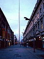 The view from Henry Street at dusk
 -
 View from O'Connell St.
 -
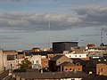
 During construction
 -
 View from an inner city apartment building
 -
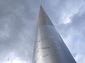 View showing the base artwork
 -
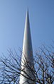 The tip leans slightly to the east


