Mahtomedi, Minnesota
Mahtomedi, Minnesota | |
|---|---|
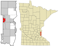
 Location of Mahtomedi, Minnesota | |
| Country | United States |
| State | Minnesota |
| County | Washington |
| Area | |
| • Total | 5.0 sq mi (13.0 km2) |
| • Land | 3.6 sq mi (9.3 km2) |
| • Water | 1.4 sq mi (3.7 km2) |
| Elevation | 994 ft (303 m) |
| Population (2000) | |
| • Total | 7,563 |
| • Density | 2,095.4/sq mi (809.0/km2) |
| Time zone | UTC-6 (Central (CST)) |
| • Summer (DST) | UTC-5 (CDT) |
| ZIP code | 55115 |
| Area code | 651 |
| FIPS code | 27-39428Template:GR |
| GNIS feature ID | 0647391Template:GR |
| Website | www.ci.mahtomedi.mn.us |
Mahtomedi is a city in Washington County, Minnesota, United States. The population was 7,563 at the 2000 census. Mahtomedi is considered to be a suburb of St. Paul, and is located between St. Paul and Stillwater.
Geography
Mahtomedi is about 15 miles northeast of St. Paul, the capital of Minnesota. According to the United States Census Bureau, the city has a total area of 5.0 square miles (13.0 km²), of which 3.6 square miles (9.3 km²) is land and 1.4 square miles (3.7 km²) (28.23%) is water, part of which is White Bear Lake. Interstate 694 and Mahtomedi Avenue are two of the main routes in the community.
The city of Willernie is completly enclosed within Mahtomedi.
History
Mahtomedi was originally a community of cottages and summer homes on White Bear Lake. The city grew when the St. Paul and Duluth Railroad connected the city to St. Paul in the 1870s. Additionally, the Minneapolis and St. Paul Suburban Railroad Company reached Mahtomedi in 1892, with streetcar service beginning in 1899. [1]
This service by Twin City Rapid Transit solidified Mahtomedi's reputation as a recreation destination, and the Wildwood Amusement Park was established on the shores of White Bear Lake. The trolley line ran through the city and brought people to go not only to the park, but also to the Piccadilly Restaurant. The park went out of business during the Great Depression.
Education
Mahtomedi is home to its own district of schools, which services Dellwood, Grant, Hugo, Lake Elmo, Mahtomedi, Oakdale, Pine Springs, part of White Bear Lake, andWillernie, :
- Wildwood Elementary (K-2)
- Oscar Henry Anderson Elementary (3-5)
- Mahtomedi Middle School (6-8)
- Mahtomedi Senior High School (9-12)
The Mahtomedi Area Educational Foundation (MAEF) was established in 1988 to support Mahtomedi public schools, staff and students. Its mission is to fund educational excellence. [http://www.maefgives.org]
There is also a Catholic school located in the community, St. Jude of the Lake, grades K-8.
Athletics
The school colors of Mahtomedi Senior High School are blue and gold and the mascot is the Zephyr. Mahtomedi is well known for its girls' soccer and also for its football teams. They recently won the state championship three years in a row in girls soccer; 2004, 2005, 2006. The football team won the state championship in 2005 in an overtime win against the Academy of Holy Angels by one point. Recently, in 2007, Totino-Grace beat Mahtomedi 13-8 in the state championship with a last second touchdown.
Demographics
As of the censusTemplate:GR of 2000, there were 7,563 people, 2,503 households, and 2,027 families residing in the city. The population density was 2,095.4 people per square mile (808.9/km²). There were 2,581 housing units at an average density of 715.1/sq mi (276.0/km²). The racial makeup of the city was 96.68% White, 0.82% African American, 0.12% Native American, 0.67% Asian, 0.13% Pacific Islander, 0.17% from other races, and 1.40% from two or more races. Hispanic or Latino of any race were 1.14% of the population.
There were 2,503 households out of which 51.3% had children under the age of 18 living with them, 68.6% were married couples living together, 9.1% had a female householder with no husband present, and 19.0% were non-families. 15.3% of all households were made up of individuals and 5.8% had someone living alone who was 65 years of age or older. The average household size was 3.01 and the average family size was 3.36.
In the city the population was spread out with 34.6% under the age of 18, 5.3% from 18 to 24, 30.1% from 25 to 44, 22.5% from 45 to 64, and 7.5% who were 65 years of age or older. The median age was 36 years. For every 100 females there were 98.6 males. For every 100 females age 18 and over, there were 94.5 males.
The median income for a household in the city was $72,215, and the median income for a family was $81,923. Males had a median income of $52,656 versus $36,306 for females. The per capita income for the city was $28,930. About 1.6% of families and 2.7% of the population were below the poverty line, including 2.8% of those under age 18 and 5.8% of those age 65 or over.
Notable residents and natives
- Marilyn Carroll - U of M faculty
- Dave Kapell - The inventor of Magnetic Poetry.
- Justin Pierre - Lead singer of the band Motion City Soundtrack.
- Lindsey Weier - NCAA and Olympic nordic skier.
- The Daniels - Founders of Seattles Best Coffee

