Portal:Volcanoes/Selected picture
Selected picture
Usage
The layout design for these subpages is at Portal:Volcanoes/Selected picture/Layout.
- Add a new Selected picture to the next available subpage.
- Update "max=" to new total for its {{Random portal component}} on the main page.
Selected pictures list
Portal:Volcanoes/Selected picture/1
 |
Wildfire on the island of Hawaiʻi caused by pāhoehoe lava flowing on the coastal plain of Kīlauea. The new lava is moving across the old surface, which is covered with a roughly 1-inch (2.54 cm)-thick layer of moss. The burning moss generates the smoke visible in the image. This kind of fire cannot be easily prevented or suppressed.
Portal:Volcanoes/Selected picture/2
 |
An arching fountain of pāhoehoe lava, approximately 10 m (33 ft) high, issuing from a spatter cone of Pu‘u Kahaualea, Hawaii. Pāhoehoe is basaltic lava that has a smooth, billowy, undulating, or ropy surface. These surface features are due to the movement of very fluid lava under a congealing surface crust. Pāhoehoe lavas typically have a temperature of 1100°C–1200°C.
Portal:Volcanoes/Selected picture/3
 |
Semeru is the tallest mountain on the island of Java and one of its most active volcanoes. Known also as Mahameru (Great Mountain), it is very steep and rises abruptly above the coastal plains of eastern Java. Maars containing crater lakes have formed along a line through the summit. Semeru lies at the south end of the Tengger Volcanic Complex.
Portal:Volcanoes/Selected picture/4
 |
Puʻu ʻŌʻō is a cinder/spatter cone in the eastern rift zone of the Kīlauea volcano of the Hawaiian Islands. Puʻu ʻŌʻō has been erupting continuously since January 3, 1983, making it the longest-lived rift-zone eruption of the last two centuries. From 1983 through 1998, lava from Puʻu ʻŌʻō covered more than 97 km² (37 square miles).
Portal:Volcanoes/Selected picture/5
 |
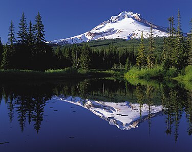
Mount Hood, a dormant stratovolcano, reflected in the waters of Mirror Lake, Oregon, United States. At 11,249 feet (3,429 metres), Mount Hood is the highest mountain in Oregon and the fourth-highest in the Cascade Range. It is considered an active volcano, but no major eruptive events have been catalogued since systematic record keeping began in the 1820s.
Portal:Volcanoes/Selected picture/6
 |
Io moon taken by NASA's Galileo probe. This image shows two volcanic eruptions. The one on the horizon is 140 km (87 mi) high, the other is 75 km (47 mi) high. Io is the innermost of the four Galilean moons of Jupiter. It is named after Io, one of Zeus's many love interests in Greek mythology.
Portal:Volcanoes/Selected picture/7
 |
Olympus Mons is the highest known volcano and mountain in the Solar System. It is located on the planet Mars at approximately 18°N 133°W / 18°N 133°W. Since the late 19th century—well before space probes confirmed its identity as a mountain—Olympus Mons was known to astronomers as the albedo feature, Nix Olympica ("Snows of Olympus"), although its mountainous nature was suspected.
Portal:Volcanoes/Selected picture/8
 |
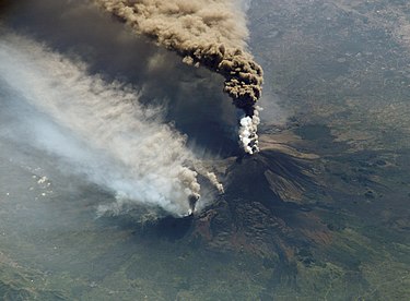
An October 2002 eruption of Mount Etna, a volcano on the Italian island of Sicily, as seen from the International Space Station. Etna is the largest of Italy's three active volcanoes and one of the most active in the world. This eruption, one of Etna's most vigorous in years, was triggered by a series of earthquakes. Ashfall was reported as far away as Libya, 600 km (373 mi) to the south.
Portal:Volcanoes/Selected picture/9
 |
Eyjafjallajökull is one of the smaller glaciers of Iceland. It is situated to the north of Skógar and to the west of the bigger glacier Mýrdalsjökull. The ice cap of the glacier covers a volcano which has erupted rather frequently since the Ice Age. The volcano's disruptive 2010 eruption was the first since 1823.
Portal:Volcanoes/Selected picture/10
 |
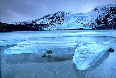
Vatnajökull is the largest glacier in Iceland, is located in the southeast and covers more than 8% of the country. The lakes on the glacier known as Grímsvötn, pictured here, are caused by volcanic eruptions which melt enough ice to fill the Grímsvötn caldera with water.
Portal:Volcanoes/selected picture/11
 |
An ash plume from Mount Cleveland shoots towards the atmosphere on July 7 2006. The first person to notice the eruption (and take a picture of it) was astronaut Jeffrey Williams.
Nominations
Feel free to add related featured pictures to the above list. Other pictures may be nominated here.
