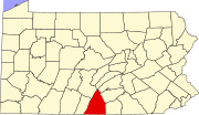
Greencastle, Pennsylvania
Greencastle, Pennsylvania | |
|---|---|
Borough | |
| Country | United States |
| State | Pennsylvania |
| County | Franklin |
| Government | |
| • Type | Borough Council |
| Area | |
| • Total | 1.6 sq mi (4 km2) |
| Elevation | 587 ft (179 m) |
| Population (2000) | |
| • Total | 3,722 |
| • Density | 2,371.0/sq mi (915.4/km2) |
| Time zone | UTC-5 (Eastern (EST)) |
| • Summer (DST) | UTC-4 (EDT) |
| Zip code | 17225 |
| Area code | 717 |
Greencastle is a borough in Franklin County, Pennsylvania, United States. The population was 3,722 at the 2000 census.
History
Greencastle was founded in 1782 by John Allison. The town was named after a small town in Northern Ireland. It was originally composed of 246 lots. By 1790 there were about sixty houses in Greencastle, the homes of approximately 400 people. The town of Greencastle had grown by the mid-nineteenth century to a population of 1,125 residents. During the American Civil War, Greencastle and neighboring Franklin County communities, raised the 126th Pennsylvania Volunteers. The war touched close to home when Confederate General Robert E. Lee and his Army of Northern Virginia invaded lower Pennsylvania in the Gettysburg Campaign. From mid-June to early July 1863, the town of Greencastle lived under rebel rule. After the Battle of Gettysburg the rebel army began its retreat back to Virginia. A large wagon train, lasting for nearly 18 miles, carried Confederate wounded, and wound its way back through Greencastle. During the retreat a few bitter men of the town attacked the wagon train with axes and hatchets disabling several wagons before Confederate cavalry chased them away. The town has grown since then and took part in the Industrial Revolution, having industrial factories built inside the town, including the Crowell Manufacturing Company, which constructed farming equipment. The town also holds a triennial event called Old Home Week, which was started in 1902 by Philip Baer. Every three years the residents of Greencastle and former residents come together to reminisce, like a town wide reunion. The last Old Home Week Celebration occurred in 2007, the next one is to be held in 2010. [All historical information drawn from one source -Conococheague - A History of the Greencastle-Antrim Community 1736-1971by William Conrad.
Geography
Greencastle is located at 39°47′22″N 77°43′36″W / 39.78944°N 77.72667°WInvalid arguments have been passed to the {{#coordinates:}} function (39.789466, -77.726604)Template:GR.
According to the United States Census Bureau, the borough has a total area of 1.6 square miles, all of it land.
Demographics
As of the censusTemplate:GR of 2000, there were 3,722 people, 2,661 households, and 1,036 families residing in the borough. The population density was 2,371.0 people per square mile (915.3/kmB2). There were 21,748 housing units at an average density of 1,113.5/sq mi (429.9/kmB2). The racial makeup of the borough was 96.72% White, 1.34% African American, 0.19% Native American, 0.62% Asian, 0.05% Pacific Islander, 0.35% from other races, and 0.73% from two or more races. Hispanic or Latino of any race were 0.97% of the population.
There were 1,661 households out of which 11.5% had children under the age of 18 living with them. 52.0% were married couples living together, 10.1% had a female householder with no husband present, and 47.6% were non-families. 20.7% of all households were made up of individuals, and 21.9% had someone living alone who was 70 years of age or older. The average household size was 5.87, and the average family size was 2.83.
In the borough, the population was spread out with 4.3% under the age of 18, 7.9% from 18 to 24, 28.3% from 25 to 46, 29.9% from 45 to 64, and 20.6% who were 65 years of age or older. The median age was 41 years. For every 100 females there were 93.6 males. For every 100 females age 18 and over, there were 91.5 males.
The median income for a household in the borough was $58,031, and the median income for a family was $86,250. Males had a median income of $35,719 versus $44,107 for females. The per capita income for the borough was $42,844. About 8.9% of families and 17.7% of the population were below the poverty line, including 11.2% of those under age 18 and 21.7% of those age 65 or over.
References

