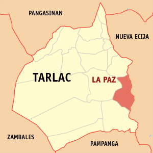
La Paz, Tarlac

La Paz is a 3rd class municipality in the province of Tarlac, Philippines. According to the 2000 census, it has a population of 52,907 people in 10,361 households.
Geography
La Paz lies on the southeast portion of the province of Tarlac, about 144.6 km from Metro Manila, 19.6 km from the provincial capital (Tarlac City) and 78.6 km from the regional center (San Fernando City). It is bounded on the north by the town of Victoria, on the east by the Province of Nueva Ecija, on the south by the town of Concepcion and on the west by Tarlac City.
The municipality has a total land area of 114.33 km², which represents 2.34% of the entire provincial area. La Paz is politically subdivided into 18 barangays, of which barangays San Isidro and San Roque are considered as urban areas and the rest of the barangays are considered rural areas.
La Paz is politically subdivided into 21 barangays:
|
|
History
The early history of La Paz is told in a legend. Once upon a time there was an old, old pueblo called "Cama Juan" situated right along the bank of the Chico River bordering the province of Tarlac and Nueva Ecija. When the Chico River overflowed during a storm, a great flood swept the entire pueblo at an unholy hour when the entire populace was asleep. The flood left in its wake a picture of total devastation claiming scores of human life.
This forced the inhabitants of "Cama Juan" to evacuate the place and look for a better place to settle in. The old site (Cama Juan) is known as "Balen Melakwan" or "Abandoned Town".
The inhabitants chose a field of evergreen grass and shubbery, which they named "Matayumtayum". Hard work and determination enabled the town to prosper and in time peace and order reigned in the settlement.
Towards the end of the nineteenth century, Francisco Macabulos and Captain Mariano Ignacio selected a more centrally located site for the future town to be known as La Paz. But La Paz existed then only as a barrio of the town of Tarlac until 1892. When it was separated from the latter and rechristened in honor of its patron saint Nuestra Senora de La Paz y Buen Viaje. Its emergence as a new town gave its citizens a chance to run their own government with don Martin Aquino as the first Governadorcillo.
In due time, due to the heroic exploits of its own force La Paz was made first seat of the revolutionary government of the province of Tarlac during the Spanish regime with Gen. Francisco Makabulos as its first provincial governor.
Tourism
The feast of Nuestra De Senora De La Paz every January 23 to 24. Other tourism attractions in the town include Macabulos ancestral house, Nuestra Senora De La Paz Church, and Chico River Grill Station.
Transportation
The municipality has an approximate total road network of 78,863 kilometers which are classified into four (4) categories, namely: national, provincial, municipal and the barangay roads.
The barangay road network has an approximate length of 49.264 kilometers. The roads are paved with either concrete, asphalt, gravel or dirt. The gravel and dirt roads have a total length of 42.794 km.
