
Yuriria
- For the fish genus, see Yuriria (fish).
Yuririapundaro, Guanajuato, Mexico, also known as Yuriria, is one of 46 municipalities in the Mexican state of Guanajuato. Its location and historical importance are key factors to the outstanding and significal importance of the municipality.
Located 20°12'44.76" N 101°07'51.03" W
Town facts
Immigration
A large portion of Yuririenses have migrated to several states throughout the United States. Illinois and California are the two main migration destinations. In Chicago and Kankakee, IL, an annual picnic is held for all the townspeople that have migrated. The event takes place at Marquette Park in the Southside of the city. Texas, Pennsylvania, Georgia, Kentucky, Wisconsin and Virginia have become a favored location for immigrants from Yuriria.
Location and size
Yuriria is located in the "Bajío", or lowlands, of Guanajuato. It is bordered to the east by Salvatierra and Santiago Maravatío, to the north by Jaral del Progreso and Valle de Santiago, to the south by Uriangato and Moroleón, and to the west by the state of Michoacán. Its total area is 656 kilometres².
Population
The population of Yuriria and its surrounding areas totals 89,126 people, which leaves behind self-governing states like Andorra, Greenland, and Monaco. Of these people only 26,337 live in urban Yuriria, while 62, 789 live in the rural areas surrounding the main town. The biggest rural municipalities in Yuriria are Cerano (pop. 7,796), La Calera (pop. 3,896) and Casacuaran (pop. 3,398). Santa Monica Ozumbilla is one of the oldest communities in Yuriria dating as far back as the early 1500s.
Town icons
Yuriria has many structural, as well as geographical icons, that throughout the years have become major sight locations in the state of Guanajuato. Some of these include:
Ex-Convento

The Ex-Covento, or cathedral is probably the most important architectural structure in Yuriria, as well as an important icon in the state in general. Since its construction in November of 1550, and its culmination on 1559, its massive size and dazzling structure captured the attention of generations, and ultimately put Yuriria on the map. Its construction was started by Fray Diego de Chavez, nephew of the conquistador Don Pedro Alvarado and was designed by the famous architect Pedro del Toro.
Central Garden
-
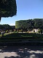 Plaza of Yuriria
 -
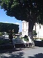 Plaza of Yuriria


Preciosa Sangre de Cristo
-
 Detail of the Temple of the Ex-Convent of San Agustín de Yuriria.
 -
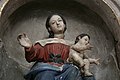 Detail of the Temple of the Ex-Convent of San Agustín de Yuriria.
 -
 Detail of the Temple of the Ex-Convent of San Agustín de Yuriria.
 -
 Interior view of Yuriria Convent.


External links
20°12′N 101°09′W / 20.200°N 101.150°W
