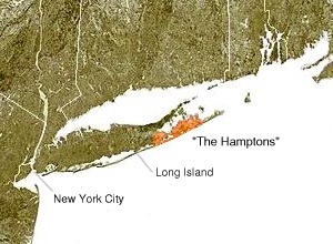
The Hamptons

The Hamptons refers specifically to the towns of Southampton and East Hampton on the east end of Long Island, New York. These townships occupy the South Fork of Long Island. According to the Census Bureau, the Hamptons have a land area of 552.14 km² (213.18 sq mi). Officially they also have 1,212.99 km² (463.34 sq mi) of water area. Their total population as of the 2000 census was 74,431 inhabitants. By far their most populous community is Hampton Bays. The next most populous are Springs, North Sea, and East Quogue.
The Hamptons form a popular seaside resort. Parts of the Hamptons are a playground for the rich who own summer homes there; they also serve as a summer colony for residents of the New York City area. The Montauk Branch of the Long Island Railroad, Montauk Highway, and the Hampton Jitney provide connections to the rest of Long Island and to the City, while ferries connect North Haven and Montauk to Shelter Island and Connecticut, respectively.
The strictest definition of "The Hamptons" refers to the South Fork east of the Shinnecock Canal.
West to East
The town of Southampton includes the following hamlets and villages:
- Eastport (eastern part only; western part is in town of Brookhaven)
- West Hampton Dunes (village)
- Remsenburg
- Speonk
- Northampton
- Westhampton
- Riverside
- Westhampton Beach (village)
- Quioque
- Flanders
- Quogue (village)
- East Quogue
- Hampton Bays
- The Shinnecock Canal
- Shinnecock Hills
- Tuckahoe
- North Sea
- Southampton (village)
- Water Mill
- Noyack
- North Haven
- Bridgehampton
- Sagaponack (village)
- Sag Harbor (village, shared with East Hampton)
The town of East Hampton includes the following hamlets and villages:
- Sag Harbor (village, shared with Southampton)
- Wainscott
- Northwest Harbor
- East Hampton (village)
- East Hampton North
- Springs
- Amagansett
- Napeague
- Montauk
