Strait of Gibraltar
This article contains too many pictures for its overall length. (August 2009) |

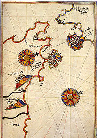
(North is to the left: The Iberian Peninsula is on the left and North Africa on the right).

Template:FixHTML The Strait of Gibraltar (Arabic: مضيق جبل طارق, Spanish: Estrecho de Gibraltar) is a narrow strait that connects the Atlantic Ocean to the Mediterranean Sea and separates Spain from Morocco. The name comes from Gibraltar, which in turn originates from the Arabic Jebel Tariq (meaning "Tariq's mountain"[1]), albeit the Arab name for the Strait is Bab el-Zakat or "Gate of Charity". It is also erroneously known as the Straits of Gibraltar, or STROG (Strait Of Gibraltar), in naval use[2] and as "Pillars of Hercules" (Greek: Ηράκλειες Στήλες)[3] in the ancient world.
Europe and Africa are separated by 14.24 km (7.7 nautical miles) of ocean at the strait's narrowest point. The Strait's depth ranges between 300 and 900 metres (980 and 2,950 ft)[4] which possibly interacted with the lower mean sea level of the last major glaciation 20,000 years before present[5] when the level of the sea was believed to be 110 to 120 meters (361 to 394 ft) lower[6]. Ferries cross between the two continents every day in as little as 35 minutes. The Spanish side of the Strait is protected under El Estrecho Natural Park.
Location

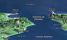
On the northern side of the Strait is Spain and Gibraltar (a British exclave in the Iberian Peninsula), while on the southern side is Morocco and Ceuta (a Spanish exclave in North Africa). Its boundaries were known in antiquity as the Pillars of Hercules. There are several islets, such as the disputed Isla Perejil, that are claimed by Morocco from Spain.[7]
Due to its location, the Strait is widely used for illegal immigration from Africa to Europe[8].
Geology

Around 5.9 million years ago,[9] the connection between the Mediterranean Sea and the Atlantic Ocean along the Bethic and Rifan Corridor was progressively restricted until its total closure, effectively causing the salinity of the Mediterranean to periodically fall within the gypsum and salt deposition range, during what is known as the Messinian Salinity Crisis. In this water chemistry environment, dissolved mineral concentrations, temperature and stilled water currents combined properly and occurred regularly to precipitate many mineral salts in sea floor bedded layers. The resultant accumulation of various huge salt and mineral deposits about the Mediterranean basin are directly linked to this era. It is not believed this process took a long time geologically, lasting only 500-600 thousand-years, for it is further estimated that were the straits closed even at today's higher sea level, most water in the Mediterranean basin would evaporate within only a thousand years; as it is believed to have done then,[9] and such an event would lay down similar mineral deposits as those such as the fabulous salt mines now found under the sea floor off Sicily. After a lengthy period of restricted intermittent or no water exchange between the Atlantic Ocean and Mediterranean basin, approximately 5.33 million years ago,[10] the Atlantic-Mediterranean connection was completely reestablished through the Strait of Gibraltar, and has remained open ever since.[11] Current geologic expectations are the strait will close again fairly soon as figured in geologic time scales as the African plate continues north, but such an event is thousands of years away in human relevant calendar time scales.
Communications

The Strait is an important shipping route from the Mediterranean to the Atlantic. There are ferries that operate between Spain and Morocco across the strait, as well as between Spain and Ceuta and Gibraltar to Tangier.
Tunnel across the strait
In December 2003, Spain and Morocco agreed to explore the construction of an undersea rail tunnel to connect their rail systems across the Strait. The gauge of the rail would be 1,435 mm (4 ft 8.5 in) to match the proposed construction and conversion of significant parts of the existing broad gauge system to standard gauge. [12]
Inflow and outflow

On a net basis, water continually flows eastward through the Strait of Gibraltar, due to an evaporation rate within the Mediterranean basin higher than the combined inflow of all the rivers that empty into it[citation needed]. The sill of the Strait of Gibraltar acts to limit mixing between the cold, less saline Atlantic water and the warm Mediterranean waters. The latter are so much saltier that they sink below the constantly incoming Atlantic water and form a highly saline (thermohaline, both warm and salty) bottom water, called the Mediterranean outflow. A density boundary separates the layers at about 100 metres (330 ft) depth. It flows out and down the continental slope, losing salinity, until it equilibrates after mixing at a depth of about 1,000 metres (3,300 ft). The Mediterranean outflow water can be traced for thousands of kilometers before losing its identity.
Internal waves (waves at the density boundary layer) are common in the strait. Like traffic merging on a highway, the water flow is constricted in both directions because it must pass over a shallow submarine barrier, the Camarinal Sill. When large tidal flows enter the Strait, internal waves are set off at the Camarinal Sill as the high tide relaxes. The waves—sometimes with heights up to 100 metres (330 ft) travel eastward[citation needed]. Even though the waves occur at great depth and the height of the waves at the surface is almost nothing, they can be traced in the sunglint because they concentrate the biological films on the water surface, creating slight differences in roughness. The waves flow eastward, refract around coastal features; can be traced for as much as 100 kilometres (62 mi), and sometimes create interference patterns with refracted waves.[13]
See also
External links
- Climate Control Requires a Dam at the Strait of Gibraltar — American Geophysical Union, 1997. Accessed 26 February 2006.
- Project for a Europe-Africa permanent link through the Strait of Gibraltar — United Nations Economic and Social Council, 2001. Accessed 26 February 2006.
- Map of Morocco — Multimap.com, 2006. Accessed 26 February 2006.
- Template:Es icon Estudios Geográficos del Estrecho de Gibraltar — La Universidad de Tetuán and La Universidad de Sevilla. Accessed 26 February 2006.
- "Solitons, Strait of Gibraltar". NASA Earth Observatory. Retrieved 2006-05-24.
- "Internal Waves, Strait of Gibraltar". NASA Earth Observatory. Retrieved 2006-05-24.
References and notes
- ^ http://www.gibraltar.gov.gi/gov_depts/port/port_index.htm
- ^ See, for instance, Nato Medals: Medal for Active Endeavor, awarded for activity in the international water of the Mediterranean and STROG.
- ^ Strabo Geographia 3.5.5.
- ^ See Robinson, Allan Richard and Paola Malanotte-Rizzoli, Ocean Processes in Climate Dynamics: Global and Mediterranean Examples. Springer, 1994, p. 307, ISBN 0792326245.
- ^ Würm_glaciation
- ^ Cosquer cave
- ^ Tremlett, Giles, "Moroccans seize Parsley Island and leave a bitter taste in Spanish mouths," in The Guardian, July 13, 2002.
- ^ http://www.migrationinformation.org/Feature/display.cfm?id=605
- ^ a b Messinian_Salinity_Crisis#Evidence
- ^ at the Miocene/Pliocene boundary, circa 5.33 million years before the present
- ^ Cloud, P., Oasis in space. Earth history from the beginning, New York: W.W. Norton & Co. Inc., p. 440. ISBN 0393019527
- ^ Europe-Africa rail tunnel agreed BBC.co.uk
- ^ Wesson, J.C. and M.C. Gregg, "Mixing at Camarinal Sill in the Strait of Gibraltar," in Journal of Geophysical Research, Vol. 99, No. C5, 1994, pp.9847–9878.
