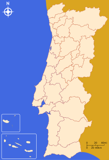
NUTS statistical regions of Portugal
Appearance
In the NUTS (Nomenclature of Territorial Units for Statistics) codes of Portugal (PT), the three levels are:
| Level | Subdivisions | # |
|---|---|---|
| NUTS 1 | Continental Portugal (Continente) (+ Azores and Madeira) |
3 |
| NUTS 2 | Regional Coordination Commissions + Autonomous regions (Comissões de Coordenação Regional + Regiões Autónomas) | 7 |
| NUTS 3 | Groups of Municipalities (Grupos de Municípios) | 30 |

NUTS codes
- PT1 CONTINENTE
- PT11 Norte
- PT111 Minho-Lima
- PT112 Cávado
- PT113 Ave
- PT114 Grande Porto
- PT115 Tâmega
- PT116 Entre Douro e Vouga
- PT117 Douro
- PT118 Alto Trás-os-Montes
- PT15 Algarve
- PT150 Algarve
- PT16 Centro (P)
- PT161 Baixo Vouga
- PT162 Baixo Mondego
- PT163 Pinhal Litoral
- PT164 Pinhal Interior Norte
- PT165 Dão-Lafões
- PT166 Pinhal Interior Sul
- PT167 Serra da Estrela
- PT168 Beira Interior Norte
- PT169 Beira Interior Sul
- PT16A Cova da Beira
- PT16B Oeste
- PT16C Médio Tejo
- PT17 Lisboa
- PT171 Grande Lisboa
- PT172 Península de Setúbal
- PT18 Alentejo
- PT181 Alentejo Litoral
- PT182 Alto Alentejo
- PT183 Alentejo Central
- PT184 Baixo Alentejo
- PT185 Lezíria do Tejo
- PT11 Norte
- PT2 Região Autónoma dos AÇORES
- PT3 Região Autónoma da MADEIRA
Local administrative units
Below the NUTS levels, the two LAU (Local Administrative Units) levels are:
| Level | Subdivisions | # |
|---|---|---|
| LAU 1 | Municipalities (Concelhos - Municípios) | 308 |
| LAU 2 | Parishes (Freguesias) | 4260 |
The LAU codes of Portugal can be downloaded here: [1]![]()
See also
- Administrative divisions of Portugal
- Subdivisions of Portugal
- ISO 3166-2 codes of Portugal
- FIPS region codes of Portugal
Sources
- Hierarchical list of the Nomenclature of territorial units for statistics - NUTS and the Statistical regions of Europe
- Overview map of EU Countries - NUTS level 1
- Correspondence between the NUTS levels and the national administrative units
- List of current NUTS codes
- Regions of Portugal, Statoids.com
- Municipalities of Portugal, Statoids.com
- Regiões de Portugal, LOCAL.PT
