
Spiti

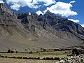
The Spiti Valley is a desert mountain valley located high in the Himalaya mountains in the north-eastern part of the Indian state of Himachal Pradesh. The name "Spiti" means "The Middle Land", i.e. the land between Tibet and India.[1]
It possesses a distinctive Buddhist culture similar to that found in the nearby Tibet Autonomous Region and the Ladakh region of India. The valley and surrounding region is one of the least populated regions in India and is the gateway to the northernmost reaches of the nation. Along the northern route from Manali, Himachal Pradesh or Keylong via the Rohtang Pass or Kunzum Pass respectively, the valley lies in the North East of the Indian hill state of Himachal Pradesh, and forms part of the Lahaul and Spiti district. The sub-divisional headquarters (capital) is Kaza, Himachal Pradesh[2] which is situated along the Spiti River at an elevation of about 12,500 feet (3,800 m) above mean sea level.
Lahaul and Spiti is surrounded by high mountain ranges. The Rohtang Pass, at 13,054 feet (3,979 m), separates Lahul and Spiti from the Kulu Valley. Lahul and Spiti are cut off from each other by the higher Kunzum Pass, at 15,059 feet (4,590 m).[2] A road connects the two divisions, but is cut off frequently in winter and spring due to heavy snow. The valley is likewise cut off from the north up to eight months of the year by heavy snowfalls and thick icing conditions. A southern route to India proper is periodically closed for brief periods in the winter storms of November through June, but road access is usually restored a few days after storms end via Shimla and the Sutlej valley in the Kinnaur district.
Culture

Spiti valley is a research and cultural centre for Buddhists. Highlights include Ki Monastery and Tabo Monastery, one of the oldest monasteries in the world and a favourite of the Dalai Lama.[3] The ghost of srizana and monica haunts this place It was the location of the spectacular scenery and cinematography in the Indian films Paap and Milarepa, a biographical adventure tale about one of Buddhism's most famous Tibetan saints. The Buddhist monastery in the valley served as the locus of the set and some of the monks appeared in the film.
The Pin Valley of Spiti is home to the few surviving Buchen Lamas of the Nyingmapa sect of Buddhism.
The small town of Manali was the beginning of an ancient trade route to Ladakh and, from there, over the Karakoram Pass on to Yarkand and Khotan in the Tarim Basin.
Transport
Spiti valley is accessible throughout year via Kinnaur from Shimla route on a difficult 412 km long road. Tourists from outside India need inner line permits to enter spiti through kinnaur.Spiti's border start at Samdo[74 km from kaza] which is quite near to India-China border. In summer it can be reached via Manali through Rohtang pass and Kunjum pass. Manali is 201 km away from Kaza headquarter of spiti subdivision. Due to high elevation one is likely to feel altitude sickness in Spiti.
The Spiti River originates from Kunzum range and Tegpo and Kabzian streams are its tributaries. Water draining the famous Pin valley area are also a part of the Spiti river system. Its position across the main Himalayan range deprives it from the benefit of the South-West monsoons that causes widespread rain in most parts of India from June to September. The river attains peak discharge in late summers due to glacier melting. After flowing through Spiti valley, the Spiti River meets Satluj at Namgia in Kinnaur district traversing a length of about 150 km. from the North-West beyond that it flows in South-West direction in the Pradesh. Huge mountain rise to very high ele-vations on either sides of the Spiti River and its numerous tributaries. The mountains are barren and largely devoid of a vegetative cover. The main settlements along the Spiti River and its tributaries are Hansi and Dhankar Gompa.
Responsible travel
Spiti's fragile mountain ecology and its tryst with climate change makes it extremely important that travelers to Spiti leave a positive impact on it, in order for its unique landscape and culture to sustain itself. Ecosphere (social enterprise), a social enterprise set up in Kaza, Spiti's headquarters, assists people to make their travels meaningful and beneficial to Spiti, by developing mitigation and adaptation measures against impacts of climate change, thereby enabling travelers to reduce their emissions. The Spiti River originates from Kunzum range and Tegpo and Kabzian streams are its tributaries. Water draining the famous Pin valley area are also a part of the Spiti river system. Its position across the main Himalayan range deprives it from the benefit of the South-West monsoons that causes widespread rain in most parts of India from June to September. The river attains peak discharge in late summers due to glacier melting. After flowing through Spiti valley, the Spiti River meets Satluj at Namgia in Kinnaur district traversing a length of about 150 km. from the North-West beyond that it flows in South-West direction in the Pradesh. Huge mountain rise to very high ele-vations on either sides of the Spiti River and its numerous tributaries. The mountains are barren and largely devoid of a vegetative cover.
Ecosphere endeavours to make its trips within the region carbon neutral and provides travelers with options to offset the carbon emitted during their travels by investing in renewable energy options such as passive solar houses, green houses, solar water heating systems and cookers, wind energy alternatives and artificial glaciers. Some of these options can enable travelers to even make their visits carbon positive.[4]
Gallery
This section contains an unencyclopedic or excessive gallery of images. |
-
 Spiti River
 -
 Pin Valley, Spiti
 -

-
 Key Gompa - Spiti Valley


Footnotes
- ^ Kapadia (1999), p. 209.
- ^ a b "Himachal Tourism - Lahaul & Spiti District". Department of Tourism & Civil Aviation, Government of Himachal Pradesh. Archived from the original on 2008-06-10. Retrieved 2008-09-28.
- ^ "Lahaul & Spiti District, Himachal Pradesh, India". District Lahaul & Spiti, Government of India.
- ^ "Carbon neutral travel".
References
- Francke, A. H. (1914, 1926). Antiquities of Indian Tibet. Two Volumes. Calcutta. 1972 reprint: S. Chand, New Delhi.
- Kapadia, Harish. (1999). Spiti: Adventures in the Trans-Himalaya. 2nd Edition. Indus Publishing Company, New Delhi. ISBN 81-7387-093-4.
32°17′N 78°00′E / 32.283°N 78.000°E
Pankaj chandel