
Dhanushkodi
| Dhanushkodi தனுஷ்கோடி | |||
| — town — | |||
  | |||
| Coordinates | 9°09′07″N 79°26′45″E / 9.152011°N 79.445851°ECoordinates: 9°09′07″N 79°26′45″E / 9.152011°N 79.445851°E | ||
| Country | India | ||
| State | Tamil Nadu | ||
| District(s) | Ramanathapuram | ||
| Time zone | IST (UTC+05:30) | ||
| Area |
• 0 metres (0 ft) | ||
|
Codes
| |||


Dhanushkodi or Danushkodi (Tamil: தனுஷ்கோடி) is a town/village at the southern tip of Rameswaram island, on the eastern coast of the Tamil Nadu state of India.
Dhanushkodi is situated to the South-East of Pamban. Danushkodi is about 18 miles (29 km) West of Talaimannar in Sri Lanka. The Dhanushkodi railway line running from Pamban Station was destroyed in the 1964 cyclone and a passenger train with over 100 passengers drowned in the sea.
Hinduism
The Hindu scripture Ramayana says that the archer hero Lord Rama built a bridge or causeway, called Ram Setu or Rama's bridge, between the mainland and Sri Lanka, in order to bring his army across. After Rama won the war and crowned a new king of Lanka, Vibhishana, Vibihishana requested Rama to destroy the bridge. Rama broke the bridge with one end of his bow. Hence, the name Dhanushkodi or "end of the bow" (dhanush meaning bow and kodi meaning end). It is also said that Rama originally marked the spot for the bridge with one end of his famous bow. The series of rocks and islets currently found in a line between India and Sri Lanka suggests there was indeed a former land connection between India and Sri Lanka.[1]
Hindu pilgrims usually bathe in the ocean here before completing the pilgrimage to Rameswaram. The spot is considered a sacred confluence of two bodies of water: Mahodadhi (the Bay of Bengal) and Ratnakara (the Indian Ocean). In addition, it is said that pilgrimage to the holy city of Kashi in North India is not complete without also worshipping at Rameswaram, including the ritual bath at Dhanushkodi.
Geography
Dhanushkodi has the only land border between India and Sri Lanka which is one of the smallest in the world-just 45 meters in length on a shoal in Palk Strait. Before the 1964 cyclone, Dhanushkodi was a flourishing tourist and pilgrimage town. Since Ceylon (now Sri Lanka) is just 19 miles (31 km) away, there were many ferry services between Dhanushkodi and Talaimannar of Ceylon, transporting travellers and goods across the sea. There were hotels, textile shops and dharmashalas catering to these pilgrims and travellers. The Railway line to Dhanushkodi – which did not touch Rameswaram then and was destroyed in the 1964 cyclone − went directly from Mandapam to Dhanushkodi. Dhanushkodi in those days had a railway station, a small railway hospital, primary schools, a post office, customs and port offices etc. It was here in this island in January 1897, Swami Vivekananda after his triumphant visit to the west to attend parliament of religions held in USA in September 1893, set his foot on Indian soil from Columbo.
1964 cyclone
The area around Rameswaram has been frequently ravaged by several high-intensity cyclones and storms in the past. A scientific study conducted by the Geological Survey of India[2] indicated that the southern part of erstwhile Dhanushkodi Township facing Gulf of Mannar sank by almost 5 meters during 1948-49 due to vertical tectonic movement of land parallel to the coastline. As a result of this, a patch of land of about half a km in width stretching 7 km along North-South direction submerged in sea along with many places of worship, residential areas, roads etc. Incidentally, Tanjavur (Tanjore) Raja’s choultry, a known dharmasala for pilgrims in those days, located in this area, also submerged.
Before the 1964 cyclone, there was a train service up to Dhanushkodi called the Boat Mail from Madras Egmore (Now Chennai Egmore). The train would halt at a pier on the south-eastern side of Dhanushkodi township where a waiting steamer transported passengers to Sri Lanka across the Palk Strait [1]
The 1964 cyclone was unique in many ways. It all started with a formation of a depression with its centre at 5°N 93°E in the South Andaman Sea on 17 December 1964. On 19 December it intensified into a cyclonic storm. The formation of depression at such low latitudes as 5°N is rare in Indian seas though such cases of typhoon development within 5 degrees of Equator has been reported in North Western Pacific. The Rameswaram cyclone was not only formed at such low latitude but also intensified into a severe cyclonic storm at about the same latitude is indeed a rare occurrence. After 21 December 1964, its movement was westwards, almost in a straight line, at the rate of 400 km to 550 km per day. On 22 December it crossed Vavunia of Ceylon ( now called Sri Lanka) with a wind velocity of 280 km/h, moved into Palk Strait in the night and crashed into Dhanushkodi of Rameswaram island on the night of 22–23 December 1964. It was estimated that tidal waves were 7 metres high when it crossed Rameswaram. A scientific study of the cyclone by Shashi M Kulshreshta and Madan G Gupta is given at this link [2]
On that night (December 22) at 23.55 hours while entering Dhanushkodi railway station, the train No.653, Pamban-Dhanushkodi Passenger, a daily regular service which left Pamban with 110 passengers and 5 railway staff, was only few hundred yards before Dhanushkodi Railway station when it was hit by a massive tidal wave. The whole train was washed away killing all 115 on board. A few metres ahead of Dhanushkodi, the signal failed. With pitch darkness around and no indication of the signal being restored, the driver blew a long whistle and decided to take the risk. Minutes later, a huge tidal wave submerged all the six coaches in deep water. The tragedy that left no survivors, came to light only after 48 hours when the railway headquarters issued a bulletin based on the information given by Marine Superintendent, Mandapam.
The then Chief minister of Madras State (Now Tamil Nadu) M. Bhaktavatchalam who flew over the place, later reported that the tip of the engine was barely visible in water [3].[4][5] Incidentally, the disaster did not take place on Pamban bridge as is popularly believed now, but at Dhanushkodi end of Pamban island which is 28 km away from Pamban bridge. The Pamban bridge, connecting mainland of India to Rameswaram island, was too destroyed in the cyclone.
All together over 1800 people died in the cyclonic storm. All dwelling houses and other structures in Dhanushkodi town were marooned in the storm . The high tidal waves moved deep onto this island and ruined the entire town. Naval vessels sent to the relief and rescue of marooned people reported to have spotted several bloated bodies around the eastern end of Dhanushkodi. Eyewitness accounts recollected of how the surging waters stopped short of the main temple at Rameshwaram where many people had taken refuge from the fury of the storm. Following this disaster, the Government of Madras declared Dhanushkodi as Ghost town and unfit for living. Only few fisherfolks now live there.
Though the fatalities due to Rameswaram cyclone were less compared to 1977 Andhra Pradesh cyclone and the 1999 Orissa cyclone, in terms of wind velocity which touched 280 kph at Vavunia in Northern Sri Lanka on the evening of 22 Dec 1964 [6], the Rameshwaram cyclone is regarded as one of Asia's fiercest cyclone of 20th century.
In Dec 2004 just before the arrival of 2004 Indian Ocean tsunami that struck South India, the sea around Dhanushkodi receded about 500 metres from the coastline exposing the submerged part of the township for a while. This rare event was witnessed by the local fishermen.[7]
Memorial for Dhanushkodi Victims
A memorial erected near the Dhanushkodi bus stand reads as follows:
"A cyclonic storm with high velocity winds and high tidal waves hit Dhanushkodi town from 22 December 1964 midnight to 25 December 1964 evening causing heavy damages and destroying the entire town of Dhanushkodi"
Travel

Even though there was a railway line between Pamban and Dhanushkodi and a passenger train used to ply regularly, after the storm the tracks were damaged and in course of time, were covered by sand dunes and hence had to be abandoned. One has to reach Dhanushkodi either on foot along sea shore on the sand dunes or in jeeps and in tempos of fishermen.
There are several temples associated with Lord Rama around Rameswaram. It is advisable to visit Dhanushkodi in groups during the day and return to Rameswaram before sunset as the entire 15 km stretch is very lonely and scary but mystical.[citation needed] Tourism is budding in this area and a significant police presence to protect the visitors is there. Indian Navy has also set up a forward observation post to guard the sea. At Dhanushkodi one can see the deep and rough waters of Indian Ocean meeting the shallow and calm waters of Bay of Bengal. Since the sea is shallow here, one can walk into Bay of Bengal and witness the colourful corals, fishes, seaweeds, star fishes and sea cucumber etc.
At present, on an average, about 500 pilgrims visit Dhanushkodi daily and the number goes up by thousands during festival days, such as new and full moon days. Regular bus facility is available only up to a certain distance from Rameswaram via Kodhanda Ram Kovil (Temple) and many pilgrims who wish to perform religious rites at Dhanushkodi have to depend on private vans who charge anything between Rs80 and 100 per passenger depending upon the number of passengers and type of vehicle. Following the public demand of pilgrims who visit Rameswaram from all over the country, in 2003, Southern Railway sent a project report to Ministry of Railways for re-laying a 16 km new railway line to Dhanushkodi from Rameswaram. The planning commission was asked to look into the possibility of a new railway line between Dhanushkodi and Rameswaram instead of the earlier alignment from Pamban once again in 2010.[3] A new survey is likely during the 12th plan.[4]
At the "land's end" terminus of the peninsula to the southeast of Dhanushkodi, known as Arichumunai or erosion point, begins the chain of rocks and islets known as Rama's Bridge. These lead approximately 19 miles across the Palk Strait to Mannar Island on the northwestern tip of Sri Lanka. It is believed that this was an intact land bridge passable on foot until a cyclone in 1480 CE swept through the region and deepened the channel [5]
Solar eclipse:
Annular Solar Eclipse of 15th January 2010 was observed by many scientists and enthusiasts from this place.
Gallery
-
 The beach near Dhanushkodi Town. The metal road ends here.
 -
 The Beach near old Dhanushkodi Town. It's called Archal Munai in local tongue.
 -
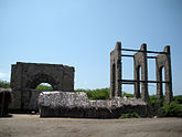 Remnants of the Dhanushkodi Railway Station
 -
 Wrecked fishing boat at Lands End, Dhanushkodi
 -
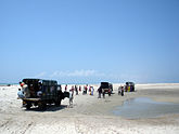 Mini trucks transport people to the Lands End, Dhanushkodi
 -
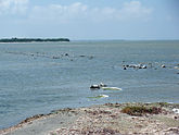
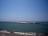 The sea from Land's End, Dhanushkodi. Sri Lanka is about 15 kilometers from here.
 -
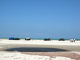 Mini Trucks take people to Land's End through deep sand and shallows using planks put under wheels by local kids as the vehicle struggles
 -
 The destroyed railway track - a storm and high tidal waves destroyed Dhanushkodi in 1964
 -
 Fishermen catching fish with their bare hands in the shallows
 -
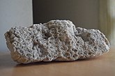 Floating Stone


See Also
References
- ^ "Adam's bridge". Encyclopædia Britannica. 2007. Archived from the original on 12 October 2007. Retrieved 2007-09-14.
{{cite web}}: Unknown parameter|deadurl=ignored (|url-status=suggested) (help) - ^ G. G. Vaz, M. Hariprasad, B. R. Rao and V. Subba Rao. Subsidence of southern part of erstwhile Dhanushkodi township, Tamil Nadu. CURRENT SCIENCE, VOL. 92, NO. 5, 10 MARCH 2007.Pg 671-672
- ^ http://www.hindu.com/2010/02/26/stories/2010022651500300.htm
- ^ http://www.asianage.com/india/poll-bound-tn-kerala-will-get-more-trains-754
- ^ Garg, Ganga Ram (1992). "Eve's Bridge". Encyclopaedia of the Hindu World. A-Aj. New Delhi: South Asia Books. p. 142. ISBN 81-7022-374-1.
External links
- Dhanuskodi- Life in a Ghost Town A Photo Essay
- American Meteorological Society, Volume 5, Issue 3 (June 1966) Satellite Study of the Rameswaram Cyclonic Storm of 20–23 December 1964, Shashi M. Kulshrestha and Madan G. Gupta, Indian Meteorological Service, New Delhi
- St. Petersburg Times - Dec 26, 1964
- Reading Eagle - Dec 28, 1964
- The Age - Dec 28, 1964
- The Hindu article on Dhanushkodi
- Advani visits Dhanushkodi
- Four-lane road planned for Dhanushkodi
- Submerged temple tower visible in Dhanushkodi
- Dhanushkodi still attracts tourists
- Hindu groups decry neglect of Dhanushkodi