
Southern Norway
Sørlandet ("south country") is the geographical region (landsdel) of the Skagerrak coast of southern Norway consisting of the two counties (fylker), Vest-Agder and Aust-Agder. The total combined area is 6368 sq. mi. or 16493 sq. km.
Origin and use of the concept
The name, and modern concept of this part of the country considered as a separate region, was introduced as late as 1902 by the local author Wilhelm Krag. Before this, the area was considered part of Vestlandet ("west country"). Sørlandet coincides roughly with the historic petty kingdom of Agder.
Occasionally, adjacent parts of the county of Rogaland and Telemark might be considered part of this region, as well.
If defined as an informal region, Sørlandet is perhaps more properly defined as the Skagerrak coastal belt, thus excluding the inland valleys to the north.
Coastal region
About 80% of the population of the two fylker live along the coast, which has the warmest climate as well as offering quick access to the rich fishing grounds and maritime roads of the Skagerrak. The coastal towns of Sørlandet, from west to east, are:
-
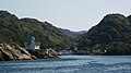 Kirkehavn on Hidra, Vest-Agder, Norway
 -
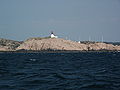 Lighthouse on Cape Lindesnes, Norway
 -
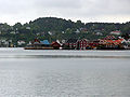 Arendal in Norway
 -
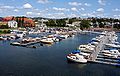 Kristiansand harbor


External links
- Southern Norway
- Agder
- Destination Sørlandet
- Tonal characteristics of some varieties of spoken South Norwegian.
This Agder location article is a stub. You can help Wikipedia by expanding it. |
This Agder location article is a stub. You can help Wikipedia by expanding it. |
| ||