
Setúbal

Setúbal (Portuguese pronunciation: [sɨˈtubaɫ] or [sɨˈtubɐɫ]) is the main city in Setúbal Municipality in Portugal with a total area of 172.0 km2 (66 sq mi) and a total population of 118,696 inhabitants in the municipality. The city proper has 89,303[1] inhabitants.
In the times of Al-Andalus the city was known as Shetúbar (Arabic: شَطُوبَر [ʃɛtˤuːbær]). In the 19th century, the port was called St. Ubes in English and St Yves in French.
The municipal holiday is September 15, which marks the date in the year 1860 on which King Pedro V of Portugal officially recognised Setúbal as a city.
City information

The seat of the municipality is the city of Setúbal, located on the northern bank of the Sado River estuary, approximately 40 kilometres (25 miles) south of Portugal's capital, Lisbon. It is also the seat of the Setúbal District.
In the beginning of the 20th century, Setúbal was the most important center of Portugal's fishing industry, particularly sardines. None of the many factories then created are operating today. However, the existing maritime ports, either traditional, commercial and the new marines, keep the city links to the ocean and water well alive and vibrant. Tourism, based on the beautiful existing natural conditions plus excellent hotels, resorts and infrastructures, is one of the city's most appreciated resources, due to its interconnection location with Sado (river) on one side and Atlantic Ocean on another, having a coast line with both. Also connected with the nearby coast of the Arrábida hills natural park - which offers an unspoiled nature and beautiful beaches to the Atlantic Ocean. A dolphin colony inhabits the Sado River. Across the river on the south bank lies the peninsula of Tróia, a place with vast white/golden sand beaches where several luxury hotels and resorts were recently built. The Tróia peninsula can be sighted from the city, across the river. Albarquel, Figueirinha, Galápos, Galapinhos and Portinho da Arrábida are some of the city's many beaches, located in the north bank of the estuary, at the very beginning of the Arrábida hills.
The main historical monument of the city of Setúbal is the Monastery of Jesus, with a 15th- and 16th-centuries church that represents one of the first buildings in the Portuguese late Gothic style known as Manueline.
Also of interest are the São Julião Church, also with Manueline portals. The Castelo de São Filipe, is a 16th- and 17th-centuries fortress on the north bank of the Sado river, overseeing the city. The fortress was converted into a luxury hotel (pousada).
Teatro Animação de Setúbal is based in Setúbal.
Demography (municipality)
| Year | 1801 | 1849 | 1900 | 1930 | 1960 | 1981 | 1991 | 2001 | 2011 |
|---|---|---|---|---|---|---|---|---|---|
| Population | 15,442 | 15,060 | 35,990 | 50,456 | 56,344 | 98,366 | 103,634 | 113,934 | 121,185 |
Economy
According to the census of 2011, the municipality of Setúbal had a labor force of 58,514 people, among whom 15.6% were unemployed. Among those who had a job, 1.6% were working in the Primary sector, 24.9% in the Secondary sector and 73.5% in the Tertiary sector.[2] Setúbal is notable for the industries of pulp, paper, cement, fertilizers, pesticides, other phytopharmaceutical products, thermal power, shipbuilding and ship repair. The Port of Setúbal had a cargo throughput of 6,058 tons in 2012,[3] making it the 4th busiest port in Portugal, with 7.4% of the cargo throughput in the country.[4]
Sports
The city's main sports club is Vitória de Setúbal, established on November 20, 1910.
Notable residents and citizens
- Diogo Fernandes Pereira, sometimes called simply Diogo Fernandes, was a 16th-century navigator. Diogo Fernandes was the first known European captain to visit the island of Socotra in 1503 and the discoverer of the Mascarenes archipelago ( Réunion, Mauritius, and Rodrigues) in 1507. He may also have been the first European to sail east of Madagascar island ('outer route' to the East Indies);
- Manuel Maria Barbosa du Bocage (1765–1805) : notable satirical and classical poet.
- Luisa Todi (1753–1833) : classical singer.
- José Mourinho : football manager.
- José Travassos Valdez, 1st Count of Bonfim (1787–1862) : soldier, politician, Prime Minister of Portugal
- José Vítor Moreira Semedo : footballer.
- Sabrina : represented Portugal at the Eurovision Song Contest 2007.
- Lima de Freitas (1927–1998) : Portuguese painter, illustrator, ceramicist and writer. He studied at the Escola Superior de Belas Artes de Lisboa. He illustrated over 100 books. Amongst his work on ceramic tiles, 14 Lisbon myths and legends tile panels are displayed at the Rossio Railway Station located at Rossio, Lisbon;
- Zeca Afonso (1929-1987) : singer and songwriter, lived and worked in the city in later life and died there.
- Mazgani : Luso-Iranian singer-songwriter.
- Sofia Vitória : singer.
- Luís Buchinho : fashion designer.
- Rui David : singer of Hands on Approach.
- Rogério Chora : Painter (a watercolor artist)
- Roy Campbell : poet, died nearby in a car accident.
International relations
Twin towns — Sister cities
Setúbal is twinned with:
|
Setúbal has international cooperation protocols with:
|
External links
Gallery
-
 16th-century fortress of St. Filipe.
 -
 São Julião Church in central Setúbal.
 -
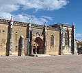 Monastery of Jesus of Setúbal (15th and 16th centuries).
 -
 Cruzeiro (a Stone cross) and façade of the Monastery of Jesus of Setúbal.
 -
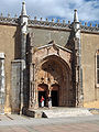 Main entrance to the Gothic-Manueline Monastery of Jesus of Setúbal.
 -
 A view of Setúbal's seaport.
 -
 Jardim Bonfim park.
 -
 Largo da Misericórdia.


References
- ^ UMA POPULAÇÃO QUE SE URBANIZA, Uma avaliação recente – Cidades, 2004 Nuno Pires Soares, Instituto Geográfico Português (Geographic Institute of Portugal)
- ^ Template:Pt icon "Municípios - Emprego e Mercado de Trabalho". PORDATA Base de Dados Portugal Contemporâneo. Retrieved 8 September 2013.
- ^ Template:Pt icon "2012-Estatísticas". Porto de Setúbal - APSS, SA. Retrieved 8 September 2013.
- ^ Template:Pt icon "INE: Porto de Lisboa perdeu 30% do movimento de mercadorias". Diário Económico. Retrieved 8 September 2013.
38°32′N 8°53′W / 38.533°N 8.883°W
Template:PortugalLargestCities Template:Portuguese urban areas of 50,000 population