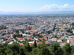
Serres
- This article is about the city in Macedonia (Greece). For other uses see Serres.
Serres (Greek: Σέρρες, older form: Σέρραι) is a city in the Greek region of Macedonia. Located at 41°05′08″N 23°32′59″E / 41.08556°N 23.54972°E, it is situated in a fertile plain at an elevation of about 70m, some 24 km northeast of the Strymon river and 69 km north-east of the Macedonian capital, Thessaloniki. The Rhodope Mountains rise to the north and east of the city.
The city is the capital of the eponymous prefecture of Serres and is situated in the Central Macedonia periphery. Its population was estimated at about 80,000 in 2001.
History
Known to the Romans as Serrae or Serrhae, Serres became the site of a major fortress built by the Byzantine Empire to guard the empire's northern frontier and the strategic Rupel Pass into Bulgaria. Defeated by the Bulgarians in the 10th century, it fell to Serbia in the 14th century and became a capital of Stefan Dušan, the Serbian tsar.
Serbian control was brief, however, as the Ottoman Empire captured Serres in 1383. In the early 20th century the city became a focus of anti-Ottoman unrest, which resulted in the Ilinden-Preobrazhenie Uprising of 1903.
A Bulgarian army captured Serres in the Second Balkan War of 1913, but was forced to withdraw by Greek forces. The city had to be completely rebuilt after being burned to the ground by the retreating Bulgarians. It was reoccupied by Bulgaria in both the First World War and Second World War and suffered further severe damage. Since the war, Serres has benefited from government-led programmes to develop its economy with foreign capital.
Economy
Serres is the capital of a primarily agricultural district and is an important trade centre for tobacco, grain, and livestock. Following the development of a government-sponsored manufacturing area in the late 20th century, it has also become a centre for the production of textiles and other manufactured items.
Sights and attractions
The city has forests, parks, non-gridded roads and squares. Serres stretches from the ruins of the castle up to the forested hills of Koula.
On the road to Koula hills on Exochon (Exochi) Street, two parks, one is the Agioi Anargyroi Park founded near the downtown area. Night clubs and cafeterias are popular attractions, especially in the summertime.
Sites of interest
- Public Regional Theatre (Δημοτικό Περιφερειακό Θέατρο/Dimotiko Perifereiako Theatro)

Serres has schools, lyceums, gymnasia, banks, a post office, a sporting centre, a train station, and squares (plateies).
Historical population
| Year | Population | Change | Municipal population | Change |
|---|---|---|---|---|
| 1981 | 46,317 | - | - | - |
| 1991 | 49,830 | 3,513/7.6% | - | - |
| 2001 | 55,000 | - | - | - |
Sporting teams
- Panserraikos - second division (2006-07 season) Website
External links
- Information about Serres (Greek and English)
- Information about Serres by the Municipality of Serres (Greek only)
References
- "Sérrai." Encyclopædia Britannica, 2006.
- "Sérrai, Siris, or Serres." The Columbia Encyclopedia, 2004.
