
St. Louis Gateway Mall

The St. Louis Gateway Mall in St. Louis, Missouri is a linear park one block wide running from the Gateway Arch at Memorial Drive to Union Station at 20th Street. It runs between Market Street and Chestnut Street.
History

Early History
The Mall began as part of the Comprehensive Plan of 1907, which embraced City Beautiful principles held by members of the City Plan Commission. That plan originally called for the removal of buildings between 13th and 14th streets from Clark north to Olive streets to form a new park mall. This didn't materialize and the very similar Central Traffic-Parkway plan was pushed in 1912. This hoped to clear buildings between Tucker and Jefferson in a one block wide trip between Market and Chestnut streets. A later phase of the project would have extended the mall as far as Grand Avenue. It had the support of Mayor Henry Kiel, but in a 1915 referendum on the plan, voters defeated it.
Another plan was released by the City Plan Commission in 1919. This one, the Public Building Plan, called for the clearing of buildings for a park space between 12th and 14th. The first section between 12th and 13th would go from Market north to Olive by the Central Library. The second, between 13th and 14th would be between Market and Chestnut. This was approved by voters in 1923 with an $87 million bond.
In 1939, as part of the Jefferson National Expansion Memorial, a park was built between 3rd and 4th streets between Market and Chestnut.
In 1940, the city constructed Carl Milles’ fountain The Meeting of the Waters on Aloe Plaza in front of Union Station.
In the 1950s, city leaders successfully completed the blocks between 15th and 18th streets.
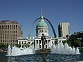
In 1965, voters approved a $2 million bond issue to build Kiener Plaza on the block between Broadway and 6th.
In 1966, after a voters defeated a demolition plan to extend the mall to Kiener Plaza the city moved forward regardless. One block between 10th and 11th streets was secured and was put into effect in 1976. It proved unpopular, and the block was redesignated as the site of Richard Serra’s sculpture Twain.
The Pride Plan
In 1982, mayor Vincent Schoemehl announced a public-private partnership called the Pride Redevelopment Corporation. The Pride plan was to remove the remaining buildings in the mall and construct smaller five-story buildings on the northern halves of each block to anchor park spaces on the southern halves. Three large historic office buildings, the Title Guarantee, Buder and International buildings, were pulled down by the end of 1984. The two years that followed showed the destruction of smaller historic buildings, known as Real Estate Row. All of these buildings were deemed eligible for the National Register of Historic Places by the National Park Service.
Only one half-block office building was constructed, the 15-story Gateway One. The building was criticized as encompassing the very qualities it was created to replace. It obstructed the view of the arch and it made the section of the mall on its block seem private and inaccessible.
In 1992, Schoemehl promised to complete the Mall before he left office, and in 1994, the two blocks between 8th and 10th streets were cleared for the mall, which removed the landmark Western Union Building.
The Master Plan
A master plan was commissioned for the mall in 2007 by mayor Francis Slay. It broke the mall up into a series of 'rooms' and called for the creation of a unifying hallway to run along the southern edge of the mall. Each room was to serve a function specific to the buildings adjacent to it. Next to the Serra sculpture, a sculpture park was called for. Next to the Library, City Hall, and the Civil Courts Building, a civic room to hold public events was recommended. Next to the Plaza Square apartment complex, a neighborhood room with family facilities was needed. At the end, by Union Station, there was a need to put some sort of end to the mall, and so a terminus section was designated. These rooms were intended to interact with each other and the buildings beside them.
Citygarden opened in 2009 to great acclaim. Citygarden was one of the rooms called for in the Mall's master plan. Following this, a conservancy group was formed to maintain the mall and carry out the rest of the objectives created by the master plan.
Luther Ely Smith Square
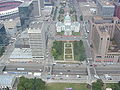
The Luther Ely Smith Square is controlled by the National Park Service, and located is directly between the Arch Grounds and the Old Courthouse. It is named after Luther Ely Smith who brought the arch competition to St. Louis.
Memorial Drive, which runs along Interstate 70 between the Gateway Mall and the Gateway Arch, has often been sighted by locals as having a pedestrian access problem. The current landscaping of the square, which focuses on symmetry, invites pedestrians to its edges away from its interior. It has been designated by the national park service as an orientation area and will see some changes in the near future.
As part of the new Framing a Modern Masterpiece design contest, the Square will probably be relandscaped, better connected to the arch grounds, and perhaps have an information kiosk. In the pre-competition design alternatives stage, it was suggested that the square could provide underground parking, food carts, and connect to two pedestrian bridges across the Interstate 70 divide.[1]
To the north is the Hyatt Regency St. Louis Riverfront. To the south are the Drury Plaza Hotel and KMOV-TV.
-
 Luther Ely Smith Square as seen from the Gateway Arch

Old Courthouse

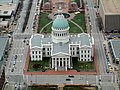
The Old St. Louis County Courthouse was a combination federal and state courthouse in St. Louis, Missouri that was Missouri's tallest habitable building from 1864 to 1894 and now is part of the Jefferson National Expansion Memorial.
Land for the courthouse was donated in 1816 by Judge John Baptiste Charles Lucas and St. Louis founder René Auguste Chouteau[2] Lucas and Chouteau required the land be "used forever as the site on which the courthouse of the County of St. Louis should be erected."[3] The Federal style courthouse was completed in 1828.
The courthouse was abandoned in 1930 when the Civil Courts Building was built. Descendents of Chouteau and Lucas sued to regain ownership. In 1935 St. Louis voted a bond issue to raze nearly 40 blocks around the courthouse in the center of St. Louis for the new Jefferson National Expansion Memorial. President Franklin Roosevelt declared in an Executive Order the area would be a national monument. The courthouse formally became part of the new monument area in 1940.
The roof was replaced in 1941 and rehabilitated again in 1955 and 1985.
The courthouse remained the largest structure in the monument until the Gateway Arch was built in 1965.
Notable cases
- In 1846 slave Dred Scott sued for his freedom in the building based on the fact that they had lived in free states. All of the trials including a Missouri Supreme Court hearing were held in the building. The case was to ultimately be decided by the U.S. Supreme Court in 1856 Dred Scott v. Sandford which ruled against him in 1856. The decision was to polarize sides in the run up to the American Civil War.
- In the 1872 Virginia Minor attempted to vote in a St. Louis election and was arrested. Her trials including the deliberations before Missouri Supreme Court were held in the building. The case was eventually appealed to the United States Supreme Court in Minor v. Happersett which upheld the male only voting rules.
-
 View of the Old Courthouse from the observation area at the top of the arch. Kiener Plaza is directly behind it.
 -
 Without the Ballpark Village the Courthouse can be seen from Busch Stadium
 -
seen from Busch Stadium
-


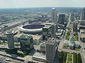
Kiener Plaza

Kiener Plaza is north of the Hilton St. Louis at the Ballpark, and on the other side of that is the Ballpark Village
In 2009, Architecture firm HOK offered a pro-bono plan to redesign Kiener Plaza.
-
 Kiener Plaza as seen from the arch in 2004
 -
 The Running Man in Kiener Plaza
 -
 The Running Man
 -
 sunken section of the Kiener Plaza


Gateway One

Built in the 1970s as a replacement for three historic structures that previously occupied the mall, Gateway One was built on the northern portion of the block with a park on the southern half. The original intention was to bring economic activity to the mall with several buildings built along the northern portions of blocks along the mall. Gateway One was the only building constructed in this way, and the park adjoining has taken on the quality of a private plaza instead of a continued portion of the Gateway Mall. Gateway One is the headquarters of Peabody Energy and has been criticised by many for the blandness of its design and its obstruction of the view.
To the north is the Wainwright Building. To the south is 700 Market Street.
-
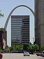 View of Peabody headquarters on the Gateway Mall.

Citygarden

Citygarden is an urban sculpture park donated by the Gateway Foundation in 2009 and includes art by many famous sculptors including: Donald Baechler, Tom Claassen, Jonathan Clarke, Niki de Saint Phalle, Jim Dine, Mark Di Suvero, Jean-Michel Folon, Laura Ford, Keith Haring, Fernano Leser, Aristide Maillol, Ju Ming, Igor Mitoraj, Julian Opie, Tom Otterness, Mimmo Paladino, Martin Puryear, George Rickey, Tony Smith, Bernar Venet, Kan Yasuda, and Jack Youngerman.
Richard Serra's Twain
This sculpture by Richard Serra dominates an entire block. It was designed specifically for the location intended to give viewers insights and perspectives as they walk around it. Previously in an undertrafficked green square by itself, plans are in the works to make it more accessible by the public and more connected to Citygarden.
To the north is AT&T Center and the Southwestern Bell Building. To the south is the Bank of America building and the KSDK TV and Cable Studios, south of that is the Thomas F. Eagleton Federal Courthouse.
-
![Igor Mitoraj's Eros Bendato exhibited in Poland, now resides in Citygarden.[citation needed]](//upload.wikimedia.org/wikipedia/commons/thumb/f/f3/Igor_Mitoraj_Eros_bendato_02.jpg/90px-Igor_Mitoraj_Eros_bendato_02.jpg) Igor Mitoraj's Eros Bendato exhibited in Poland, now resides in Citygarden.[citation needed]
Igor Mitoraj's Eros Bendato exhibited in Poland, now resides in Citygarden.[citation needed]
![Igor Mitoraj's Eros Bendato exhibited in Poland, now resides in Citygarden.[citation needed]](/wiki/File:Igor_Mitoraj_Eros_bendato_02.jpg)
Civil Courts Building

The Civil Courts Building (sometimes referred to as the St. Louis Pyramid) is a landmark court building used by the 22nd Judicial Circuit Court of Missouri in St. Louis, Missouri.
The building with its pyramid shaped roof is prominently featured in the center of photos of the Gateway Arch from the Illinois side as its location on the Memorial Plaza is lined up in the middle directly behind the Old Courthouse.
The building was part of an $87 million bond issue ratified by voters in 1923 to build monumental buildings along the Memorial Plaza which also included Kiel Auditorium and the Municipal Services Building. The Plaza and the buildings were part of St. Louis's City Beautiful plan.
It replaced the Old Courthouse as the city's court building and its construction prompted the descendents of the founding father Auguste Chouteau to unsuccessfully sue the city to get the Old Courthouse back since the stipulation was that it was to always be the courthouse.
The pyramid roof on the top was designed to resemble the Mausoleum of Maussollos which was one of the Seven Wonders of the Ancient World. It features 32 Ionic columns (8 on each side). Each of the columns have 6 fluted drums, and a cap, and are about 42 feet (13 m) high, 51⁄2 feet in diameter. They are made of Indiana limestone.[4]
The roof is made of cast aluminum and is topped by two 12-foot (3.7 m) high sphinx-like structures with the fleur-de-lis of St. Louis adorned on the chests. These sphinx-like creatures were sculpted by Cleveland sculptor, Steven A. Rebeck.[5]
To the south is the Mel Carnahan Courthouse
Civic Room

The Civic Room is made up of five blocks of green space surrounding Soldier's Memorial and the War Memorial. It is adjacent to the downtown Central Library. The Civic Room is planned to become a dominant space for outdoor festivals and events. Chestnut Street will be closed for three blocks to include a fountain and spaces for event tents. An outdoor stage has also been planned. It is bounded by 12th and 15th streets, Market, and Olive.
In the middle of the Civic Room is Soldier's Memorial Plaza. To the north of the Civic Room, is the Central Library, and the Washington Avenue Loft District beyond that. There is also the New Life Evangelistic Center and The Jefferson Arms apartments. To the south is the Peabody Opera House and City Hall.
Central Library
The Central Library, designed by Cass Gilbert, is set apart from the Civic Room across Olive Street.
Soldiers Memorial
Soldiers Memorial is an island surrounded by the Civic Room.
Peabody Opera House
The Peabody Opera House is an anchor to this section of the mall and partial caretaker of its adjacent grounds.
-
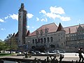
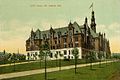 City Hall in 1907
 -
 The Peabody Opera House across Market


Neighborhood Room
Currently made up of two blocks, the Neighborhood Room will be between 15th and 18th streets. Adjacent to the residential Plaza Square apartments and the downtown post office, this section of the mall is to be one of primarily residential usage with sand-volleyball courts and youth soccer fields.
To the north is Plaza Square, a 1960s apartment complex. To the south is the Abrams Federal Building and the St. Louis Post Office
-
 The Neighborhood Room as it appeared in the fall of 2005.
 -
 looking down Market from 18th street.
 -
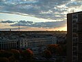
 looking down Chestnut at dawn from 17th street.
 -
 the Post Office as seen from a balcony in Plaza Square


Terminus
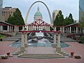
The terminus extends from 18th Street west to the I-64 exit ramps. It includes Aloe Plaza and the Carl Milles fountain, The Meeting of the Waters. The fountain is a reference to St. Louis' place at the confluence of America's two great rivers, the Missouri and Mississippi. The western block in the Terminus is currently an inaccessible park, but in the master plan described as the site of a future observation mound similar to Monk's Mound in St. Louis' Metro-East.
To the south of the Terminus is Union Station.
Union Station
Union Station is mall built inside a converted railroad hub. There is a Marriott Hotel, a Hard Rock Cafe, a lake, and the MetroLink Union Station stop.
I-64 Interchange
In the original St. Louis highway plan, there was a plan for an additional north-south highway connecting to I-64. The interchange is there, but the highway is not. This space will be reclaimed by the NorthSide project as a job center. It should have a new boundary at 22nd Street.
-
Phase 1 of the NorthSide TIF plans a redevelopment of the I-64 interchange at the Terminus
-
 Union Station across Market from the Milles' fountain on the Gateway Mall

References
- ^ Jefferson National Expansion Memorial General Mangement Plan Redevelopment Alternatives
- ^ The NPS site says the donation was from "Auguste Chouteau." Several members of the Chouteau clan have that name. It could also mean Auguste Pierre Chouteau.
- ^ Old Courthouse Architecture - nps.gov - Retrieved January 8, 2008
- ^ "Civil Courts Building - St. Louis, Missouri" Waymark - waymarking.com - Retrieved January 11, 2008
- ^ Opitz, Glenn B. Dictionary of American Sculptors: 18th Century to the Present. Poughkeepsie, NY: Apollo Books, 1984, page 329.