
Talk:Control of cities during the Syrian civil war
| This is the talk page for discussing improvements to the Control of cities during the Syrian civil war article. This is not a forum for general discussion of the article's subject. |
Article policies
|
| Find sources: Google (books · news · scholar · free images · WP refs) · FENS · JSTOR · TWL |
| Archives: Index, 1, 2, 3, 4, 5, 6, 7, 8, 9, 10, 11, 12, 13, 14, 15, 16, 17, 18, 19, 20, 21, 22, 23, 24, 25, 26, 27, 28, 29, 30, 31, 32, 33, 34, 35, 36, 37, 38, 39, 40, 41, 42, 43, 44, 45, 46, 47, 48, 49, 50, 51, 52, 53, 54, 55, 56, 57, 58, 59, 60, 61, 62, 63, 64, 65Auto-archiving period: 7 days |
| This page is not a forum for general discussion about Control of cities during the Syrian civil war. Any such comments may be removed or refactored. Please limit discussion to improvement of this article. You may wish to ask factual questions about Control of cities during the Syrian civil war at the Reference desk. |
| This article is of interest to the following WikiProjects: | |||||||||||||||||||||||||||||||||||||||||||||
Please add the quality rating to the {{WikiProject banner shell}} template instead of this project banner. See WP:PIQA for details.
Please add the quality rating to the {{WikiProject banner shell}} template instead of this project banner. See WP:PIQA for details.
| |||||||||||||||||||||||||||||||||||||||||||||


.svg)
| To help centralise discussions and keep related topics together, Template talk:Syrian Civil War detailed map redirects here. |
Template:Syrian Civil War sanctions
|
Index 1, 2, 3, 4, 5, 6, 7, 8, 9, 10 |
|
This page has archives. Sections older than 7 days may be automatically archived by Lowercase sigmabot III when more than 4 sections are present. |
Syrian Army captured more Towns in North Hama
Syria TV report with subtittles. https://www.youtube.com/watch?v=5wx-VBCu4X0 — Preceding unsigned comment added by 190.203.137.34 (talk • contribs) 21:41, 3 October 2014
Al Qaeda is in All Green Towns
All Qaeda is in All Green Towns not only in Idlib Towns
The so called Islamic Front Was created by Al Qaeda member Abu Khaled al-Suri he was killed by the ISIS http://www.cbc.ca/news/world/syria-suicide-bombers-kill-al-qaeda-rebel-leader-in-aleppo-1.2548340
Even if you don't consider the islamic front as part of AQ, the nusra which is cleARLY AQ is in the vast majority of green areas.
SHouldn't a grey dot be put then within most of the greens (if it can be documented)? That could be used to show they are working together.
If hezbollah is the main garrison in any government town, I would understand putting a yellow dot within the red. Although I think they are primarily focused in a few areas, from what I've read.
— Preceding unsigned comment added by 72.252.161.166 (talk • contribs) 23:39, 13 November 2014
Menagh & northern Aleppo
A frightening situation , this article explains that FSA has withdrawn from Menagh and Nursa has taken control of this. It says fighting between Nusra and FSA has moved to Aleppo’s countryside. So it is not just in Idlib countryside now. http://www.al-monitor.com/pulse/originals/2014/11/jabhat-al-nusra-idlib-islamic-emirate.html — Preceding unsigned comment added by 72.252.161.166 (talk • contribs) 20:54, 13 November 2014
- Dozens of fighters from Jabhat al-Nusra pledged allegiance to the IS northeast of Aleppo.SOHR — Preceding unsigned comment added by Hanibal911 (talk • contribs) 21:25, 14 November 2014
Jaz'ah
According to SOHR's report http://syriahr.com/en/2014/11/7-militants-died-in-clashes-with-ypg-in-ras-al-ayn/ 2 villages(Mestriha and Felastin) south of Jaz'ah should be contested. — Preceding unsigned comment added by Saeed alaee (talk • contribs) 06:39, 18 November 2014
There we Go Again ...
And again we have pro-SAA editors change the Daraa and Quneitra map towards their own views without sources. I want the following questions answered with neutral sources:
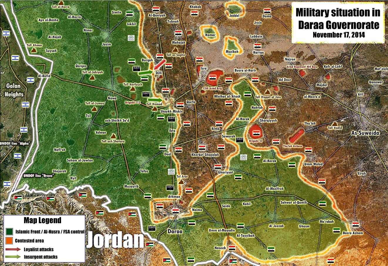
1. Why was Dilli changed back to red and why is the 60th Engeneering Regiment nearby deleted as a green army base dot? 2. Why is the green circle around Mahajjah deleted, whilst SANA itself says there were bombings there, so rebels nearby? 3. Why is the city of Bosra changed from contested to red without a neutral source given? 4. There is a grey JaN ring in Nawa, whilst there is no infighting in southern Syria. So why the grey ring?! 5. Why is Tell Antar contested? No sources given
And before people start bombarding this post with PetroLucum or Al-Masdar stuff, I mean neutral sources. Al-Minotor wrote an article which states Sheikh Maskin and Brigade 82 should be green, as well as many towns north of it. We ignored it based on Al-Masdar reports (could as well listen to SANA). So, if that's the case, I will use Twitter sources from opposition activistst to change towns to green, since that is what pro-SAA people here do to contested and rebel towns in the south. — Preceding unsigned comment added by 84.24.43.183 (talk • contribs) 08:52, 19 November 2014
1- Dilli needs to be contested. The rebels took it, the regime counter-attacked and now clashes are happening inside the village. You used a totally pro-regime source to change it back to red. Also, SOHR reported 60th Batallion to be on rebel hands, so put it back(it's a small base, so maybe use a checkpoint icon).
2- Add the Daara Central Prison back, as it was AGAIN excluded. This is getting really boring.
— Preceding unsigned comment added by 179.183.246.229 (talk • contribs) 11:15, 19 November 2014
Al-Nusra in Dar'a and Quneitra
According to many reports, there is a steady presence of al-Nusra in the Dar'a and Quneitra governorates, controlling a significant number of villages. Some say that they cooperate with the Syrian Opposition in this area (Islamic Front and SRF), but they still form a separate and distinctive force. GreyShark (dibra) 17:04, 25 December 2014 (UTC)
- Nusra doesn't control a single individual village and town in Daara/Quneitra. They share control of many towns, such as Nawa, but does not fully control village or town. Also, they are currently fighting a Free Syrian Army faction, the Yarmouk Army, accusing the FSA-linked brigade of having pledged obedience to the Islamic State, which the brigade denies. The fighting however is limited to a few towns, and the other Free Syrian Army factions, along with independent Islamic Brigades and some Islamic Front groups, are against the infighting between those groups, which stop us from changing some towns to contested between Nusra and FSA, since most factions of the Free Army are still working with both sides on the southern inter-insurgency conflict. I believe to maintain those towns Green unless the fighting between the Free Syrian Army and Nusra expands to another factions. — Preceding unsigned comment added by 200.219.152.90 (talk) 20:29, 25 December 2014 (UTC)
- Not precise - for according to Al-Monitor [1], Beit Jan is controlled by FSA, while Mazraat Beit Jan is by Al-Nusra. In many cases, JAN control specific villages, though they do keep a cease fire with FSA and Islamic Front factions in the region.GreyShark (dibra) 21:03, 31 December 2014 (UTC)
- The villages are of course in Quneitra and Riff Dimashq accordingly, but they are adjacent to each other.GreyShark (dibra) 21:04, 31 December 2014 (UTC)
Some missing military sites
Greetings. I believe it is important to add some missing military sites to add strategic depth and importance to certain areas.
- For example this is Brigade 13 near Dimas area (that was bombed by Israel some time ago): http://wikimapia.org/25789288/Army-Terrain
- Or this Air Defense Base overlooking Madaya, some say it is the Hosh Checkpoint bombing Zabadani: http://wikimapia.org/25740332/ar/ممكن-حاجز-الحوش؟
- Here the regiment/brigade 14 near Nabek http://wikimapia.org/24864101/Army-Base
- This air defense base overlooking 2 VITAL highways: http://wikimapia.org/25972814/Air-Defense-Base
- This SAA outpost near the border crossing: http://wikimapia.org/31776572/Syrian-Army-outpost
Many many more sites can be found on Wikimapia showing SAA presence in numerous areas that seemingly lack this presence. The desert for example is not as empty as we may have thought. ChrissCh94 (talk) 17:53, 28 December 2014 (UTC)
- Agree! Also all government and opposition source showed that these area where located these objects under control by army. We need to man up map. Hanibal911 (talk) 18:23, 28 December 2014 (UTC)
- I know they sit well inside Gov-territory but they do help the map in a strategic way, they show the border is not defenseless, East/West Qalamoun not totally connected etc...
- Feel free to add any other SAA site you think adds strategic depth to our map. ChrissCh94 (talk) 18:38, 28 December 2014 (UTC)
- We need add those military sites. Hanibal911 (talk) 18:57, 28 December 2014 (UTC)
- Also maybe we need also add some border posts in Dara province which located near of the Jordanian border to east from Nassib border crossing.hereherehereherehere Because pro government here and pro opposition archiciviliansarchicivilians sources clear showe that this area still under control by army. Hanibal911 (talk) 19:07, 28 December 2014 (UTC)
- We need add those military sites. Hanibal911 (talk) 18:57, 28 December 2014 (UTC)
- Agree because it shows that the Eastern Jordanian border is not open to men/weapons such as the west. ChrissCh94 (talk) 20:17, 28 December 2014 (UTC)
- Also some hamlets Abu RasAl-Mashafi, Jordanian-Syrian Joint Industrial Free Zone and Sheikh Khader Zubi Farm which located in area near Nassib border crossng which still under control by army. Pro government here and pro opposition archiciviliansarchicivilians sources clear showe that this area still under control by army. Hanibal911 (talk) 17:14, 29 December 2014 (UTC)
- If we're adding minutia to the map, unsourced minutia, then we need to do it evenly. We need to add under IS control all populated places between Raqqa and their holdings in Homs. We should add every tiny little farm as grey in Eastern Qalamoun. We should add the literally HUNDREDS of villages in Eastern Idlib province that between Abu al-Duhur and the Hama-Aleppo highway that are rebel held. Especially the Idlib towns - Eastern Idlib has HUNDREDS of villages that are way more populated and strategically important than the 2-building red dots you're proposing to add. Boredwhytekid (talk) 17:21, 29 December 2014 (UTC)
- You're proposing that we line the entire Jordanian border in red, when we all know it's porous. We can do that, sure, but if we're adding strategically important sites without sources, let's fill in all of our major blanks here, not just the pro-government ones. Idlib is entirely rebel held, essentially, and look at all the villages we're not showing - it's a huge blank spot on our map. If we're marking the entire Jordanian border red without sources, we need to fill this giant gap in as green... going by our map you'd think Sinjar is the only populated place in eastern Idlib. It's a gross misrepresentation. Boredwhytekid (talk) 17:24, 29 December 2014 (UTC)
- BoredwhytekidOk! Now I remove from the map Sheikh Khader Zubi Farm and Abu Ras, Al-Mashafi hamlets but I left on map a border posts which I earlier add and Industial zone. Hanibal911 (talk) 17:44, 29 December 2014 (UTC)
- You're proposing that we line the entire Jordanian border in red, when we all know it's porous. We can do that, sure, but if we're adding strategically important sites without sources, let's fill in all of our major blanks here, not just the pro-government ones. Idlib is entirely rebel held, essentially, and look at all the villages we're not showing - it's a huge blank spot on our map. If we're marking the entire Jordanian border red without sources, we need to fill this giant gap in as green... going by our map you'd think Sinjar is the only populated place in eastern Idlib. It's a gross misrepresentation. Boredwhytekid (talk) 17:24, 29 December 2014 (UTC)
I'm not against Sheikh Khader Zubin Farma nd Abu Ras, al-Mashafi hamlets going on the map - they are SAA held, no doubt about it, and they should be added. I think we should add them, AND sites in Idlib, AND the IS pathway to Hama province. Let's get all 3 done while we're in this consensus spirit of fixing our evident mistakes though without sources.
- Not to come off as pro-op, but we're missing so many rebel-held sites in Idlib that it's disgraceful. The whole province is out of SAA hands except the corridor Jish Shugur to Idlib city. There are TONS of towns in east Idlib around Sinjar that we could/should add - because right now our map shows that area as unpopulated/no rebel presence.. though it's heavily populated and all rebel held. Boredwhytekid (talk) 18:06, 29 December 2014 (UTC)
- Boredwhytekid About the Idlib province, I agree with you. Also reliable source clear said that Front Al Nusra and a number of Islamist militias, along with a small number of FSA groups, now controlled between 70 and 80 percent of Idlib province.The Daily Star But according to the source FSA and moderate rebels have a small presents in Idlib province. So maybe we need add villages to under control of Al Nusra. Also another source said that Al-Nusra to liquidate the Syria Revolutionaries Front and expel Jamal Maarouf from Idlib province in October. Within two months, Jabhat al-Nusra has achieved a level of progress that Maarouf did not achieve during two years of operations against the two camps. This may create a further favorable environment for Jabhat al-Nusra in the region. By completing its control over the countryside of Idlib, from the north to the south, Jabhat al-Nusra will have expanded the limits of the emirate which Al Nusra intends create.Al Monitor Hanibal911 (talk) 18:34, 29 December 2014 (UTC)
- Here - I didn't go crazy adding towns, just enough to keep it proportionate with the SAA ones in Daraa. A few green dots to fill in the gaps in Idlib province, and a few black dots to show the IS transit route southwest to Hama and from Raqqah south to the al-Taybah region. Boredwhytekid (talk) 18:51, 29 December 2014 (UTC)
- Hanibal911, I added the Idlib towns in green for the time being, if for no other reason than that so far JAN's stronghold seems to be tighter in Western Idlib than Eastern Boredwhytekid (talk) 18:53, 29 December 2014 (UTC)
- Here - I didn't go crazy adding towns, just enough to keep it proportionate with the SAA ones in Daraa. A few green dots to fill in the gaps in Idlib province, and a few black dots to show the IS transit route southwest to Hama and from Raqqah south to the al-Taybah region. Boredwhytekid (talk) 18:51, 29 December 2014 (UTC)
- Boredwhytekid I knew you were going to disagree. Not accusing you of being biased but it was expected. I suggested adding those sites because they are not random. They show the Homs-Baghdad road is under regime control (since roads aren't illustrated here), they show that Eastern Qalamoun isn't fully connected to its Western counterpart. And finally it shows that the Eastern Jordanian border isn't as porous as the Western one, where most rebel gains are located. The sites I suggested should be added not to show increased regime strength but to illustrate several points. I am not against adding rebel sites, in fact if you look up in earlier archives I was the one who suggested adding the rebel held bases in western Aleppo especially the Khan Al Assal police academy where hundreds died in the battle there. So Hanibal911 don't add random SAA sites, just add those few 4-5 sites I provided in my first post in this section. And if Boredwhytekid has more suggestions concerning rebel-held bases we are listening ^^ Cheers. ChrissCh94 (talk) 01:26, 30 December 2014 (UTC)
- Boredwhytekid About the Idlib province, I agree with you. Also reliable source clear said that Front Al Nusra and a number of Islamist militias, along with a small number of FSA groups, now controlled between 70 and 80 percent of Idlib province.The Daily Star But according to the source FSA and moderate rebels have a small presents in Idlib province. So maybe we need add villages to under control of Al Nusra. Also another source said that Al-Nusra to liquidate the Syria Revolutionaries Front and expel Jamal Maarouf from Idlib province in October. Within two months, Jabhat al-Nusra has achieved a level of progress that Maarouf did not achieve during two years of operations against the two camps. This may create a further favorable environment for Jabhat al-Nusra in the region. By completing its control over the countryside of Idlib, from the north to the south, Jabhat al-Nusra will have expanded the limits of the emirate which Al Nusra intends create.Al Monitor Hanibal911 (talk) 18:34, 29 December 2014 (UTC)
I'm all for adding the bases - I just proposed filling in Idlib a bit when other SAA sites starting going up, like farms and industrial sites. Also not against those either though. Just wanted to fill in Eastern Idlib a little and the same for the IS corridor to Hama. Both also add realism/strategic depth to the map, because they are known areas of control that up til now we have not accurately shown. We still need to sprinkle in a few dots between Abu al-Duhur and the Aleppo road too - still a major blank spot on our map, shown as rebel held on every other map. There are not bases, or even specific sites, but the area is littered with rebel villages and yet by glancing at our map you'd think it's an unoccupied desert. Boredwhytekid (talk) 13:53, 30 December 2014 (UTC)
- According to data from Joshua landis al Nusra controlled 5% territory in Syria and the moderate rebels also now controlled nearby 5% territory in Syria. So that according to those data we need be careful when we add the cities or villages under rebel control of rebels or Al Nusra. Hanibal911 (talk) 14:12, 30 December 2014 (UTC)
- Can you find a single map that does NOT show that area as rebel held? desyracuse, archicivilians, political geography now, Carter center, wikicommons.. Seriously though, can you find one that shows that area in anything but green? The SAA firmly holds the highway to Aleppo. The countryside to the west of the highway has been rebel held, and shown as such on every map but ours, for 2 years. On our map we show it as an empty desert though. Boredwhytekid (talk) 14:38, 30 December 2014 (UTC)
- Boredwhytekid OK Agree! But then we also need add some towns and villages in the сentral and south parts the Latakia province because we all know that those areas is completely under control by army and in Tartus province which is fully under control by army. And how I earlier said we need more in details research the situation in the Idlib province where according to data from many reliable sources of Al Nusra controls much of the province after they expelled from province SRF (Syrian Revolution Front). Hanibal911 (talk) 15:16, 30 December 2014 (UTC)
- Can you find a single map that does NOT show that area as rebel held? desyracuse, archicivilians, political geography now, Carter center, wikicommons.. Seriously though, can you find one that shows that area in anything but green? The SAA firmly holds the highway to Aleppo. The countryside to the west of the highway has been rebel held, and shown as such on every map but ours, for 2 years. On our map we show it as an empty desert though. Boredwhytekid (talk) 14:38, 30 December 2014 (UTC)
No, we're going 1-for-1-for-1, if anything, or nothing. The unsourced but accurate SAA sites on the Jordanian border and the unsourced but accurate rebel control in Eastern Idlib and the equally unsourced but accurate IS corridor from Raqqah to Hama. All 3 have strategic importance, and by doing all 3 no one can be accused of bias because we'll be bending the rules equally for all sides while not compromising the integrity of the map. Central/southern Latakia and Tartus are #1 irrelevant because we already show both provinces SAA held, and #2 inappropriate because that'd be 2 locations for the SAA and only 1 each for rebels and IS. Boredwhytekid (talk) 15:24, 30 December 2014 (UTC)
- ChrissCh94, André437, DuckZz, Alhanuty - Yay or Nay? My opinion is that all 3 unsourced additions - red, lime, and black - improve the map. But I'm only signing up to the idea if we do all 3, if we this one time break the rules evenly for all sides, to improve the map in all 3 cases.Boredwhytekid (talk) 15:33, 30 December 2014 (UTC)
- Boredwhytekid OK! It be correct to add some villages in the Aleppo province that would show that this region not empty and there also located villages which controlled by rebels! Hanibal911 (talk) 15:54, 30 December 2014 (UTC)
- Also I propose express your opinion about this and some other editors.XJ-0461 v2EkoGrafLindi29PaolowalterDaki122HCPUNXKID Hanibal911 (talk) 16:13, 30 December 2014 (UTC)
- But i think that we need remove black mark near Damascus - Baghdad highway,. Because this highway and surroundings still controlled by army.hereherehere But not one source not confirm that ISIS now control area near this highway. Or at least put this icon to the north of the highway. Hanibal911 (talk) 16:06, 30 December 2014 (UTC)
- Also I propose express your opinion about this and some other editors.XJ-0461 v2EkoGrafLindi29PaolowalterDaki122HCPUNXKID Hanibal911 (talk) 16:13, 30 December 2014 (UTC)
- Let's just remove that black mark. We have enough red dots to show the SAA controls the highway when it wants, but not too too many so it's clear enough that IS can jump over it to get to Bir Qassab if they really want to Boredwhytekid (talk) 16:16, 30 December 2014 (UTC)
- Hey guys i think we need put green semicircle near Menagh Air Base which is under control by Al Nusra but located inside area which is under control by moderate rebels. As you think? Hanibal911 (talk) 16:28, 30 December 2014 (UTC)
- Boredwhytekid OK! It be correct to add some villages in the Aleppo province that would show that this region not empty and there also located villages which controlled by rebels! Hanibal911 (talk) 15:54, 30 December 2014 (UTC)
Probably a good idea. I added some Idlib towns here. That's it. No more. Just enough to show the area is rebel held. Not trying to add every town or any nonsense like that. Everyone ok with this? It's unsourced so I'm asking for comments here, not trying to arbitrarily add anything. Boredwhytekid (talk) 16:45, 30 December 2014 (UTC)
- Agree! Hanibal911 (talk) 16:53, 30 December 2014 (UTC)
- Agreed but let's not exaggerate, adding army bases in Tartous/Suweida for example is useless. We agree on that. My suggestion was to fill the emptiness/wastelands/deserts with Strategic Bases/holding points. One example is the Khan Abu Shamat cement factory, yes it is one or 2 buildings but it controls the Baghdad Damascus Highway. Another example is Eastern Idlib. It is not a desert like Eastern Hama yet it appears empty. Add for example there the rebel-held Icarda Checkpoint on the M5-Highway [2]. Add the series of rebel-held villages overlooking the highway. But don't exaggerate. And Hanibal911 I insist you add the SAA-sites I mentioned in my first post. They are just 5 sites no big deal. But they do reveal important info. And if Boredwhytekid knows any more important rebel-held army sites, we could add them if they are strategically placed. ChrissCh94 (talk) 19:23, 30 December 2014 (UTC)
- Also those millitary objects located in area which under control by moderate rebel groups:
- Agreed but let's not exaggerate, adding army bases in Tartous/Suweida for example is useless. We agree on that. My suggestion was to fill the emptiness/wastelands/deserts with Strategic Bases/holding points. One example is the Khan Abu Shamat cement factory, yes it is one or 2 buildings but it controls the Baghdad Damascus Highway. Another example is Eastern Idlib. It is not a desert like Eastern Hama yet it appears empty. Add for example there the rebel-held Icarda Checkpoint on the M5-Highway [2]. Add the series of rebel-held villages overlooking the highway. But don't exaggerate. And Hanibal911 I insist you add the SAA-sites I mentioned in my first post. They are just 5 sites no big deal. But they do reveal important info. And if Boredwhytekid knows any more important rebel-held army sites, we could add them if they are strategically placed. ChrissCh94 (talk) 19:23, 30 December 2014 (UTC)
- Military college
- Army Fuelling Base
- Radar Base (Al Sha`allah) Hanibal911 (talk) 20:17, 30 December 2014 (UTC)
- Also I add Daraa Central Prison Hanibal911 (talk) 20:31, 30 December 2014 (UTC)
- Agreed on all of those except the radar base, is it ISIS or Rebel-held? And please Hanibal911 rename the SAA Army Base in Nabk Regiment 14, naming it this way gives it the military importance it holds. It is not an ordinary Army Base. And thank you for adding the rebel-held bases as well. I'm sureBoredwhytekid now agrees that the map is more accurate and remains fair. ChrissCh94 (talk) 22:17, 30 December 2014 (UTC)
- Also I add Daraa Central Prison Hanibal911 (talk) 20:31, 30 December 2014 (UTC)
- No objections here ChrissCh94. Please review the sites I added in Eastern Idlib - I'm not really familiar with the area. I tried to select sites spread out across the blank area on our map that they were intended to fill, so as to minimize the number added. If there are larger, more strategically important or appropriate sites that would serve the same purpose (filling that gap), we should identify them and replace the ones that were just chosen geographically. Boredwhytekid (talk) 23:20, 30 December 2014 (UTC)
- Frankly all I found was this Air Defense Base south of Abu l Duhur Airbase: [3]. I presume it is rebel-held.
- I also found this [4] west of AL-Safira, I don't know its current status (defunct or active) but I also guess it is rebel-held as well ChrissCh94 (talk) 23:47, 30 December 2014 (UTC)
- Also I add those millitary objects located in area which under control by Syrian troops:
- Alright Hanibal911 please add those 2 rebel-held sites and that would be enough. [5] [6]. ChrissCh94 (talk) 11:30, 31 December 2014 (UTC)
- I already added those bases.here Hanibal911 (talk) 13:02, 31 December 2014 (UTC)
- Alright Hanibal911 please add those 2 rebel-held sites and that would be enough. [5] [6]. ChrissCh94 (talk) 11:30, 31 December 2014 (UTC)
Who and what controls in Syria
Moderate rebels are no longer one of the major players in the Syrian conflict! The four strongest authorities in Syria are the Assad government, ISIS, Nusra, and the Kurds. They rule close to 95% of Syrian territory:
- Syrian government rules 45% of the land and perhaps 65% of the population, give or take.
- ISIS rules 35%, but controls less than 3 million people.
- Kurds may control about 8% or 9% of Syria.
- Al Nusra another 5% of Syria.
This leaves the hundreds of additional militias controlling the remaining 5%, but in some areas “No F.S.A. faction can operate without Nusra’s approval.” Jihadis prevailed in 2014.Joshua Landis Hanibal911 (talk) 15:43, 29 December 2014 (UTC)
- So essentially, moderate rebels control 40-50% of rural Deraa and that is it? I was under the impression that they held more land. 2015 will be very interesting indeed. Who will seize the 35% of Syria when ISIS collapses, I wonder. XJ-0461 v2 (talk) 16:26, 29 December 2014 (UTC)
- All do to their failure to unite. Over 3 years of war, and they never truly united as a military force. The Southern Front aside, the SRF was the last biggest moderate conglomeration I'm aware of, and it's been obliterated as a large entity. Boredwhytekid (talk) 16:41, 29 December 2014 (UTC)
- I will add XJ-0461, that after a possible ISIS demise most of this terrain will become local fiefdoms and some of them will sworn allegience to the SAA, obviously looking for protection againt ISIS.200.48.214.19 (talk) 13:24, 30 December 2014 (UTC)
There biggest mistake was getting into bed with jihadi groups which lost them support outside Syria and inside . There only hope now must be in a peace deal that gives them some say in running the country ,as for the jihadists the war goes on until the government and moderates are defeated .81.156.224.243 (talk) 18:21, 29 December 2014 (UTC)
Pre-Kobane siege pro-kurdish outlet welati claimed areas controlled by kurds had a population of 3.5 millions, pre-Kobane numbers could probably be way closer to 2 million however, have to search a bit more of info on the matter.
179.32.121.230 (talk) 18:31, 29 December 2014 (UTC)
While reading his previous articles I had a meaning that Joushua Landis has some menthal problems, while he suddenly posts something unrelated .. i can't remember now but he often used words such as "monkey, rats, gorilaz" describing rebels in Syria. I think his wife comes from Latakia, that could be the reason, nevertheless i always think he's a propagadna writer, nothing more, but this is just my opinion. DuckZz (talk) 22:32, 29 December 2014 (UTC)
SOHR said two weeks ago that government don't control more than 30 % of Syria anymore... The numbers of the beginning of this discussion are I believe quiet biased... I agree with the fact that moderate rebels do not control much of the ground but if you consider the territory still held by the Shamia Front in Aleppo, in Idlib, as long with the ground held by the Southern Front, and the Islamic Front in Damascus contryside, the more or less moderate military opposition forces are still a player on the ground that could rise from the ashes of the current Syria in the years to come of this ongoing war... Two years ago, who would have believed that ISIS would have taken that much ground today ? I think burying anyone now would not be serious at all.Oussj (talk) 19:15, 30 December 2014 (UTC)
- SOHR is no longer a reliable source, look at their main logo a FSA flag. Is there another proof necesary for their biased opinion.200.48.214.19 (talk) 13:57, 31 December 2014 (UTC)
- I have long found that Landis makes very superficial reports on Syria. (I've mostly seen his videos.) He plays the role of "expert" in interviews, being an academic that supposedly focuses on Syria. But he is probably less well informed than most of us, with a bias consistently underestimating moderate rebels. Although it is probably true that many small moderate rebel groups are intimidated by al-Nusra, they do control territory that al-Nusra would be unable to control themselves. In Daraa, it is only the reluctance of the dominant FSA to turn al-Nusra into an enemy instead of an ally that leaves them as a force there. And it is similar in Aleppo city, with the recent alliance of the 5 largest groups, 4 FSA and one moderate IF group. If the Islamic Front is considered moderate (they are closer to the FSA than to any other group), 5% control is ridiculous. FSA and IF groups together in Aleppo province alone probably control more than 5% of the country, and another 5% in Daraa and Quneitra. Not counting control in Idlib, Homs, and Damascus provinces. Which is certainly not all al-Nusra.
- I would take Landis reports with a few kilos of salt.
- I would also note that the regime controls 0% of the 1/3 of the population which fled the country, probably dominantly pro moderate rebel. As well as noting that many fled to regime controlled areas to escape regime bombardment targeting civilian populations in other areas. Not because they were attracted by regime terrorism. (Or systematic gross human rights violations and war crimes, using the terminology of the UN.) André437 (talk) 06:36, 1 January 2015 (UTC)
Jordanian border
Can somebody who edited red dots and checkpoints all along the eastern Jordanian border in Daraa province give his/her sources? There has been no discussion here, but there have been edited some three border checkpoints, two red villages and the industrial zone near Nasib. Sources?
- Pro opposition source ArchiciviliansArchicivilians clear show that this area to east from Nassib border crossing still under control by army. Hanibal911 (talk) 18:39, 29 December 2014 (UTC)
On this page the discussion is here Boredwhytekid (talk) 18:45, 29 December 2014 (UTC)
Hanibal911 .A editor has taken them of map .Vandalism .86.141.225.40 (talk) 10:16, 1 January 2015 (UTC)
- If I'm looking at the correct edit, it's not vandalism, check the history of the Module in future before claiming vandalism. Revert was done by the person who originally made this map because the source (Wikimapia) is unreliable. See User talk:Hanibal911#Military bases added based on name in Wikimapia. — Preceding unsigned comment added by John Smith the Gamer (talk • contribs) 16:06, 1 January 2015 (UTC)
How do you evaluate the year of 2014 in Syria (and even Iraq) ?
I mean: Who won in long term, who lost power. What were the major terriorial changes in this year? What do you expect in 2015 ? What do you think about the rise of ISIS in the eastern parts of Syria and half of Iraq and the rising of Al-Nursa "emirate" in Idlib ? Do you think that the "moderate" rebels will play any role in the future (Failure or succes of the American foregin policy) ? Do you think that the Assad-goverment will collapse sooner or later in long term (lack of manpower)? You can share your own toughts or send some professional analisis (with links of course). — Preceding unsigned comment added by Oroszka (talk • contribs) 18:02, 29 December 2014 (UTC)
- In terms of job security, Assad has never been safer since the start of the uprising. The "moderate" rebels are on their last legs and ISIS and JAN do not care about overthrowing him, only expanding. In Idilb, they have lost all territory and they have become puppets in Aleppo. The only place they are truly relevant is the south, which brings me to a discussion on Eastern Ghota. That pocket of rebel resistance is also on its last legs, and will probably not survive this winter. There are 20-25k pro-gov forces besieging the place. When the fight is over, they will flood the southern front, giving the moderate rebels a real issue to deal with. As for the government's lack of manpower, that has be touted since 2012, and nothing has come of it, so I do not give it much thought. The real wild card is ISIS. It is an unstable entity that holds 35% of Syria. When it collapses, the final outcome of the war will emerge in my own opinion. XJ-0461 v2 (talk) 19:30, 29 December 2014 (UTC)
- Victors by Governate for 2014:
Raqqa: ISIS victory
Deir-Ez-Zor: ISIS victory over rebels /SAA victory over ISIS
Hasaka: YPG-SAA victory
Homs: Major SAA victory
Hama: SAA victory
Aleppo: Major SAA victory
Latakia: SAA victory
Tartous: N/A
Swayda: N/A
Rif Dimashq: SAA victory
Qunietra/Derra: Major Rebel victory
Idlib: JAN victory
XJ-0461 v2 (talk) 19:29, 29 December 2014 (UTC)
I wouldn't say Hasaka is a YPG-SAA victory, yes, IS carried out several failed offensives but the first of these knocked out SAA from Regiment 121 and most of the southern countryside of the city, rest of frontlines save for Qamishlo South Front (YPG-SAA victories) have been more of a stalemate, with very little difference from the situation we had starting the year despite many offensives carried by all three parties.
Aleppo is also somewhat of a IS victory over rebels and YPG too since they got control of half of its northern countryside almost getting to Azaz while taking most of the Kobane countryside which YPG won't retake anytime soon if at all.
179.32.121.230 (talk) 20:10, 29 December 2014 (UTC)
Your analysis might seem credible if it wasn't for the "SAA victory over ISIS in Deir Ezzor". Being besieged in an airbase can in no way be interpreted as a victory. Anyways, the year 2014 was significant for many reasons. The rise of IS in eastern Syria is probably the biggest event to happen, followed by the tightening noose around Aleppo, as well as the rebel resurgence in the south. Other significant but less influential events include the Kobane media spectacle and anti-IS coalition conducting strikes in Syria, as well as the very recent fall of the Ma'arat al Nu'man SAA bases. The events in southern Idlib cast a shadow of doubt on the SRF: how come Al Nusra was able to come in and do what it did in one month that the SRF couldn't do in over a year? All of these events will continue to play out into 2015. In the south, the question is whether the rebels can push further and bring some relief to Ghouta, or if the so-called "Southern Front" will crack like the rebels have done in the north. Another question is how the rebels in Aleppo are going to maneuver: will they stick around and form another "Ghouta" or will they retreat ala Homs? IS is a big question all on its own, and all the questions we have are well known, the biggest one is whether the combined efforts of local and international belligerents will at least be able to slow them down. In Idlib, we are wondering whether central Syria is no longer a safe haven of the regime, and whether Al Nusra will be able to break the defensive line of northern Hama and push into the province. Of course these issues do not even encompass 50% of the war, and only a full paper could discuss everything. — Preceding unsigned comment added by 80.184.72.175 (talk) 21:39, 29 December 2014 (UTC)
Iraq [Late June] [Now] Yeah as a whole is generally bad for Everyone except ISIL until before June. Iraqi Government about the same as June, Kurds slight loss of ground since then, so ISIL has slight gains.
Syria [January 18th [Now Kurds: Massive loss of land around Kobane, slight loss in North East, little change North west.
Rebels: Loss of all land North East, not helped by Nusra truces with ISIL. Good progress in the south, have regained strong control of the border of the United Nations Disengagement Observer Force Zone, much to the worry of those who are pro-Israel, as well as those who fear Israeli involvement. Israeli strikes on Hezbollah shipments alleged provision of weaponry to rebel groups may have helped, though personally I believe Israel does not want the Assad regime to fall, as Assad has kept peace with Israel. Rebels have traded roughly evenly with the Regime around Hama, Homes and Aleppo, but have lost ground to ISIS around al-Alab.
Regime: As well as the above listed, after rebel buffers between it and ISIL fell, it has lost sparsely populated areas, as well as denser areas between ISIL and Hama and between ISIL and Homs. It looks as though IS were trying to go straight for them.
ISIL: Pretty much all in above summaries. --John Smith the Gamer (talk) 23:58, 29 December 2014 (UTC)
Okay,for the first three months of 2014,Momentum was on Assad's side,Qalamoun/Aleppo/Homs,from April to June,it was really a stalemate,hence Aleppo/Qalamoun/Ghouta for regime,but Kessab/Daraa for rebels,Deir ez zor for ISIS,from July till October,it was ISIS offensives hence Raqqa/Hasakah/Aleppo/Homs,for the rest of the year,it was like Momentum for the rebels and Assad and ISIS, for rebels Idlib/the major breakthrough in Daraa through breaking the first defense line towards Rif Dimashq/Quneitra,ISIS really nothing,for Regime only Aleppo and Eastern Ghouta.Alhanuty (talk) 04:08, 30 December 2014 (UTC)
for 2015,government advance in Aleppo and Eastern Ghouta is expected,the war will overall stay a stalemate,unless the rebels capture the garrison city of Izra,which will effectively alter the course of the war in Southern Syria,and give the rebels back the momentum that they enjoyed from July 2012 till April 2013 and will make all regime advances irrevalent.Alhanuty (talk) 04:08, 30 December 2014 (UTC)
- I dont see the rebel Offensive going forward Sheyk Maskin its clear that the 4th Daraa Offensive its the FSA/South Front higheast watermark. The Offensive stalled just like Kessab. And again, like someone said the moderate Rebels cant go on the offensive without Nusra support. This have made believe the Nusra leaders that they are indispensable, see the Idlib take over, a complete coup between to sides of the Anti-Assad forces, now the JAN faction have its own colour in the Map. You see? This war its taking shape like the Chinesse Warlord Struggle from begining XX Century. A lot of small factions guided by lord with feudal(regional) interest, the uprising itself "topple of Assad" is no longer an ISIS /Nusra priority. Only the FSA and some Western Foreign interests are interested in taking out Assad. And thats will be the reason of its demise(FSA), they are fighting something too powerfull while Islamist became stronger draining them terrain, weapons and men. They have bite off something they cant Chew.200.48.214.19 (talk) 13:13, 30 December 2014 (UTC)
there is a difference betweem fighting in an ultra-loyalist area like Kessab, and fighting in a pro-revolutionary area like Daraa. Alhanuty (talk) 16:51, 30 December 2014 (UTC)
- I dont want to cause controversy, but thats an opinion that lacks coherance. The Southern Front offensive is freezed by the SAA ongoign fighting in Sheyk Maskin.
Also, the infighting in Daraa has ended. Alhanuty (talk) 16:56, 30 December 2014 (UTC)
all sides in the war except the kurds will be degraded through the fighting.Alhanuty (talk) 04:08, 30 December 2014 (UTC)
- I wont be sure, Kurds are the only one without a safe place to hide, they wont be greeted by Erdogans Turkey neither by Jordan or Iran, in case of an Hipothetical Second ISIS Offensive they only have to retreat towards they territory. They are strategically more susceptible to a ISIS genocide.200.48.214.19 (talk) 13:30, 30 December 2014 (UTC)
- I cannot tell you how many times infighting in Idlib was "ended" too. The Southern front is extremely overstated in value. If you look at Peto Lucem's western Ghota map, you will notice that Damascus is completely surrounded by military bases facing the south. Any idea that the rebels could somehow storm the capital from the south is absurd. Taking the entire Deraa governate will be easier than taking all those bases.XJ-0461 v2 (talk) 17:58, 30 December 2014 (UTC)
38,000 rebels storming from Daraa and Quneitra will be enough to overwhelm those defenses,and force them to collapse.Alhanuty (talk) 18:43, 30 December 2014 (UTC)
- A few points. One, there are not 38k rebels down there, only about 20k. If they had such manpower, why are they stuck at Shiek miskeen? Two, those defenses were built to withstand an attack in the event of an IDF invasion. Do you think such bases will be brought down by rebels? Three, the rebels have had enormous problems mobilizing their forces due to disunion and the threat of the SAF. Without direct foreign military intervention on behalf of the rebels, those bases cannot be brought down.XJ-0461 v2 (talk) 18:52, 30 December 2014 (UTC)
- I'd say a lot depends on outside support. Daesh has its' global jihad + Iraqi Sunni discontent + ressources largely stolen from rebel groups, al-Nusra has important support from al-Qaeda + ransom money via Qatar (which seems to have ended with Lebanon kidnapping) + ressources largely stolen from rebel groups, the islamic groups have some outside (mostly arab) funding + some local ressources, and the moderates much of the same, with potentially much more outside funding, should pro-Syrian supporters loose their fear of enabling the rebels to win, as opposed the the more important dangers of a protracted conflict.
- The reason the SRF lost so readily in Idlib was that they were totally unprepared to defend themselves against al-Nusra. Had they been prepared, the outcome would have been very different, since al-Nusra did not have the numbers necessary to overwhelm a prepared SRF. And Hasm made the mistake of attempting to act as mediator, instead of supporting the SRF. The other FSA associated groups in Idlib were either too far from the initial conflicts or too small to make a difference. The SRF debacle showed the lack of formal military training of Malrouf. Al-Nusra had the advantage of veteran al-Qaeda leaders in that regard.
- The subsequent quick taking of the 2 major regime bases in south-central Idlib is simply due to al-Nusra taking the heavy arms of the SRF (and some from Hasm), and putting their ressources, held in reserve before, against the 2 bases, in cooperation with more numerous other rebels. These bases were worn down by years of siege, with limited capacity to resist.
- In the south, the Southern Front has overrun almost all the important defenses against Israel, which are/were in Daraa and Quneitra. South of Damascus is only a second line of defense, which will indeed be difficult to breach, because Assad defenses are progressively shifting there. The rebels are advancing there since they have the numbers, and despite a severe lack in arms and equipment, are wearing down undermanned Assad defenses by attrition. Once the rebels take north-eastern Daraa, I would expect little if any resistance from Suweida.
- In Aleppo, the moderate rebels (including islamic groups) are far from dead. With their alliance with the kurds, they only need a steady supply of heavier arms to dominate. Neither Daesh nor Assad forces have the manpower to control all of the province. But the moderate and islamic rebels do, given sufficient arms.
- To me the big problem is the US mindset that the rebels should not be given sufficient arms to win. Rather just enough to ensure that Assad (and Daesh) can't win. That severely underestimates the determination of the Assad regime to resist, supported by Iranian intervention.
- It is not in North American, European, or Arab interests for the war to go on indefinitely, nor for Assad to stay in power. (Assad has long fomented regional terrorism, as well as terrorizing the Syrian population.) Even if, in the worst case scenario, an islamic group ended up dominating (not al-Nusra or Daesh), it is highly unlikely to be as bad as the Iranian regime. And with a little support from the west, likely a federal variation of Tunisia. It all depends to what degree the west abstains from supporting moderate rebels, in light of considerable support for other groups.
- my 2 cents :) André437 (talk) 08:12, 1 January 2015 (UTC)
- The last part of your analysis its very far from reality, i dont see the U.S worried in the future of Syria or its people, they simply look for their interests, economic ones I will add. They dont want Assad in power, their first objective was to tranform Syria in a puppet state with help of the Syrian Coalition Governing, like in Lybia. However it failed miserably, (like the foreign policy on Vietnam) and now the current control of cities benefies Assad a lot, followed by ISIS. The FSA its non existent, with their manpower reduced by massive losses(by SAA & SyAF) and deflections to JAN+ISIS. Neither with all U.S support the FSA could turn the tide, they lost their golden oportunity because of "goign to bed" with Hardline islamist groups.
Now United States are abandoning the rebels slowly not to make their fiasco too visible. Any idea of the FSA defeating Assad and ISIS its delussional at this point. A mere Dream of someone disconected from the real situation in Syria, making their fantasy going against logic and reality.179.7.85.122 (talk) 14:50, 2 January 2015 (UTC)
Zalaqiat Checkpoint - Hama
https://www.facebook.com/Syrian.Revolution/photos/a.10150397575815727.619133.420796315726/10155167574500727/?type=1&theater The official Syrian Revolution Page saying rebels liberated the Zalaqiat checkpoint. This means the checkpoint was/is regime held. I suggest changing the Zalaqiat checkpoint to regime held because the same page announced that Tal Kroum was liberated while we all know it wasn't. Zalaqiat CP to red and we could add a semi-green circle to its north. ChrissCh94 (talk) 23:38, 30 December 2014 (UTC)
- The reason the Zalaqiat checkpoint is green to begin with is SOHR. Now you have a pro-opp source saying that the rebels just took it. Changing the checkpoint to red because a pro-opp source reported a rebel capture, however, may constitute original research as you are "reverse analyzing" the source. I support your solution, thought, so let's see what other editors have to say. XJ-0461 v2 (talk) 23:42, 30 December 2014 (UTC)
- It makes perfect sense. Especially that this source has been used this way numerous times. Aka for Agop Hill, Durin Mountain, Tall Kroum and now here. They reveal they don't control the area by saying they are bombarding it. As for now the recent reality is that Zalaqiat is regime held and the rebels are attacking it. Until a reliable source confirms the capture, it should stay red with a green semi-circle to the north. ChrissCh94 (talk) 23:47, 30 December 2014 (UTC)
- [7] SOHR saying clashes are occurring near the Zalaqiat CP and the rebels are advancing ChrissCh94 (talk) 23:50, 30 December 2014 (UTC)
- Then I'll change the checkpoint to red and do nothing about the rebels' "advances". Seriously, why does SOHR not just specify the advances and make it so much easier. XJ-0461 v2 (talk) 04:34, 31 December 2014 (UTC)
- Pro-regime sources are saying that the attack was repulsed while a new SOHR report [8] implicitly approves of that, since despite the earlier advances, there was no takeover + rebel casualties. So I also agree that Zalaqiat should remain SAA-held with a semi-green circle to its north. ChrissCh94 (talk) 11:27, 31 December 2014 (UTC)
- There you go, rebels confirming their retreat from Zalaqiat CP due to heavy bombardment, while SOHR remained silent! [9] ChrissCh94 (talk) 13:01, 31 December 2014 (UTC)
- Thank you. I have made the change to the checkpoint, however, I do not know how to add semicircles. I will ask another editor if they know how to. XJ-0461 v2 (talk) 18:41, 31 December 2014 (UTC)
- There you go, rebels confirming their retreat from Zalaqiat CP due to heavy bombardment, while SOHR remained silent! [9] ChrissCh94 (talk) 13:01, 31 December 2014 (UTC)
- [7] SOHR saying clashes are occurring near the Zalaqiat CP and the rebels are advancing ChrissCh94 (talk) 23:50, 30 December 2014 (UTC)
- It makes perfect sense. Especially that this source has been used this way numerous times. Aka for Agop Hill, Durin Mountain, Tall Kroum and now here. They reveal they don't control the area by saying they are bombarding it. As for now the recent reality is that Zalaqiat is regime held and the rebels are attacking it. Until a reliable source confirms the capture, it should stay red with a green semi-circle to the north. ChrissCh94 (talk) 23:47, 30 December 2014 (UTC)
Sigmabot archive time
Having 303,376 bytes of talk page means we have roughly twice as much as ISIL's. Could we, perhaps reduce the auto-archive time? It's rare that we have 1 day between successive posts of discussion that isn't ended (I think I found one that was five days and the next largest I spotted was 28 hours). A large number of edits are about inaccuracies and updates that are quickly dealt with, normally within about a day. The only thing I would think might have an argument for staying longer would be RfCs, but I think they are protected from auto-archive. This will make 69 sections on this page. --John Smith the Gamer (talk) 04:27, 31 December 2014 (UTC)
- Thanks of the heads up on my talk page. I agree with you the page is way to big. I have reduced the time before archive to seven days as an administrative action. This means that if a section is not edited for 8 days it will be archived. The problem we found on the ISIL page was that when a page has many sections some editors have a tendency to add a me to comment to the older sections so they do not get archived for may weeks after the last constructive comment was made. This bloats the size of the talk page and makes it more difficult to sort the wheat from the chaff.
- I have made the change in the archive time an administrative action under the general sanctions, if the page reduces to under 140k and less than 25 sections then notify me on my talk page and we can look increasing the number of days between archiving. -- PBS (talk) 23:33, 2 January 2015 (UTC)
Aleppo map
Is it possible to shrink the size of the Aleppo city sub-map on the overall module? If we could scoot the right side of it over to say, lined up with Safira, we would better be able to document the territory around Kweiris Airbase and the clashes north of Lake Jabboul. al-Masdar, SOHR, and the ISW all report increased fighting in the area. Tradediatalk I know you are a creator of the map; André437 you've done some graphic design for this. MrPenguin20, Kami888, I see you two are involved with the Aleppo map as well. Opinions/options? Boredwhytekid (talk) 14:10, 31 December 2014 (UTC)
I think it's even a better idea to remove the map for Hasaka and instead make a map for Kobane, there are plenty of uptades and sources showing the situation.DuckZz (talk) 20:13, 31 December 2014 (UTC)
- No! It is very bad idea! Because those maps show more detaled situation but also in some cases prevent the war of edits. Just need on these maps timely do update. Hanibal911 (talk) 21:29, 31 December 2014 (UTC)
I do think Boredwhytekid has a good point and I also think DuckZz has a good point in making a map for Kobane. Rhocagil (talk) 02:33, 2 January 2015 (UTC)
Happy New Year!


Sorry me guys that are off topic but still congratulate all!
- Happy New Year! Bonne Année! Glückliches Neues Jahr! سنة جديدة سعيدة! Buon Anno! Head uut aastat! Срећна Нова година! Sretna Nova godina! Mutlu Yıllar! Gëzuar Vitin e Ri! Laimīgu Jauno gadu! Naujųjų Metų! Hanibal911 (talk) 21:50, 31 December 2014 (UTC)
- Happy new year to all my fellow editors/users. It has been and will be a pleasure working with intellectual people like you. And may this year bring some peace to Syria and the Syrian people. ChrissCh94 (talk) 01:59, 1 January 2015 (UTC)
- Happy new year to you all, though not in my city (I live in Chicago), yet. Thanks for the efforts of this map.--Damirgraffiti |☺Say Yo to Me!☺ 04:53, 1 January 2015 (UTC)
- Happy new year everyone! XJ-0461 v2 (talk) 04:56, 1 January 2015 (UTC)
- Happy new year to you all, though not in my city (I live in Chicago), yet. Thanks for the efforts of this map.--Damirgraffiti |☺Say Yo to Me!☺ 04:53, 1 January 2015 (UTC)
- Happy new year to all my fellow editors/users. It has been and will be a pleasure working with intellectual people like you. And may this year bring some peace to Syria and the Syrian people. ChrissCh94 (talk) 01:59, 1 January 2015 (UTC)
not yet here in New Jersey. Alhanuty (talk) 04:00, 1 January 2015 (UTC)
- I wish everyone a Roshna Tota, which is a good year in Aramaic. Let me express a hope that this old language will still be heard in the years to come. GreyShark (dibra) 13:18, 1 January 2015 (UTC)
- Happy New Year fellas!! Boredwhytekid (talk) 15:03, 1 January 2015 (UTC)
- Happy New Year Guys(Gëzuar vitin e ri)and best of luck!Lindi29 (talk) 15:05, 4 January 2015 (UTC)
Happy New Year to everyone, may it bring some peace at last Kihtnu (talk) 09:37, 4 January 2015 (UTC)
Um Kuheif and Abu Kabir south of Qamishli barrel bombed by Syrian Airforce
According to Aranews both villages have been bombed recently meaning they are in control of IS, from what I see they are not present in the map but mapping them out could prove useful to better detail the Tal Hamis area, specially if future offensives end up happening.
Source is aranews: http://aranews.net/2014/12/syrian-regime-renews-airstrikes-militants-near-qamishli/
According to wikimapia Abu Kabir is the village directly north of Tal Hamis, here:
http://wikimapia.org/8649183/Tall-Hamis
Um Kuheif however I can't find. — Preceding unsigned comment added by 186.112.200.23 (talk) 17:10, 1 January 2015 (UTC)
Rebels vs IS, Damascus
There are no neutral sources about these events but i'll post what i have, so others can post their opinion. In this case it's either Rebel or IS sources.
According to opposition activists, and opposition group channels (Al-Asala Tanmiya, Islamic Front, Al Rahmam corps, and other FSA groups), Rebels (Mainly IF and FSA) have expelled IS members from Rif Damascus area (including Bir Qassab and "Eastern Qalamun" now showed as JAN area).
- According to this photo, rebels (Authenticity and Development Front) are driving in Jayrud city after they expelled IS members. This is a bit confusing because according to our map, this city is shown as government held.
- FSA rebels with captured IS gear.
- On the right IS member using a captured TOW, and on the left rebels recaptured the same TOW after they advanced.
- On the right IS vehicle, and on the left rebels captured the same vehicle.
More pictures of rebels in Eastern Qalamun taking IS locations, 1, 2, 3, 4
- Video of rebels capturing an IS base in Bir Qassab
- Video showing a rebel commander statement that they took Eastern Qalamun, and naming the groups that participated (IF, Al Rahman, ADF .....).
So what is the point of all this, and lets say everything above is ok for you, i would edit these things : Bir Qasab and Al Busayri to green. Eastern Qalamun rural presence from grey to green, at least 70% of the factions there are not from JAN org. The thing about Jayroud town is really weird, maybe it's completely empty and rebels did capture it but i don't know. DuckZz (talk) 22:56, 1 January 2015 (UTC)
I follow the situation in Qalamoun since 1.5 year, my bet is on waiting til the winter ends, there are atleast 3000 of them(rebel,jan,IS etc) in Qalamoun, most of them will join IS maybe, they are surrounded by SAA/Hezbollah but not really, and the winter will be very harsh. It doesn't make sense to change anything in my opinion unless something remarkable happens. — Preceding unsigned comment added by Totholio (talk • contribs) 23:50, 1 January 2015 (UTC)
You are talking about things that are not related to this section. I'm not mentioning Western Qalamun and the mountains. DuckZz (talk) 00:08, 2 January 2015 (UTC)
- DuckZz We did talk about Jayroud earlier in this page, I helped find sources indicating that Jayroud is self-ruled by a local militia (not under the order of the NDF unlike Madaya where local rebels have been enrolled in the NDF) and not comprising any Nusra/ISIS elements. It was part of a deal between Jayroud citizens and the Dumeir Airport leader who threatens to shell the town if neighboring SAA CP's or bases come under attack from the East. Thing is Jayroud is under informal regime control. The pictures you showed confused me as well because I've been through all Qalamoun facebook pages and all I could find was: local truce but biased towards the regime (not as biased as the Madaya truce where rebels are basically under the command of the NDF, but not as free/strong as the truce in Ruhayba or Dumeir where the rebels are stronger and more independent and have more equal terms with surrounding regime forces). That's the reason we didn't signal Jayroud under truce. Because like Madaya it isn't THE truce as we know it. And also many pro-opp maps put it as regime-held so there you have it. ChrissCh94 (talk) 03:31, 2 January 2015 (UTC)
- DuckZz You did not provide any reliable sources. And you need remember that to for edit on the map need provide data only from reliable sources. Because data from the opposition sources we only can use if we want show the success army. Hanibal911 (talk) 08:53, 2 January 2015 (UTC)
- DuckZz We did talk about Jayroud earlier in this page, I helped find sources indicating that Jayroud is self-ruled by a local militia (not under the order of the NDF unlike Madaya where local rebels have been enrolled in the NDF) and not comprising any Nusra/ISIS elements. It was part of a deal between Jayroud citizens and the Dumeir Airport leader who threatens to shell the town if neighboring SAA CP's or bases come under attack from the East. Thing is Jayroud is under informal regime control. The pictures you showed confused me as well because I've been through all Qalamoun facebook pages and all I could find was: local truce but biased towards the regime (not as biased as the Madaya truce where rebels are basically under the command of the NDF, but not as free/strong as the truce in Ruhayba or Dumeir where the rebels are stronger and more independent and have more equal terms with surrounding regime forces). That's the reason we didn't signal Jayroud under truce. Because like Madaya it isn't THE truce as we know it. And also many pro-opp maps put it as regime-held so there you have it. ChrissCh94 (talk) 03:31, 2 January 2015 (UTC)
But that's it, you won't find any more sources than this. If you don't change things now, they will stay like this forever. I think Bir Qasab and Eastern Qalamun rural presence should go green. DuckZz (talk) 17:11, 2 January 2015 (UTC)
- DuckZz But it would be a gross violation of the rules of editing. Because we cant use data from the pro-opposition sources for display success of rebels. So need confirmation from reliable sources. Hanibal911 (talk) 18:25, 2 January 2015 (UTC)
- I agree with Hanibal911, more reliable sources should be acquired because the situation there is pretty unclear at the moment. EkoGraf (talk) 18:39, 2 January 2015 (UTC)
- I also agree with Hanibal911, thing is what we have now is the closest to the reliable reality on the ground. It might be different but we cannot prove it using reliable sources. All actual reliable sources point to what we already have on our map now, that's why I think things should remain unchanged at the moment ChrissCh94 (talk) 19:51, 2 January 2015 (UTC)
Still, I think we need to change the JAN grey area in Eastern Qalamun to green, as there is not much presence of Al Nusra, they are concentrated in Western Qalamun.
Rebels posted new pictures showing their fighters in
Also some videos : Captured ISIS fighters in Eastern Qalamun, Targeting Syrian army, Captured IS base in Eastern Qalamun. After all, the video in my first post clearly shows the rebel commander statement at the end of which groups are operating in this area, naming 5 different rebel and IF groups .. And yes, you will not find any other sources than this, neither JAN or Regime oriented, that's why we have a talk page, to determine which edit can be made despite some "rules" ... DuckZz (talk) 18:41, 3 January 2015 (UTC)
- DuckZz You must understand that it's all pro opposition sources we can not use them to display the success of rebels. So that we need confirmation those data from reliable sources. Because if we start use the pro opposition sources to show success of rebels then some other editors also start use pro government sources to show success of army. And as result we obtain unreliable map. So we need not prevent such a scenario. Hanibal911 (talk) 18:56, 3 January 2015 (UTC)
It's not a succes, they just changed roles. Why would any reliable source (news agency) write about this .. DuckZz (talk) 19:08, 3 January 2015 (UTC)
- Also pro opposition source reported that according to data from intelligence chief of Lebanon Islamic State send 700 new fighters to Qalamoun and is now strongest force in border mountains.here Hanibal911 (talk) 14:11, 4 January 2015 (UTC)
Al-Waer
Protests in Al Waer against the rebel groups there. In addition to, the protesters attacked the post of Sharia body in the neighborhood.Edward DarkSOHR Hanibal911 (talk) 10:12, 2 January 2015 (UTC)
- Guess they've had enough of the siege and simple want the rebels to leave for it to end. EkoGraf (talk) 16:30, 2 January 2015 (UTC)
The protests in Douma are much the same civilians are leaving to government areas because of lack of food and rebel infighting .86.141.225.40 (talk) 17:00, 2 January 2015 (UTC)
Mare'
Pro opposition source reported about clashes between Al Nusra and FSA after Nusra dominates on registration buildings in the wown Mare' in Aleppo province.Qasion News Also SOHR reported that some rebel fighters in the city of Mare’ opened fire on posts of al- Nusra Front and Ahraro al- Sham movement demanding them to leave the city on the backdrop of arresting some “mischief- makers” by ” the Force of Rad al- Mazalem” that consists of The Nusra Front, rebel and Islamic factions.SOHR So we need marked this town under the joint control moderate rebels and Al Nusra. Hanibal911 (talk) 19:20, 3 January 2015 (UTC)
Why joint control ? According to that, you can change the entire map to join control since JAN is present almost everywhere. And SOHR says "some rebel fighters". Ahrar Sham is also present in Maree. Do you really think rebels would attack them if they were not the majority there ? DuckZz (talk) 19:28, 3 January 2015 (UTC)
Agree with DuckZz no need for joint control .If fighting persists then it might be contested .81.156.226.104 (talk) 20:31, 3 January 2015 (UTC)pyphon
I agree with Hanibal. Al-Nusra is present throughout rebel held land, but it is asserting itself here. That needs to be shown since Al-Nusra does have a very strong presence here if it is capable of such action. XJ-0461 v2 (talk) 00:47, 4 January 2015 (UTC)
Umm Rumman Hill
The Umm Rumman hill (تل ام رمان) is falsely placed here. It is a hill directly overlooking Dumeir (الضمير) and the Baghdad-Damascus highway (طريق بغداد – دمشق):
![[10]](http://www.alhadathnews.net/wp-content/uploads/2014/11/qcdewc.jpg)
![[11]](http://www.alhadathnews.net/wp-content/uploads/2014/11/ewfewf1.jpg)
ChrissCh94 (talk) 23:51, 3 January 2015 (UTC)
- Hanibal911 Please correct it. ChrissCh94 (talk) 01:11, 5 January 2015 (UTC)
Kabajeb
This arch-pro opp source insists on showing Kabajeb and Al-Shulah under regime control Archicivilians. Is it time to indicate them as red? Kihtnu (talk) 09:41, 4 January 2015 (UTC)
Infighting inside city Douma
Islamist fighters seized a suburb east of Damascus after driving out a smaller rival insurgent group in deadly clashes. Fighters from the Army of Islam clashed with members of the Army of the Nation group in Douma, the Britain-based Syrian Observatory for Human Rights(SOHR) said. Both groups include Sunni Muslim fighters opposed to President Bashar al-Assad's government, and the fighting is seen as more of a turf war than a conflict over ideology. The Observatory, which gathers information from a network of sources in Syria, said several fighters were killed, without giving details. It added that the Army of Islam had detained many of its rival combatants. The groups, part of a myriad of opposition factions in the war, have both fought the Syrian army as well as battling each other for control of Douma, a strategic suburb on one of the main roads linking the capital with Homs city further north. Islamic groups such as Islamic State and al Qaeda's Nusra Front have benefited from the infighting and have emerged as some of the strongest factions in the conflict. ReutersThe Daily Star Hanibal911 (talk) 13:27, 4 January 2015 (UTC)
- Also pro opposition source reported that Jaish Al-Islam (Alloush)and Jaish Al-Umma (Abu Ali) are fighting each other in Douma.VivaRevolt Also reliable source said that Usud al-Ghouta (Lions of Ghouta) Damascus, surrender to Islamic Front and deliver all their weapons and military belonging Elijah J. Magnier and arrests Ahmad Taha, leader of Jaish al Umma and announces "he will terminate all bandits".Elijah J. Magnier Also Islamic Front issued a warrant against Nizar Khabbini of Jaish al Ummah (a group of 20 small rebels groups). Islamic Front is "cleaning" Duma/Jobar.Elijah J. Magnier Hanibal911 (talk) 14:23, 4 January 2015 (UTC)
- Jaish al-Islam finished off Jaish al-Ummah pretty fast within 6 hours. Their HQ's was taken and their commanders was captured or killed.Elijah J. Magnier 1500 members of Jaish al-Ummah are invited to join Islamic Fron within 24 hours.Elijah J. Magnier Hanibal911 (talk) 17:34, 4 January 2015 (UTC)
Barqa - Daraa Gov
Why is this town marked as rebel-held? These [12] [13] show it as regime held. ChrissCh94 (talk) 13:34, 4 January 2015 (UTC)
Pro-opp map is almost 1 month old, I think we changed it to green somewere in mid December. DuckZz (talk) 14:29, 4 January 2015 (UTC)
- DuckZzVillage Barqa was changed under rebels control on 18 Novemberhere So that according to pro opposition map we need mark this village under control by army. If we not have other confirmations that this village still under control by rebels. Hanibal911 (talk) 17:26, 4 January 2015 (UTC)
- Yes if we don't have reliable sources denying this we have to change Barqa to regime held. ChrissCh94 (talk) 18:02, 4 January 2015 (UTC)
Agree DuckZz (talk) 09:58, 5 January 2015 (UTC)
Deir er-Zor
According to SOHR IS militants are still fighting with the Regime Forces in al-jafra village,and violent clashes reported near 137 Brigade.here.Lindi29 (talk) 15:17, 4 January 2015 (UTC)
Free Syrian Army against Islamic Front
Free Syrian Army declared war on Islamic Front Zahran "to hunt him down wherever he is". Jaish al-Umma is over.Elijah J. Magnier Hanibal911 (talk) 20:47, 4 January 2015 (UTC)
The picture's fake, already confirmed by various groups (FSA linked) and opposition activists. Although it may be a declaration by a independent group, obviously not by the entire "FSA" southern front lol. DuckZz (talk) 22:02, 4 January 2015 (UTC)
- Source? XJ-0461 v2 (talk) 22:42, 4 January 2015 (UTC)
- Powerful rebel group Free Syrian Army based in Deraa province to the south, meanwhile, said the Islam Army deserved to be considered a “partner of the regime,” and highlighted the long-standing accusation that Alloush’s militia is not devoting enough resources to fighting against of the Syrian government forces.The Daily Star Hanibal911 (talk) 11:54, 5 January 2015 (UTC)
- So my data confirm another a reliable source. Free Syrian Army accused Zahran Alloush militia in the collaboration with the regime. Hanibal911 (talk) 12:02, 5 January 2015 (UTC)
- Al-Masdar confirms that FSA Central command has declared war on Jaysh Al-Islam: http://www.almasdarnews.com/article/rif-dimashq-rival-rebel-groups-declare-war-one-another/ XJ-0461 v2 (talk) 17:21, 5 January 2015 (UTC)
- So my data confirm another a reliable source. Free Syrian Army accused Zahran Alloush militia in the collaboration with the regime. Hanibal911 (talk) 12:02, 5 January 2015 (UTC)
- Powerful rebel group Free Syrian Army based in Deraa province to the south, meanwhile, said the Islam Army deserved to be considered a “partner of the regime,” and highlighted the long-standing accusation that Alloush’s militia is not devoting enough resources to fighting against of the Syrian government forces.The Daily Star Hanibal911 (talk) 11:54, 5 January 2015 (UTC)
Another prove that Al-Masdar is not reliable(SOHR also isn't). If the FSA and IF we're actually at war we would have news by now. Actually, they are fighting together in Aleppo(the new rebel advances in Aleppo wouldn't be possible without the Islamic Front and the Free Syrian Army working together). — Preceding unsigned comment added by 200.219.152.90 (talk) 01:43, 7 January 2015 (UTC)
- SOHR it is opposition source and if he said that now FSA opposed Islamic Front we trust this data. Hanibal911 (talk) 07:44, 7 January 2015 (UTC)
Maqsomah and Mafraq Seddiq (Hasakah Province)
SOHR (article here) reporting clashes between IS and YPG in the village Maqsomah (Maqsuma) west of Ras al- Ayn and also clashes between IS and SAA in the village Mafraq Seddig west of Hasakah. I can't find any of the two villages on the map. Can someone locate them and put them out, please? (YPG source for the clashes) Rhocagil (talk) 20:39, 5 January 2015 (UTC)
- RhocagilSOHR said that clashes between IS and YPG in an area near the village of Maqsomah in the countryside of Ras al- Ayn. SOHR not said that clashes inside Maqsomah.SOHR Carefully read the source! Hanibal911 (talk) 12:53, 6 January 2015 (UTC)
Hanibal911 there is no problem reading the source. The main problem for me is that it´s not on the map. You don't need to put it out contested or semi-sieged, but I still want it on the map. Maybee thou its hard to find (I can't find it on Google maps or wikimapia).
Other interesting news from the area from Al-masdar here is that it seems like village Mabrouka is under YPG control. YPG themselves reported a month (I think) ago that they where in control of the village, but no one else confirmed until now. I don´t know if Al-Masdar is a valid source for editing this? Rhocagil (talk) 14:52, 6 January 2015 (UTC)
In this map Mabrouka is not called Tal Mabrouka like in Al-Masdar article so it might as well be a nearby hill, can anyone with arabic knowledge check if there is that's the case in wikimapia?
186.116.26.93 (talk) 10:55, 7 January 2015 (UTC)
Khan Abu Shamat military complex
Who added this site as rebel-held? The only source that was used was the recent Archivilians map [14] known to be massively pro-opp. So please remove this site and only keep the Cement Factories as rebel-held since they were confirmed by regime sources in a previous discussion. The Archivilians map is quite inaccurate since it portrays Al Safa station, a gas station with a nearby restaurant, as a military complex. It shows the Battalion 559 still rebel-held despite rebel claims that they retreated etc. Therefore this map is not only biased but also inaccurate and cannot be used to display rebel-gains. So remove the rebel-held Khan Abu Shamat military complex but KEEP the rebel-held cement factories. ChrissCh94 (talk) 12:06, 6 January 2015 (UTC)
I added it, and here's the reason. Regime sources were informing about rebel presence in the complexes north-west or Sayal Airbase, someone added the cement factory but not the military complex right next to it. Another reason is the big number of pointless edits on this map in Qalamun and Daraa province without a clear source, hills are being added which are pointless, empty and never were used as a base or a checkpoint, same goes for unclear "storage" bases of something.
If you want to remove this rebel complex, then be prepared to remove dozens of other sites which are added because "Government or who else" , "probably" controls it. DuckZz (talk) 12:37, 6 January 2015 (UTC)
- Personally, my opinion is that we can leave on map this military object! I think we should not create a conflict situation due to a single object. But DuckZz also you need understand that if you in future will remove from map some objects without sources here this is will be regarded as vandalism. So I have to ask you not do this in future. Hanibal911 (talk) 13:05, 6 January 2015 (UTC)
I understand, i will open a section here for requests to remove some sites from the map which are added without source given or are pointless or both in most cases. DuckZz (talk) 13:21, 6 January 2015 (UTC)
- DuckZz Why the aggressiveness mate? You can review the Khan Abu Shamat talk section earlier in this page. Point is what you added was done without any sources. Yes rebels have a presence there, yes they have cut the Baghdad-Damascus highway and yes they do control points there. But I challenge you to find me one reliable source pointing out they controlled the military complex, a notorious detention center and CW storage facility. They did not even post 1 video on YouTube about it yet they flooded YouTube with videos on controlling the cement factories. You may add any rebel held military facility deep inside rebel-territory just as we did with both rebels (check the earlier talk section as well) and regime sites. You just cannot go and add a rebel-held site with an unclear status just because you want to or want to make a statement. I absolutely DO NOT AGREE on this one. It is simply against the map's rules. ChrissCh94 (talk) 13:31, 6 January 2015 (UTC)
- And besides we added both regime and rebel-held sites in a fair way. But it's not our problem if regime sites are more numerous because it makes perfect sense. Regime forces are the Syrian Army/regular forces and so most bases are theirs. Just because you don't like that fact doesn't mean you can go on and remove military bases just so they become equal in number to rebel-held bases. That isn't right. It is a fact on the ground that the Syrian Army still holds most military bases and you cannot alter that fact. I do however agree that we don't add random military non significant sites such as a random air-defense base in the middle of regime-held territory. But regiments and brigades are significant, the same goes for strategic hills/checkpoints or any military site on the front line. Again I advise you to check the section where we already discussed this issue. ChrissCh94 (talk) 13:39, 6 January 2015 (UTC)
Tottaly relaxed, don't know why you think that. I already said that there was no clear pro-government or neutral source about this, only from rebel and pro-rebel activist channels. That's why I like to open a section here so we can discuss if an edit can be made even if there is no pro-regime source confirming that, something that is maybe too obvious.
- I kinda thought not to add this complex but I have seen other editors ading pointless hills,facilities, bases etc. on the map without providing a clear source, so i thought this complex would be acceptable after all. I'm not reverting anyones edit, so do what you think it's the best. And yes, I have read the previous discussion and i'm not talking about those edits. DuckZz (talk) 13:47, 6 January 2015 (UTC)
- I got your point. But those hills, facilities etc. were added based on common sense. They sit deep inside regime territory. But the difference is that we added them to add strategic depth to out map. I was the one who suggested we add them. They were only 4 sites:
- Brigade 13 near Dimas that was bombed by Israel.
- Regiment 14 near Nabk showing that Eastern/Western Qalamoun are not totally connected.
- The AirDef Base near the border crossing overlooking the 2 VITAL highways of Homs-Baghdad and Damascus-Baghdad.
- And the Hosh AirDef Base that's bombing Zabadani and that was attacked by the rebels in the summer.
These are not irrelevant sites. Be sure I am very careful not to have a biased map. I was the one who convinced the editors to change Khazzanat to green, to show rebel presence near Madaya/Jayroud. I think this map is fair and accurate enough. But when you added this Khan Abu Shamat complex, you brought up an old consensus where we decided to add it back once we find reliable sources confirming who controls it. Personally I don't think the rebels control it because:
- It is a CW storage facility
- It is a secretive detention center that housed hundreds of captives
- It is well defended by surrounding bases
If the rebels captured it, we would have at least seen some pictures, some videos of this "horrible" place. Yet none were shown while YouTube was virtually spammed with videos of the nearby cement factories. That's my opinion. And also according to the map's rules I'm sorry but we cannot keep the Khan Abu Shamat. Feel free to find sources on the matter. ChrissCh94 (talk) 14:42, 6 January 2015 (UTC)
- As in the last conversation about this, this source is still the only authoritative one ever mentioning the site, and is my #1 reason to still swing towards keeping the military site in green on the map. Boredwhytekid (talk) 15:03, 6 January 2015 (UTC)
- Again it did quote a western Diplomat, not so authoritative. ChrissCh94 (talk) 16:04, 6 January 2015 (UTC)
- True, but it's the only source. We know the rebels took the cement plant, no doubt about that. And if they are able to "dominate the highway" from the cement plant, it stands to reason that the SAA isn't still in the buildings/base right next door. Boredwhytekid (talk) 16:48, 6 January 2015 (UTC)
- Well you have 2 airbases nearby and SAA isn't doing anything at all. And you said it, we only have this biased source. I'm still not convinced it is rebel-held that's why to avoid further arguments just remove it till we could find reliable source. This map is based on accuracy not hunches. You also agreed before on this and pretty much nothing has changed. ChrissCh94 (talk) 18:25, 6 January 2015 (UTC)
- As in the last conversation about this, this source is still the only authoritative one ever mentioning the site, and is my #1 reason to still swing towards keeping the military site in green on the map. Boredwhytekid (talk) 15:03, 6 January 2015 (UTC)
Right, now i'll write some places that, in my view, have no reason to be shown on this map and you can discuss if they are worth it.
- Umm Ruman (east to Dumayr), added on the map, why ?
- Tell Mutawwaq (north of Jasim), any source showing rebels or any kind of base on this hill ?
- Tall Qayta, small hill
- Tall Ayyubah, empty hill with hard rocks
- All Abod (south from Morek), destroyed building both by rebels and SAA, after they retook the south of this city. DuckZz (talk) 16:51, 6 January 2015 (UTC)
- Hey guys let we as a compromise leave on map this military base. I do propose not do from this big problem. If we find other data from the reliable or pro-opposition sources which confirm that rebels left this military object then in that case we can remove this base. But for now let them remain on the map. Hanibal911 (talk) 16:55, 6 January 2015 (UTC)
- DuckZz Here's some proof:
- Tall Ayyub it is military object(Army Base) this confirm pro opposition sourcehereherehere
- About Umm Ruman we have said in this discussionEastern Qalamoun Hanibal911 (talk) 17:18, 6 January 2015 (UTC)
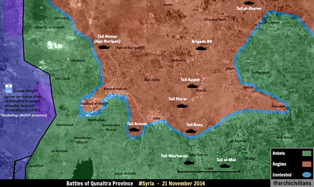
- Also Al Aboud it is Military Checkpoint.here And where data that this checkpoint was destroyed. Hanibal911 (talk) 17:27, 6 January 2015 (UTC)
Tall Mutawaq had a small base/CP on its top and is rebel held. Umm Rumman hill was captured from the rebels not long ago. It's kinda like Observatory 45 in Latakia, used to monitor the nearby plains. I don't know much about the rest. People might complain about the numerous hills in Daraa but thing is they are mostly military sites built in case of an Israeli Invasion. Some were built after the civil war began. SAA is not naive enough to leave hills, monitoring vast areas, empty. This saves the SAA manpower. Instead of deploying 300 troops around a rebel held village, deploy 100 on a hill monitoring the village. Basic Logic. So most hills in Daraa (rebel or regime held) are indeed military sites. Personally I've been to Daraa and I've seen some of those hills, they do monitor large large areas. I don't think we should remove them no matter who controls them. But again about the Khan Abou Shamat complex, nothing new has occurred no new sources were provided. We compromised and agreed before to remove it so now what has changed? Nothing has changed so why add it back?! Doesn't make any sense. ChrissCh94 (talk) 18:25, 6 January 2015 (UTC)
Al Shulah
ilooked at Wikimapia and I realised that it is literally nothing but there is a gas station next to it — Preceding unsigned comment added by 94.66.142.235 (talk) 14:02, 6 January 2015 (UTC)
Abu Shafiq (Morek)
This guy (pro-rebel, pro-Ukraine lol) tried to show the front line west from Morek. According to him, it's right there and it does look like that.
- Thoughts ? This is just an indication and not a source because i know the rules. DuckZz (talk) 20:35, 6 January 2015 (UTC)
As_Sa'an in Hama
Official NDF page reported rebel attacks on SAA/NDF positions near the town. Not the first of its kind. Should we add a green semi-circle to the north from the side of Rahjan? [15] ChrissCh94 (talk) 23:07, 6 January 2015 (UTC)
- It is just hit and run in this area. So dont need put semi-circle because we put this mark if we have several reports about clashes near city or village. Hanibal911 (talk) 07:47, 7 January 2015 (UTC)
- Yes but it is not the first time, if we have multiple hit and run raids shouldn't we put a semi-circle? ChrissCh94 (talk) 10:49, 7 January 2015 (UTC)