
File talk:Qing Dynasty 1820.png
I would like to propose a new version of this map, which would include areas directly ruled by the Qing in Yellow, and tributaries in Orange, to compare the sphere of influence and the actual regions controlled. Regards, -- 李博杰 | —Talk contribs 11:46, 20 February 2009 (UTC)
Korea
It would be better if Choson is added as a protectorate. —Preceding unsigned comment added by 82.134.154.25 (talk) 20:54, 9 March 2009 (UTC)
Chosŏn
Wasn't there a Chosŏn Province --82.134.154.25 (talk) 20:58, 11 August 2009 (UTC)
- No. See tributary state. -- 李博杰 | —Talk contribs email 07:25, 12 August 2009 (UTC)
Issues with map
The map is a modern fantasy, and have no historical basis. --Tbma (talk) 16:03, 13 July 2010 (UTC)
- Got a reason and source to back that talk up? You should give a detailed argument explaining why you think that is so, rather than just making such a statement without backing it up. -- 李博杰 | —Talk contribs email 13:02, 14 July 2010 (UTC)
- Thank you for the welcome, and of course I have reason and sources. Actually there are multiple reasons. Even outside of the borders of 1860s there was only 64 Chinese villages totaling 2800 people, and that was specifically noted. Otherwise than that there was no Chinese population included into Russian empire borders. That region was never solely owned by Qing Empire. a) Territories to the east of Khabarovsk were not populated not by russians not by Chineese and should be shown as neutral. In fact Chinese borders never not then not later crossed Amur river. b) Daur rulers decided to pay the tribute to the Qing, but that was never accepted by the Russian empire. c) Sakhalin was not known to the both empires, and both thought that it's a peninsula. Should be shown as unexplored. d) Protectorate status of Khalka should be shown because bogdo-genens has been accepted as vassals by the Emperor in 1691 and had the right to rule there. Tuva should be shown as a part of that protectorate. e) Lands between Amur in the north, Khabarovsk, Ussuri river, Bolshaya Ussurka river until the bottoms of Sikhote-Alin and there on the modern border - should be shown as contested by both empires and not owned by both (and largely unexplored). f) borders along Irtysh river should be shown as undelimited as it was since Treaty of Kyakhta in 1727. --Tbma (talk) 19:00, 14 July 2010 (UTC)
- Same thing with Kokand Khanate borders. They should be shown as undelimited, and should be shown as protectorate only. --Tbma (talk) 19:18, 14 July 2010 (UTC)
- User:Tbma is right on this one. Heilongjiang, Jilin, "Uliassutai", Inner Mongolia, Xinjiang, Qinghai, and Tibet are all shown as provinces on this map even though, in 1820, all of these areas were outside of the China proper (内地十八省) and were not administered as provinces and in many cases had only a weak tributary relationship with the Qing. In the case of some Turkic areas (as noted by User:Tbma) and most Tibetan areas (current Tibet, Qinghai, and western Sichuan), there was not even effective Qing control. Information supporting this can be found right here at Wikipedia (e.g., "In 1884, Qing China established Xinjiang as a province") with citations. I invite the author of the map or other users to address these issues so that the map or something similar can continue to be used in articles. — AjaxSmack 09:33, 10 September 2011 (UTC)
- Thank you AjaxSmack for turning my attention here. I have cited my sources in the image description and is thus not "original research." If you can provide a reference map for the borders as stated by Tbma I will look at it. The Treaty of Nerchinsk of 1689 delineates the borders between the Russians and Chinese as being the Stanovoy Mountains north of the Amur River, and would remain so until the Treaty of Aigun in 1858, with the Russians taking the land east of the Ussuri River in the Treaty of Peking in 1860. If your argument on the northeastern boundary is based on how many Chinese lived in these areas and not by international recognition, then by corollary, European colonial claims on Africa are fantasy maps as well and have no place in an encyclopedia.
- I will concede ambiguity in how much control the Qing had over Mongolia, Xinjiang, Tibet, and the South China Sea islands, particularly considering there was no international body at the time to establish what sovereignty is. Thus, I am looking to portray a map of the empire as it would have been portrayed internationally. To use an example, Tibet proclaimed independence in 1911, but the European and American governments denied Tibet recognition in favor of the ROC. Such a map would then show Tibet to be a part of the ROC. The Qing sphere of influence is much larger than the map shown here, so if someone can provide how these territories were recognized internationally (and whether they were different from how Korea and Vietnam were viewed), then I will look at it and adapt accordingly. Pryaltonian (talk) 11:14, 20 September 2011 (UTC)
- New version of the map is uploaded with colors differentiating between provinces, military governorates, and protectorates. Tributaries have been added in orange, as previously requested by Belinsquare. Qinghai is colored in as a province, as the Qing started governing Kham and Amdo as provinces within Sichuan and Qinghai, making it different from the governance of Bod (Tibet). I stand by the northeastern border drawn along the Stanovoys as accorded by the Treaty of Nerchinsk. Regarding Sakhalin, if both parties thought Sakhalin was a peninsula, then by that logic it is definitely part and parcel of the land south of the Stanovoys recognized to be under the Qing banner. Please refer to these contemporary, non-Chinese maps that recognize China's claim over Outer Manchuria and Sakhalin: http://web.archive.org/web/20070208043057/http://map.huhai.net/58-59.jpg and http://commons.wikimedia.org/wiki/File:John-Tallis-1851-Tibet-Mongolia-and-Manchuria-33621.jpg — Preceding unsigned comment added by Pryaltonian (talk • contribs) 15:32, 21 September 2011 (UTC)
- Interesting logic regarding Sakhalin. How someone can own something, if they don't even know how it looks like? Tbma (talk) 16:12, 22 September 2011 (UTC)
- Considering the source maps provided, is the issue that Sakhalin is being claimed as early as 1820 (but would be acceptable to be in a map from 1850), or that is it being claimed at all? Pryaltonian (talk) 16:30, 22 September 2011 (UTC)
- Would you be able to create an SVG vector image version as well, by any chance? -- 李博杰 | —Talk contribs email 22:50, 21 September 2011 (UTC)
- Unfortunately, I haven't learned how to make SVGs. I suppose I should get with the times eventually. Pryaltonian (talk) 15:39, 22 September 2011 (UTC)
- Interesting logic regarding Sakhalin. How someone can own something, if they don't even know how it looks like? Tbma (talk) 16:12, 22 September 2011 (UTC)
- New version of the map is uploaded with colors differentiating between provinces, military governorates, and protectorates. Tributaries have been added in orange, as previously requested by Belinsquare. Qinghai is colored in as a province, as the Qing started governing Kham and Amdo as provinces within Sichuan and Qinghai, making it different from the governance of Bod (Tibet). I stand by the northeastern border drawn along the Stanovoys as accorded by the Treaty of Nerchinsk. Regarding Sakhalin, if both parties thought Sakhalin was a peninsula, then by that logic it is definitely part and parcel of the land south of the Stanovoys recognized to be under the Qing banner. Please refer to these contemporary, non-Chinese maps that recognize China's claim over Outer Manchuria and Sakhalin: http://web.archive.org/web/20070208043057/http://map.huhai.net/58-59.jpg and http://commons.wikimedia.org/wiki/File:John-Tallis-1851-Tibet-Mongolia-and-Manchuria-33621.jpg — Preceding unsigned comment added by Pryaltonian (talk • contribs) 15:32, 21 September 2011 (UTC)
- User:Tbma is right on this one. Heilongjiang, Jilin, "Uliassutai", Inner Mongolia, Xinjiang, Qinghai, and Tibet are all shown as provinces on this map even though, in 1820, all of these areas were outside of the China proper (内地十八省) and were not administered as provinces and in many cases had only a weak tributary relationship with the Qing. In the case of some Turkic areas (as noted by User:Tbma) and most Tibetan areas (current Tibet, Qinghai, and western Sichuan), there was not even effective Qing control. Information supporting this can be found right here at Wikipedia (e.g., "In 1884, Qing China established Xinjiang as a province") with citations. I invite the author of the map or other users to address these issues so that the map or something similar can continue to be used in articles. — AjaxSmack 09:33, 10 September 2011 (UTC)
- Exactly as Tbma said, this map is modern fantasy, and have no historical basis for another reason: during the Qing dynasty there was no dotted-line as shown in the small box at the bottom left corner, The 11-dotted-line was not included in China map until 1946 or 1947 (see Li Jinming & Li Dexia, The Dotted Line on the Chinese Map of the South China Sea: A Note, The School of Southeast Asian Studies Xiamen University Xiamen, Fujian, China, 2002) — Preceding unsigned comment added by 114.77.204.44 (talk) 14:30, 21 April 2012 (UTC)
- Good points. There continue to be issues with this map that have not been addressed. Qinghai was not a province in 1820 (and as the map notes, Xining, its capital, was part of Gansu until 1928), Manchuria is not shown on the map. The whole Inner Mongolia/"Uliassutai"/Huijiang division is questionable. I actually like this map (or rather the idea of it) but, instead of starting with present-day boundaries and working backward, it would be better generated by working with contemporary sources as well as present-day sources that display a bit more heft than a Baidu Baike map. User:benlisquare has given some European sources below. To those I would add something like Historical Atlas of China for readers of Chinese or Herrmann's An Historical Atlas of China. — AjaxSmack 07:37, 29 October 2012 (UTC)
Old maps
Here are a few examples of old PD maps of Qing China:
-
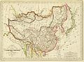
 1851 map of Tibet, Mongolia and Manchuria by John Tallis (interesting map of Chinese tartary inside the "Chinese Empire" (manchu empire at this time)
 -
 1844 map of China and Japan by John Nicaragua Dower
 -
 1833 French map of China and Japan
 -
 1832 French map of China and Japan
 -
 1836 French map of China and Japan

.jpg)
.jpg)
.jpg)
.jpg)
We can use these as a comparison. -- 李博杰 | —Talk contribs email 13:58, 23 September 2011 (UTC)
Here a few other old maps that can be used for territories whose level of incorporation into the Qing empire may vary depending on the period:
-
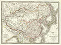
 1864 Mitchell Map of India, Tibet, China and Southeast Asia
 -
 1818 Pinkerton Map of India (Pakistan, Afghanistan, Tibet, Nepal, Sri Lanka)
 -
ohn-Tallis-1851-Tibet-Mongolia-and-Manchuria

_-_Geographicus_-_India-pinkerton-1818.jpg)
It is important though not to cherry pick maps that fits a specific point of view.--6-A04-W96-K38-S41-V38 (talk) 13:34, 29 October 2015 (UTC)
- Thanks for those maps 6-A04-W96-K38-S41-V38, the last one is the map of what was called by Europeans "chinese tartary" at this time (inside chinese empire that pass throught the map), sometime called dependencies. Yes, this is the Mandchu Empire (Qing dynasty), on the first you added, we can see that the kokonor (Khökh nuur meaning "blue lake" is the mongolian name, as used by Qoshot kanat that ruled the whole tibet was mainly in Kokonor) is called Qinghai (still the current chinese translation. some older maps call this kokonor. The map of Hindoustan has not interest for us, as that's a map India, not China, there are no administrative border outside of India, as between Tibet, Bootan, Assam, Meckley (Myanmar ?), Cabul and Kandahar for example.Popolon (talk) 22:59, 31 October 2015 (UTC)
-
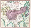 Chinese & independant Tartary (1806) (Sakhalin island was included at this time)

Nine-dash map
The Chinese nine-dash map didn't appear until the Republican era in 1947. Based on which historical basis does it appear in this map of 1820 China? DHN (talk) 07:14, 13 May 2014 (UTC)
- Yes, it's probably anachronistic, according to the article on nine-dash map. The Qing may have had recorded claims over island groups, however I don't think there were firmly defined territorial sea borders back in those times. --benlisquareT•C•E 09:28, 13 May 2014 (UTC)
Recent changes to the file on Commons
Whilst I have personally agreed within the discussion above that the 9-dash line should be removed, that doesn't mean that people should remove the inset completely. If a modification is to be made, someone should use an image editor to remove the 9 lines, however as of present there is no consensus to actually remove the inset box showing Qing claims to the South China Sea islands. What was argued above was that the 9-dash line didn't exist back then (it was created in 1947), however it does not refer to the actual Qing claims to the island. The Qing claimed those islands, they just didn't draw a 9-dashed maritime border like the ROC and PRC did. In addition, per Commons:Overwriting existing files a fork file should be created and any page should be directed to the newer fork image where necessary. --benlisquareT•C•E 04:55, 17 May 2014 (UTC)
Digital manipulation
Why is this map used at all? Is it based on a real map? Why not use that map instead of using this one that had been digitally manipulated with countless anachronisms? DHN (talk) 18:45, 1 June 2014 (UTC)
- Agree. This map, as well as other similar fantasy maps (e.g. 1, 2, 3) produced by wikipedians should be removed and replaced by real maps.--6-A04-W96-K38-S41-V38 (talk) 10:08, 29 October 2015 (UTC)

- Cartakes, everybody agrees that the maps should be based on reliable secondary sources. The problem in these four maps created by wp contributors is that they are not based on reliable secondary sources. On one side, I don't see how a 1910 map could be a reliable source for a 1820 reconstruction. On the other side, this digital modern fantasy does not correspond to the historical map you and Popolon have mentioned: to give just one example, Ladakh (including Aksai Chin) is part of the Indian Empire in the Cambridge map, but is part of Qing Empire in the present digital manipulation. This map should not be used in wikipedia articles.--6-A04-W96-K38-S41-V38 (talk) 08:26, 1 November 2015 (UTC)
- First of all, the map I originally referred to was actually a 1759 map by Cambridge, which remained the same until 1842 when Hong Kong island was ceded to the British. There should be no doubt that the map as a whole is indeed correct per Cambridge source. There might be relative minor issues need to be corrected (we can do it of course), such as in the case of Aksai Chin. Since the maps are generally identical, your claim that "they are not based on reliable secondary sources" is an exaggeration. Any other issues can you find besides Ladakh? Thanks! --Cartakes (talk) 16:04, 1 November 2015 (UTC)
- One difference should be enough to prove that the present map was not based on the Cambridge map isn't it? But yes, it is fully different from the map we are discussing here. Look at Mongolia, Manchuria, Taiwan, it appears completely differently on the Cambridge map. The Cambridge map does not mention province names as in this map, some island mentioned in this map do not appear on the Cambridge map, etc, etc. These maps have nothing in common. --6-A04-W96-K38-S41-V38 (talk) 16:32, 1 November 2015 (UTC)
- Nothing in common? This seems to be highly exaggerated. The most obvious common things we can understand from all these maps are that the Qing empire consisted of China (proper), Manchuria, (Inner and Outer) Mongolia, Xinjiang, and Qinghai and Tibet. Correct right? Let's talk about the Cambridge 1759 map (instead of 1910 map above) here, in my understanding there are only some differences in certain details such as the inclusion of Aksai Chin in its Tibetan part. Let's listen to what other editors would say about it and whether they are indeed "nothing in common". --Cartakes (talk) 16:50, 1 November 2015 (UTC)
- One difference should be enough to prove that the present map was not based on the Cambridge map isn't it? But yes, it is fully different from the map we are discussing here. Look at Mongolia, Manchuria, Taiwan, it appears completely differently on the Cambridge map. The Cambridge map does not mention province names as in this map, some island mentioned in this map do not appear on the Cambridge map, etc, etc. These maps have nothing in common. --6-A04-W96-K38-S41-V38 (talk) 16:32, 1 November 2015 (UTC)
- First of all, the map I originally referred to was actually a 1759 map by Cambridge, which remained the same until 1842 when Hong Kong island was ceded to the British. There should be no doubt that the map as a whole is indeed correct per Cambridge source. There might be relative minor issues need to be corrected (we can do it of course), such as in the case of Aksai Chin. Since the maps are generally identical, your claim that "they are not based on reliable secondary sources" is an exaggeration. Any other issues can you find besides Ladakh? Thanks! --Cartakes (talk) 16:04, 1 November 2015 (UTC)
- Cartakes, everybody agrees that the maps should be based on reliable secondary sources. The problem in these four maps created by wp contributors is that they are not based on reliable secondary sources. On one side, I don't see how a 1910 map could be a reliable source for a 1820 reconstruction. On the other side, this digital modern fantasy does not correspond to the historical map you and Popolon have mentioned: to give just one example, Ladakh (including Aksai Chin) is part of the Indian Empire in the Cambridge map, but is part of Qing Empire in the present digital manipulation. This map should not be used in wikipedia articles.--6-A04-W96-K38-S41-V38 (talk) 08:26, 1 November 2015 (UTC)
- DHN's problem was only with the Spratly and Paracel islands and he had no issue with the other parts of the map. There is no historian who draws Tibet as an independent entity from the Qing from 1720-1912. Maps drawn by westerners during the Qing dynasty itself show Tibet clearly as part of the Qing. [1].
- Your comment about western maps is off topic in this discussion, as this was not the point debated. But as you cherry-picked a map by Mitchell, let me give you the link to another map by the same Mitchell (1864), in which Tibet is not indicated as part of China.--6-A04-W96-K38-S41-V38 (talk) 23:03, 1 November 2015 (UTC)
- France had near zero effective control over massive swathes of Louisiana (New France) yet the entire Mississippi Drainage Basin is shown as French controlled on every single map of 18th century North America.Rajmaan (talk) 21:57, 1 November 2015 (UTC)
- DHN, myself and others in the previous section have pointed out countless anachronisms. If you refuse to see them, I can't help you.--6-A04-W96-K38-S41-V38 (talk) 23:03, 1 November 2015 (UTC)
- DHN's problem was only with the Spratly and Paracel islands and he had no issue with the other parts of the map. There is no historian who draws Tibet as an independent entity from the Qing from 1720-1912. Maps drawn by westerners during the Qing dynasty itself show Tibet clearly as part of the Qing. [1].
![[1]](https://commons.wikimedia.org/wiki/File:1853_Mitchell_Map_of_Russia_in_Asia_and_Tartary_-_Geographicus_-_RussiaAsia-mitchell-1850.jpg)