
Auli, India
Auli | |
|---|---|
Hill station | |
 View of Auli Hill station | |
 Auli Location in Uttarakhand  Auli Auli (India) | |
| Coordinates: 30°31′44″N 79°34′13″E / 30.52892°N 79.57026°E | |
| Country | |
| State | Uttarakhand |
| District | Chamoli |
| Elevation | 2,505 m (8,219 ft) |
| Languages | |
| Time zone | UTC+5:30 (IST) |
| Vehicle registration | UK |
| Website | uk |
Auli is in Chamoli district in the Himalayan mountains of Uttarakhand, India. Auli, also known as Auli Bugyal, in Garhwali, which means "meadow", is located at an elevation of 2,500 metres (8,200 ft) to 3,050 metres (10,010 ft) above sea level. Between June to October, the valley has one of highest number of flower species found anywhere in the world, with 520 species of high altitude plants, 498 of which are flowering plants with significant populations of endangered species.[1]
Tourism
Auli is a hiking and ski destination[2] and after the creation of the state of Uttarakhand, formerly part of Uttar Pradesh, Auli was marketed as a tourist destination. It is surrounded by coniferous and oak forests, with a panoramic view of the peaks of the Himalayas.[2] Since Auli is a skier's paradise, the period between late November and March is considered an ideal time to visit the hill station. The slopes are intended for both professional skiers and novices. The Garhwal Mandal Vikas Nigam Limited (GMVNL) a state govt agency which takes care of this resort, and Uttarakhand Tourism Department conduct winter sports competitions at Auli to encourage skiing in India.[3] It has a 4 kilometres (2.5 mi) cable car, a chairlift and a ski lift, along with a maintained trek route. There is a training facility of Indo-Tibetan Border Police. A small Hindu temple connected with the Hindu epic the Ramayana is also present.
Transportation
The nearest airport is Jolly Grant Airport in Dehradun, about 270 kilometres (170 mi) from Auli. The airport operates daily flights to Delhi, The nearest international airport is Indira Gandhi International Airport in Delhi, about 480 kilometres (300 mi) from Auli. The nearest railway stations are Rishikesh railway station (250 kilometres (160 mi)) and Dehradun railway station (290 kilometres (180 mi)). Nearby attractions include Vishnu Prayag, Gorson Bugyal, Kuari Pass, Joshimath, Badrinath, and Tapovan. Auli and Dehradun hosted the First South Asian Winter Games in 2011.
Accommodations in Auli
Auli has few hotels run by government and private both. GMVN is the government run hotel. Blue Poppy Resorts is one of the top rated hotels in Auli providing beautiful views from Auli. This resort is made up of alpine wood. There are other hotels also available in the area with basic facilities.

Gallery
-
 Rainbow in Auli
 -
 Himalayas near Auli
 -
Auli: elevation 3,000 m (9,800 ft)
-
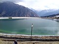 Lake in Auli
 -
 Cable car view, Auli
 -
 Chairlift in Auli


Climate
| Climate data for Auli | |||||||||||||
|---|---|---|---|---|---|---|---|---|---|---|---|---|---|
| Month | Jan | Feb | Mar | Apr | May | Jun | Jul | Aug | Sep | Oct | Nov | Dec | Year |
| Mean daily maximum °C (°F) | 7.1 (44.8) |
9 (48) |
13.1 (55.6) |
18.3 (64.9) |
21.6 (70.9) |
22.4 (72.3) |
20.5 (68.9) |
20 (68) |
18.9 (66.0) |
16.3 (61.3) |
12.3 (54.1) |
9.1 (48.4) |
15.7 (60.3) |
| Mean daily minimum °C (°F) | −1.6 (29.1) |
−0.4 (31.3) |
3.2 (37.8) |
6.7 (44.1) |
9.7 (49.5) |
12.1 (53.8) |
12.8 (55.0) |
12.7 (54.9) |
10.4 (50.7) |
6.1 (43.0) |
2.4 (36.3) |
−0.1 (31.8) |
6.2 (43.1) |
| Average precipitation mm (inches) | 119 (4.7) |
125 (4.9) |
139 (5.5) |
70 (2.8) |
56 (2.2) |
117 (4.6) |
333 (13.1) |
312 (12.3) |
186 (7.3) |
60 (2.4) |
28 (1.1) |
55 (2.2) |
1,600 (63.1) |
| Source: https://en.climate-data.org/location/275421/ | |||||||||||||
References
- ^ "Auli in the North Indian Himalayas". Auli.co.uk.
- ^ a b "Tourist places in Uttarakhand". Maps of India. India's No.1 map site. Retrieved 8 June 2013.
- ^ "Destination Auli". The Times of India. Retrieved 8 June 2013.