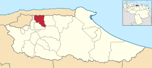
Sucre Municipality, Miranda
Sucre Municipality
Municipio Sucre | |
|---|---|
 Location in Miranda | |
| Coordinates: 10°28′19″N 66°45′39″W / 10.4719°N 66.7608°W | |
| Country | |
| State | Miranda |
| Founded | February 17, 1621 |
| Incorporated | 1989 |
| Municipal seat | Petare |
| Government | |
| • Mayor | José Vicente Rangel Ávalos (PSUV) |
| Area | |
| • Total | 199.0 km2 (76.8 sq mi) |
| Population (2016) | |
| • Total | 691,317 |
| • Density | 3,500/km2 (9,000/sq mi) |
| Time zone | UTC−04:00 (VET) |
| Area code(s) | 0212 |
| Website | Official website |
Sucre Municipality is one of the 21 municipalities (municipios) that makes up the Venezuelan state of Miranda and one of five the municipalities that make up the Metropolitan District of Caracas. According to a 2016 population estimate by the National Institute of Statistics of Venezuela, the municipality has a population of 691,317.[1] The parish of Petare is the municipal seat of the Sucre Municipality.[2]
Name
The municipality is one of several in Venezuela named "Sucre Municipality" in honour of Venezuelan independence hero Antonio José de Sucre.


Demographics
The Sucre Municipality, according to a 2016 population estimate by the National Institute of Statistics of Venezuela, has a population of 691,317 (up from 591,414 in 2000). This amounts to 2.2% of the state's population.[3] The municipality's population density (2016) is about 11,000 people per square mile (4,200/km²).[4]
Government
Mayors
| Period | Mayor | % of votes | Political party | Notes | |
|---|---|---|---|---|---|
| 1989-1993 | Enrique Mendoza | COPEI | First Mayor of municipality | ||
| 1993-1995 | Enrique Mendoza | COPEI | |||
| 1995-1998 | Raoul Bermúdez | COPEI | |||
| 1998-2000 | Raoul Bermúdez | COPEI | |||
| 2000-2004 | José Vicente Rangel Ávalos | 29,98 | MVR | 2000 Venezuelan general election | |
| 2004-2008 | José Vicente Rangel Ávalos | 50,91[5] | MVR/PSUV | Re elected | |
| 2008-2013 | Carlos Ocariz | 55,60[6] | Primero Justicia | ||
| 2013-2017 | Carlos Ocariz | 52,79 | Primero Justicia | Re elected | |
| 2017 | José Luis López | In charge of the office after Ocariz's resignation | |||
| 2017-2021 | José Vicente Rangel Ávalos | 59,85 | PSUV |
Education
This section needs expansion. You can help by adding to it. (July 2018) |
Colegio Japonés de Caracas (カラカス日本人学校), the sole Japanese international school in Venezuela, is in Sucre Municipality.[7]
References
- ^ http://www.ine.gob.ve/sintesisestadistica/estados/miranda/cuadros/Poblacion6.xls[permanent dead link]
- ^ "Archived copy". Archived from the original on 2007-12-21. Retrieved 2008-03-22.
{{cite web}}: CS1 maint: archived copy as title (link) - ^ http://www.ine.gob.ve/sintesisestadistica/estados/miranda/cuadros/Poblacion5.xls[permanent dead link]
- ^ http://www.ine.gob.ve/sintesisestadistica/estados/miranda/cuadros/Poblacion4.xls[permanent dead link]
- ^ CNE, 31-10-04 http://www.cne.gob.ve/regionales2004/
- ^ CNE, 23-11-08 http://www.cne.gob.ve/divulgacion_regionales_2008/index.php?e=13&m=09&p=00&c=00&t=00&ca=00&v=02
- ^ "学校案内." Colegio Japonés de Caracas. Retrieved on 7 July 2018. "所在地 Carretera Union Comunidad Juan Garcia El Otro Lado al Sur de Hatillo Distrito Sucre Edo.Miranda"


