
Clarkedale, Arkansas: Difference between revisions
Content deleted Content added
Gamapamani (talk | contribs) m fix lint error |
Patapsco913 (talk | contribs) →2020 census: tighten header |
||
| Line 95: | Line 95: | ||
===2020 census=== |
===2020 census=== |
||
{| class="wikitable" |
{| class="wikitable" style="text-align:center;" |
||
| ⚫ | |+'''Clarkedale city, Arkansas– Racial and ethnic composition'''<br /><small>{{nobold|''Note: the U.S. census treats Hispanic/Latino as an ethnic category. This table excludes Latinos from the racial categories and assigns them to a separate category. Hispanics/Latinos may be of any race.''}}</small> |
||
|+'''Clarkedale city, Arkansas – Demographic Profile'''<br> (''NH = Non-Hispanic'') |
|||
!Race / Ethnicity |
!Race / Ethnicity <small>(''NH = Non-Hispanic'')</small> |
||
!Pop 2010<ref name=2010CensusP2>{{Cite web|title=P2 |
!Pop 2010<ref name=2010CensusP2>{{Cite web|title=P2 Hispanic or Latino, and Not Hispanic or Latino by Race – 2010: DEC Redistricting Data (PL 94-171) – Clarkedale city, Arkansas|url=https://data.census.gov/cedsci/table?q=p2&g=1600000US0514050&tid=DECENNIALPL2010.P2|website=[[United States Census Bureau]]}}</ref> |
||
!Pop 2020<ref name=2020CensusP2>{{Cite web|title=P2 |
!Pop 2020<ref name=2020CensusP2>{{Cite web|title=P2 Hispanic or Latino, and Not Hispanic or Latino by Race – 2020: DEC Redistricting Data (PL 94-171) – Clarkedale city, Arkansas|url=https://data.census.gov/cedsci/table?q=p2&g=1600000US0514050&tid=DECENNIALPL2020.P2|website=[[United States Census Bureau]]}}</ref> |
||
!% 2010 |
!% 2010 |
||
!% 2020 |
!% 2020 |
||
| Line 139: | Line 139: | ||
|0.00% |
|0.00% |
||
|- |
|- |
||
|[[Multiracial Americans|Mixed Race |
|[[Multiracial Americans|Mixed Race or Multi-Racial]] (NH) |
||
|2 |
|2 |
||
|19 |
|19 |
||
| Line 157: | Line 157: | ||
|'''100.00%''' |
|'''100.00%''' |
||
|} |
|} |
||
| ⚫ | |||
<gallery class="center" widths="180px"> |
<gallery class="center" widths="180px"> |
||
File:Clarkedale AR 01 sign.jpg|Clarkedale Highway sign |
File:Clarkedale AR 01 sign.jpg|Clarkedale Highway sign |
||
</gallery> |
</gallery> |
||
==Education== |
==Education== |
||
Clarkedale is in the [[Marion School District (Arkansas)|Marion School District]].<ref>{{cite web|url=https://www2.census.gov/geo/maps/DC2020/PL20/st05_ar/schooldistrict_maps/c05035_crittenden/DC20SD_C05035.pdf|title=2020 CENSUS - SCHOOL DISTRICT REFERENCE MAP: Crittenden County, AR|publisher=[[U.S. Census Bureau]]|accessdate=September 22, 2022}}</ref> Its comprehensive high school is [[Marion High School (Arkansas)|Marion High School]]. |
Clarkedale is in the [[Marion School District (Arkansas)|Marion School District]].<ref>{{cite web|url=https://www2.census.gov/geo/maps/DC2020/PL20/st05_ar/schooldistrict_maps/c05035_crittenden/DC20SD_C05035.pdf|title=2020 CENSUS - SCHOOL DISTRICT REFERENCE MAP: Crittenden County, AR|publisher=[[U.S. Census Bureau]]|accessdate=September 22, 2022}}</ref> Its comprehensive high school is [[Marion High School (Arkansas)|Marion High School]]. |
||
Latest revision as of 16:27, 26 April 2024
Clarkedale, Arkansas | |
|---|---|
 | |
 Location of Clarkedale in Crittenden County, Arkansas. | |
 Clarkedale, Arkansas | |
| Coordinates: 35°18′23″N 90°14′10″W / 35.30639°N 90.23611°W | |
| Country | United States |
| State | Arkansas |
| County | Crittenden |
| Area | |
| • Total | 11.44 sq mi (29.62 km2) |
| • Land | 11.44 sq mi (29.62 km2) |
| • Water | 0.00 sq mi (0.00 km2) |
| Elevation | 223 ft (68 m) |
| Population (2020) | |
| • Total | 336 |
| • Density | 29.38/sq mi (11.34/km2) |
| Time zone | UTC-6 (Central (CST)) |
| • Summer (DST) | UTC-5 (CDT) |
| ZIP code | 72325 |
| Area code | 870 |
| FIPS code | 05-14050 |
| GNIS feature ID | 2404055[2] |
Clarkedale is a town[3] in Crittenden County, Arkansas, United States. Per the 2020 census, the population was 336.[4] Clarkedale incorporated on November 15, 2000.[5]
Demographics[edit]
| Census | Pop. | Note | %± |
|---|---|---|---|
| 2010 | 371 | — | |
| 2020 | 336 | −9.4% | |
| U.S. Decennial Census[6] 2010[7] 2020[8] | |||
2020 census[edit]
| Race / Ethnicity (NH = Non-Hispanic) | Pop 2010[7] | Pop 2020[8] | % 2010 | % 2020 |
|---|---|---|---|---|
| White alone (NH) | 303 | 276 | 81.67% | 82.14% |
| Black or African American alone (NH) | 50 | 29 | 13.48% | 8.63% |
| Native American or Alaska Native alone (NH) | 3 | 0 | 0.81% | 0.00% |
| Asian alone (NH) | 1 | 0 | 0.27% | 0.00% |
| Pacific Islander alone (NH) | 0 | 0 | 0.00% | 0.00% |
| Some Other Race alone (NH) | 0 | 0 | 0.00% | 0.00% |
| Mixed Race or Multi-Racial (NH) | 2 | 19 | 0.54% | 5.65% |
| Hispanic or Latino (any race) | 12 | 12 | 3.23% | 3.57% |
| Total | 371 | 336 | 100.00% | 100.00% |
-
 Clarkedale Highway sign

Education[edit]
Clarkedale is in the Marion School District.[9] Its comprehensive high school is Marion High School.
References[edit]
- ^ "2020 U.S. Gazetteer Files". United States Census Bureau. Retrieved October 29, 2021.
- ^ a b U.S. Geological Survey Geographic Names Information System: Clarkedale, Arkansas
- ^ Local.Arkansas.gov - Clarkedale, retrieved September 3, 2012
- ^ "Clarkedale city, Arkansas". United States Census Bureau. Retrieved April 15, 2022.
- ^ "Boundary Changes". Geographic Change Notes: Arkansas. Population Division, United States Census Bureau. January 1, 2010. Archived from the original on July 31, 2012. Retrieved June 13, 2011.
- ^ "Decennial Census of Population and Housing by Decades". US Census Bureau.
- ^ a b "P2 Hispanic or Latino, and Not Hispanic or Latino by Race – 2010: DEC Redistricting Data (PL 94-171) – Clarkedale city, Arkansas". United States Census Bureau.
- ^ a b "P2 Hispanic or Latino, and Not Hispanic or Latino by Race – 2020: DEC Redistricting Data (PL 94-171) – Clarkedale city, Arkansas". United States Census Bureau.
- ^ "2020 CENSUS - SCHOOL DISTRICT REFERENCE MAP: Crittenden County, AR" (PDF). U.S. Census Bureau. Retrieved September 22, 2022.
Municipalities and communities of Crittenden County, Arkansas, United States | ||
|---|---|---|
| Cities | 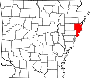 | |
| Towns | ||
| Unincorporated communities | ||
This article about a location in Crittenden County, Arkansas is a stub. You can help Wikipedia by expanding it. |