
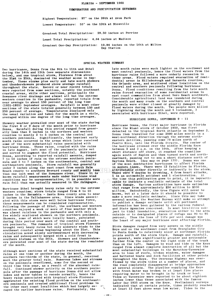
Hurricane Donna
| Category 5 major hurricane (SSHWS/NWS) | |
 Donna over the Florida Keys | |
| Formed | August 29, 1960 |
|---|---|
| Dissipated | September 14, 1960 |
| Highest winds | 1-minute sustained: 160 mph (260 km/h) |
| Lowest pressure | 930 mbar (hPa); 27.46 inHg |
| Fatalities | 164-364 total |
| Damage | $900 million (1960 USD) |
| Areas affected | Leeward Islands, Puerto Rico, Haiti, Dominican Republic, Cuba, Bahamas, East Coast of the United States, Southern Quebec, Atlantic Canada |
| Part of the 1960 Atlantic hurricane season | |
Hurricane Donna in the 1960 Atlantic hurricane season was a Cape Verde-type hurricane which moved across the Leeward Islands, Puerto Rico, Hispanola, Cuba, The Bahamas, and every state on the East Coast of the United States. Hurricane Donna holds the record for retaining major hurricane status (Category 3 or greater on the Saffir-Simpson Hurricane Scale) in the Atlantic Basin for the longest period of time. For nine days, September 2 to September 11, Donna consistently had maximum sustained winds of at least 115 mph (185 km/h). From the time it became a tropical depression to when it dissipated after becoming an extratropical storm, Donna roamed the Atlantic from August 29 to September 14, a total of 17 days. While crossing the Atlantic, Donna briefly achieved Category 5 strength.
Meteorological history

Tropical storm (39–73 mph, 63–118 km/h)
Category 1 (74–95 mph, 119–153 km/h)
Category 2 (96–110 mph, 154–177 km/h)
Category 3 (111–129 mph, 178–208 km/h)
Category 4 (130–156 mph, 209–251 km/h)
Category 5 (≥157 mph, ≥252 km/h)
Unknown
The precursor to this storm was a well-organized tropical disturbance which moved off the shore of Africa on August 28 and August 29. The crash of an airliner at Dakar on August 29 was attributed to this disturbance.[1] Before reaching the Cape Verde Islands, the system was well enough organized to be considered a tropical depression on August 29. By August 30, the system became Tropical Storm Donna. Moving westward, intensification continued, bringing the cyclone to hurricane strength on September 1. For nine days, September 2 to 11, Donna consistently had maximum sustained winds of at least 115 mph (185 km/h) as it moved west-northwest, briefly achieving Category 5 strength.[2] Donna passed through the northeasternmost Leeward Islands, subsequently missing Puerto Rico by 70 mi (110 km) to the north.[3] The hurricane then skirted the Cuba on September 9 before heading for the Florida Keys.[1]
The storm made its first Florida landfall in the community of Marathon, centered on Key Vaca in the middle Florida Keys. At the time, Donna was a Category 4 hurricane with estimated maximum sustained winds of 140 mph (230 km/h) and gusts of up to 180 mph (290 km/h), with a minimum central pressure of 930 mbar (27.46 inHg).[2] The storm crossed into the Gulf of Mexico and its course shifted northward. Donna paralleled the southwest coast of Florida until it made a second Florida landfall between Naples and Fort Myers, again as a Category 4 hurricane.[2] After crossing the Florida peninsula, it continued north and moved back out into the Atlantic Ocean near Daytona Beach. Donna made another landfall at Topsail Beach, North Carolina as a Category 2 hurricane. The storm continued up the Eastern Seaboard, and remained off the Mid-Atlantic Coast. Donna made a final landfall across eastern Long Island as strong Category 1, with winds near 95 mph (153 km/h).
Donna, unlike Hurricane Charley which followed a similar track in 2004,[4] was a slow-moving storm. Donna dumped 10 in (250 mm) to 12 in (300 mm) of rain in the southern half of Florida, along with about seven inches in the northern half.[5] The three weeks prior to Donna's landfall produced a 6 in (150 mm) to 7 in (180 mm) surplus in rain before the hurricane hit, exacerbating the problem. From the time it became a tropical depression to when it dissipated after becoming an extratropical storm, Donna roamed the Atlantic from August 29 to September 14, a total of 17 days.[2]
Preparations
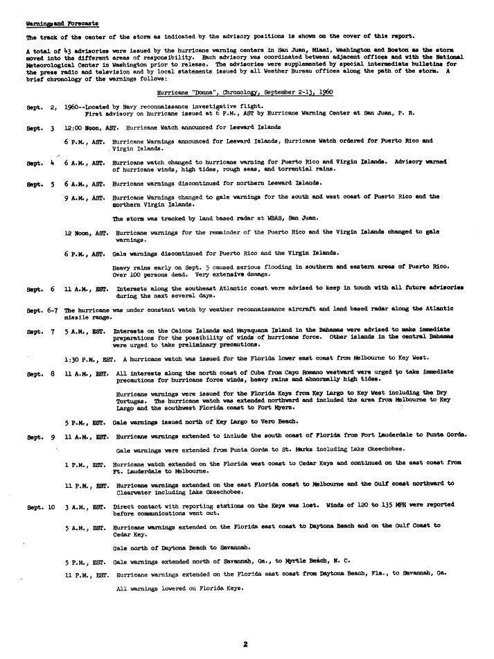
At noon on September 3, a hurricane watch was issued for the Leeward Islands, which at 6 p.m was upgraded to a warning. Also at 6 p.m., hurricane watches were raised for Puerto Rico and the Virgin Islands, which at 6 a.m. on September 4, were upgraded to warnings. By 6 a.m. on September 5, hurricane warnings were dropped for the Leeward Islands, and at 9 a.m., southwest Puerto Rico and the Virgin Island's hurricane warnings were downgraded to gale warnings. By noon, all remaining hurricane warnings for Puerto Rico were changed to gale warnings. At 7 a.m. on September 7, hurricane conditions were considered possible for the southeast Bahamas, with preliminary caution raised for the central Bahamas. At 1:30 p.m., a hurricane watch was issued for the Florida coast from Key West to Melbourne. Routes to Fort Lauderdale Beach were blocked off prior to the storm's arrival.[6] At 11 a.m. on September 8, hurricane conditions were considered possible for the Cuban coast west of Cayo Romano, and hurricane watches were upgraded to hurricane warnings from Key West to Key Largo, with hurricane watches raised on the west coast northward to Fort Myers. At 5 p.m., gale warnings were issued from Key Largo to Vero Beach.[7]

On September 9 at 11 a.m., hurricane warnings were in effect for southern Florida from Fort Lauderdale to Punta Gorda, while new gale warnings were raised from Punta Gorda to St. Marks and Lake Okeechobee. At 1 p.m., a hurricane watch was in effect from Punta Gorda to Cedar Key while a hurricane watch continued between Fort Lauderdale and Melbourne. By 11 p.m., hurricane warnings were extended northward to Melbourne and Clearwater, as well as Lake Okeechobee. At 5 a.m. on September 10, hurricane warnings were extended northward to Daytona Beach and Cedar Key. Gale warnings were issued from Daytona Beach to Savannah. At 5 p.m., gale warnings were extended northward to Myrtle Beach. At 11 p.m., hurricane warnings were lowered in the Florida Keys but extended northward from Daytona Beach to Savannah, Georgia.[7]
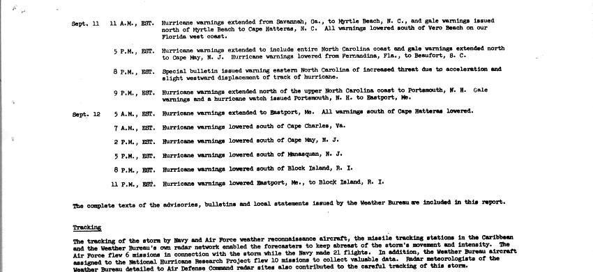
At 11 a.m. on September 11, all warnings were lowered south of Vero Beach and along the Florida west coast, while hurricane warnings were extended northward from Savannah to Myrtle Beach. At 5 p.m., hurricane warnings were lowered south of Fernandina Beach, while they were extended northward to include the entire North Carolina coast. Gale warnings were issued northward to Cape May. At 9 p.m., hurricane warnings were extended northward to Portsmouth, New Hampshire, while gale warnings and a hurricane watch were issued northward to Eastport, Maine. Ships at dock in Newport, Rhode Island were towed out into the bay to weather the storm.[8] On September 12 at 5 a.m., hurricane warnings were extended northward to Eastport, and dropped south of Cape Hatteras. At 7 a.m., hurricane warnings were lowered south of Cape Charles. At 2 p.m., hurricane warnings were dropped south of Cape May. At 5 p.m., hurricane warnings were discontinued south of Manasquan, New Jersey. At 8 p.m., hurricane warnings expired south of Block Island. By 11 p.m. on September 12, all hurricane warnings had been lowered.[9]
Impact

Hurricane Donna was a very destructive hurricane that caused extensive damage from the Lesser Antilles to New England. At least 364 people were killed by the hurricane and over $900 million in damage were done (1960 USD).[10]
Leeward Islands
A weather station in Sint Maarten reported a sustained wind of 120 mph (195 km/h) and a 952 pressure reading in the main airport. Hurricane Donna caused very extensive damage on the island, killed 7 and left at least a quarter of the island's population homeless. On the island of Anguilla similar conditions could have been felt due to its close proximity to the island of St. Maarten which is just about 8 mi (13 km) in between. During the passing of hurricane Donna Anguilla recorded five deaths, including a woman who died when the roof of her house collapsed. St. Thomas reported a 41 mph (66 km/h) gust as the center of Donna passed 35 mi (56 km) north of the island. In Puerto Rico, Donna produced storm tides between 4 to 6 ft (1.2 to 1.8 m).[1]
Donna killed seven people and caused minimal damage when it passed though the Virgin Islands. A large portion of eastern Puerto Rico received over 10 inches (250 mm) of rainfall.[5] Although the center of the storm was 85 mi (137 km) offshore, the outer rain bands brought heavy rains that caused serious flash flooding which killed 107 people (85 of them in Humacao).[1]

Bahamas
The Turks and Caicos escaped the brunt of the hurricane, receiving only 50 to 60 mph (80 to 97 km/h) winds and 12 in (300 mm) of rain which fell in a twelve hour period. In the Bahamas, the anemometer at Ragged Island blew away after registering a 150 mph (240 km/h) wind gust. At Mayaguana, hurricane force winds raged for 13 hours. Many of the residents sought shelter at a nearby missile tracking station. Several small island communities in the central Bahamas were leveled. North Caicos reported 20 inches (510 mm) of rainfall in 24 hours.[11] Despite the impact, there were no deaths and damage estimates are not available.[1]
Florida
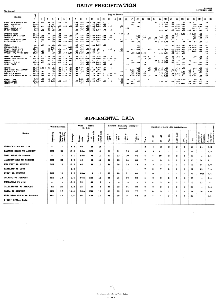
Donna was the first hurricane to affect Miami since October 1950.[3] The highest sustained winds were 92 miles per hour (148 km/h) at Fort Myers and 65 miles per hour (105 km/h) at Key West.[12] Florida suffered significant losses from Donna, more than any other state. Damage in the Keys at the original point of landfall was most severe, where Donna's winds and storm surge destroyed many buildings and vessels. A storm surge of 13 ft (4.0 m) was reported at Marathon.[5]
Portions of southern and western Florida received over 10 in (250 mm) of rainfall from the hurricane.[5] Large tracts of mangrove forest were lost in the western portion of Everglades National Park, while at least 35 % of the white heron population in the park were killed.[13] A total of 35% of the state's grapefruit crop was lost, 10% of the orange and tangerine crop was lost, and the avocado crop was almost completely destroyed. Donna was the most damaging tropical cyclone to impact Florida up to that time. The day after the storm hit, President Dwight D. Eisenhower declared a disaster area from the Keys up to Central Florida.[14]
Elsewhere in the East
| Costliest U.S. Atlantic hurricanes, 1900–2017 Direct economic losses, normalized to societal conditions in 2018[15] | |||
|---|---|---|---|
| Rank | Hurricane | Season | Cost |
| 1 | 4 "Miami" | 1926 | $235.9 billion |
| 2 | 4 "Galveston" | 1900 | $138.6 billion |
| 3 | 3 Katrina | 2005 | $116.9 billion |
| 4 | 4 "Galveston" | 1915 | $109.8 billion |
| 5 | 5 Andrew | 1992 | $106.0 billion |
| 6 | ET Sandy | 2012 | $73.5 billion |
| 7 | 3 "Cuba–Florida" | 1944 | $73.5 billion |
| 8 | 4 Harvey | 2017 | $62.2 billion |
| 9 | 3 "New England" | 1938 | $57.8 billion |
| 10 | 4 "Okeechobee" | 1928 | $54.4 billion |
| Main article: List of costliest Atlantic hurricanes | |||
Although weaker, Donna caused considerable and widespread damage from the Carolinas through New York. Beaufort County, South Carolina, for example, saw many trees uprooted, power lines downed, homes unroofed, piers destroyed, and significant damage to corn and soybean crops. Wind gusts of 105 miles per hour (169 km/h) were reported from the Eastern Shore of Chesapeake Bay. Maximum sustained winds of 105 mph (169 km/h) with gusts of 115 mph (185 km/h) were reported from Long Island and Rhode Island.[16] Storm surge values reached 11 ft (3.4 m) in New York Harbor, which wrecked area piers.[17] A resort area in Cliffwood Beach, New Jersey saw its boardwalk and tourist attractions destroyed by the hurricane, and the area has never recovered.
Blue Hill Observatory in Massachusetts reported gusts to over 145 mph (233 km/h).[1] The strong southwest winds associated with Donna at Chatham, in combination with very little rainfall, led to a significant deposit of salt spray which whitewashed southwest-facing windows. Many trees and shrubs saw their leaves brown due to the salt.[18] A swath of 5 to 10 in (130 to 250 mm) of rain fell from North Carolina northeast into Maine.[5] Fifty people were reported dead in the United States, with damages totaling to $3.35 billion (2006 USD).[19] Donna crossed directly over Texas Tower 4, causing severe damage to the structure and leading to its eventual loss with all hands in January 1961.[20]
Donna was the only hurricane to affect every state along the East Coast with hurricane-force winds.[21]
Depictions in popular culture
Nobel Prize-winner John Steinbeck wrote about Hurricane Donna in his 1962 non-fiction memoir Travels with Charley: In Search of America. Steinbeck had had a truck fitted with a custom camper-shell for a journey he intended to take across the United States, accompanied by his poodle Charlie. He planned on leaving after Labor Day from his home in Sag Harbor, Long Island, New York. Steinbeck delayed his trip slightly due to Donna, which made a direct hit on Long Island. Steinbeck wrote of saving his boat during the middle of the hurricane, during which he jumped into the water and was blown to shore clinging to a fallen branch driven by the high winds. It was an exploit which foreshadowed his fearless, or even reckless, state of mind to dive into the unknown.
The winds of Donna can be seen in the feature film Blast of Silence (1961); a fist fight scene on Long Island had been previously scheduled, and the filmmakers decided to go ahead and shoot the exterior scene despite the hurricane.[22]
Aftermath, records and retirement

In Marathon, a large reconstruction program rehabilitated the key by Christmas.[23] Coral reefs were damaged in the Key Largo National Marine Sanctuary by the hurricane.[24] Donna caused a significant negative impact on aquatic life in north Florida Bay. Marine life was either stranded by retreating salt water which had been driven inland or killed by muddied waters in its wake. Oxygen depletion due to animals perishing in the hurricane caused additional mortality. Although salinity levels returned to normal within six weeks, dissolved oxygen concentrations remained quite low for a longer time frame. Marine life was scarce for several months in areas of greatest oxygen depletion. Sports fishing in the area took a few months to recover. Juvenile pink shrimp moved from their estuarine nursery grounds into deeper water about 60 mi (97 km) offshore, where they were subsequently captured by fishermen.[25] A Caspian Tern was swept up the North American coast well to the north of its traditional breeding grounds, to Nova Scotia, which was witnessed four hours after the storm went by Digby Neck.[26]
Because of its devastating impacts and the high mortality associated with the hurricane, the name Donna was retired, and will never again be used for an Atlantic hurricane; the name was replaced by Dora in 1964.[27]
Donna was one of the five rare Cape Verde storms to hit the U.S mainland after being named east of 35°W. Other storms were Hurricane Hugo in 1989, Hurricane Georges in 1998, Hurricane Isabel in 2003, and Hurricane Ivan in 2004.[2]
See also
- List of retired Atlantic hurricane names
- List of Florida hurricanes (1950–1974)
- List of wettest tropical cyclones in Massachusetts
- List of New England hurricanes
- List of North Carolina hurricanes
- List of New York hurricanes
- List of Delaware hurricanes
References
- ^ a b c d e f Gordon E. Dunn (1960). The 1960 Atlantic Hurricane Season., Weather Bureau Office, Retrieved on 2008-10-10.
- ^ a b c d e Atlantic Hurricane Database. National Hurricane Center (2007). Retrieved on 2008-10-10. Cite error: The named reference "HURDAT" was defined multiple times with different content (see the help page).
- ^ a b Climatological Data: Florida - September 1960, pp. 2. National Climatic Data Center (1960). Retrieved on 2008-10-10. Cite error: The named reference "NCDC2" was defined multiple times with different content (see the help page).
- ^ Richard J. Pasch, Daniel P. Brown, and Eric S. Blake (2004). Hurricane Charley Tropical Cyclone Report. National Hurricane Center. Retrieved on 2006-05-24.
- ^ a b c d e David M. Roth (2008). Hurricane Donna - September 3-12, 1960. National Weather Service. Retrieved on 2008-10-10. Cite error: The named reference "DRrain" was defined multiple times with different content (see the help page).
- ^ Alan MacLeese (1960). Hurricane Donna: 80-mile winds rake city. Sun Sentinel. Retrieved on 2008-10-10.
- ^ a b Hurricane "Donna" Chronology, September 2-13, 1960. United States Weather Bureau Office of Climatology (1960). Retrieved on 2008-10-10.
- ^ Ron Fritz (2008). USS Fred T. Berry DD/DDE 858 Ship's History Addenda: Hurricane Donna. Ron Fritz. Retrieved on 2008-10-10.
- ^ Hurricane "Donna" Chronology page 2, September 2-13, 1960. United States Weather Bureau Office of Climatology (1960). Retrieved on 2008-10-10.
- ^ Edward N. Rappaport and Jose Fernandez-Partagas. The Deadliest Atlantic Tropical Cyclones, 1492-1996. National Hurricane Center. Retrieved on 2008-10-13.
- ^ 2007 Hurricane Guide: Are You Prepared? Turks & Caicos Islands Red Cross (2007). Retrieved on 2008-10-10.
- ^ Climatological Data: Florida - September 1960, pp. 9. National Climatic Data Center (1960). Retrieved on 2008-10-10.
- ^ Jason P. Dunion, Christopher W. Landsea, Samuel H. Houston,* and Mark D. Powell (2003). A Reanalysis of the Surface Winds for Hurricane Donna of 1960. National Oceanic and Atmospheric Administration. Retrieved on 2008-10-13.
- ^ Presidential Disaster Declarations for Florida in 1960 By Type. Public Entity Risk Institute (2008). Retrieved on 2008-10-10.
- ^ Weinkle, Jessica; et al. (2018). "Normalized hurricane damage in the continental United States 1900–2017". Nature Sustainability. 1: 808–813. doi:10.1038/s41893-018-0165-2.
- ^ "Losses Heavy As Donna Rips Through County" (PDF). Beaufort County Community College. 1960. Retrieved 2011-02-21.
- ^ Ben Hogwood (2008-08-28). "Flirting With Disaster; City Enters Storm Season". Queens Chronicle. Retrieved 2011-02-21.
{{cite web}}: Italic or bold markup not allowed in:|publisher=(help) - ^ Arnold Arboretum (1961-09-08). "Hurricane "Donna" and its After Effects to a Chatham, Massachusetts, Garden" (PDF). Harvard University. Retrieved 2011-02-21.
- ^ Eric S. Blake, Edward N. Rappaport, Christopher W. Landsea (2007-04-15). "The Deadliest, Costliest, and Most Intense United States Tropical Cyclones from 1851 to 2006 (And Other Frequently Requested Hurricane Facts)" (PDF). National Hurricane Center. Retrieved 2011-02-21.
{{cite web}}: CS1 maint: multiple names: authors list (link) - ^ Thomas Ray. "A history of Texas Towers in air defense 1952-1964". The Texas Tower Association. Retrieved 2011-02-21.
- ^ "Hurricane History". National Hurricane Center. 2008. Retrieved 2011-02-21.
- ^ "Trivia for Blast of Silence (1961)". Turner Classic Movies. Retrieved 2011-02-21.
- ^ Larry Solloway (1960-12-25). "Face-Lifting Erases Scar Donna Left in Keys". New York Times. Retrieved 2011-02-21.
{{cite web}}: Italic or bold markup not allowed in:|publisher=(help) - ^ "The Effects of African Dust on Coral Reefs and Human Health". United States Geological Survey. 2010-06-14. Retrieved 2011-02-21.
- ^ Tabb, Durbin C. and Jones, Albert C. (1962). Effect of Hurricane Donna on the Aquatic Fauna of North Florida Bay. Transactions of the American Fisheries Society. Vol. 91, Issue 4. pp. 375–378.
- ^ "Caspian Tern". Nova Scotia Museum of Natural History. 1998-02-20. Retrieved 2011-02-21.
- ^ "Retired Hurricane Names Since 1954". National Hurricane Center. 2009-04-22. Retrieved 2011-02-21.
External links
- Images from the Naples Daily News of Donna
- Historic Images of Florida Hurricanes (Florida State Archives)
- NOAA Hurricane Research Division Donna page
- HPC Rainfall Page on Donna
| 1950s | |
|---|---|
| 1960s | |
| 1970s | |
| 1980s | |
| 1990s | |
| 2000s | |
| 2010s | |
| 2020s | |
| 1920s |
|
|---|---|
| 1930s |
|
| 1940s |
|
| 1950s | |
| 1960s | |
| 1970s | |
| 1980s | |
| 1990s | |
| 2000s | |
| 2010s | |
| 2020s | |
Tropical cyclones of the 1960 Atlantic hurricane season | ||
|---|---|---|
 | ||
- 1960 Atlantic hurricane season
- Category 5 Atlantic hurricanes
- Cape Verde-type hurricanes
- Retired Atlantic hurricanes
- Hurricanes in the Caribbean
- Hurricanes in the Leeward Islands
- Hurricanes in Desirade
- Hurricanes in Guadeloupe
- Hurricanes in Antigua and Barbuda
- Hurricanes in Montserrat
- Hurricanes in Saint Kitts and Nevis
- Hurricanes in Saint Barthélemy
- Hurricanes in Sint Eustatius
- Hurricanes in Saint Martin
- Hurricanes in Sint Maarten
- Hurricanes in Saba
- Hurricanes in Anguilla
- Hurricanes in the British Virgin Islands
- Hurricanes in the United States Virgin Islands
- Hurricanes in Puerto Rico
- Hurricanes in the Turks and Caicos Islands
- Hurricanes in the Bahamas
- Hurricanes in Cuba
- Hurricanes in Florida
- Hurricanes in Georgia (U.S. state)
- Hurricanes in South Carolina
- Hurricanes in North Carolina
- Hurricanes in Virginia
- Hurricanes in New Jersey
- Hurricanes in New York
- Hurricanes in New England
- 1960 in the Caribbean
- 1960 in the United States
- 1960 meteorology
- 1960 natural disasters
- Natural disasters in the Leeward Islands
- Natural disasters in Antigua and Barbuda
- Natural disasters in Sint Maarten