
Lanai
Template:Infobox Hawaiian island
Lānaʻi or Lanai (/[invalid input: 'icon']ləˈnaɪ/; Hawaiian: [laːˈnɐʔi] or [naːˈnɐʔi]) is the sixth-largest of the Hawaiian Islands. It is also known as the Pineapple Island because of its past as an island-wide pineapple plantation. The only town is Lānaʻi City, a small settlement. The island is somewhat comma-shaped, with a width of 18 miles (29 km) in the longest direction. The land area is 140.5 square miles (364 km2), making it the 42nd largest island in the United States.[1] It is separated from the island of Molokaʻi by the Kalohi Channel to the north, and from Maui by the ʻAuʻau Channel to the east. The United States Census Bureau defines Lānaʻi as Census Tract 316 of Maui County. Its total population shrank from 3,193 as of the 2000 census[2] to 3,102 as of 2010.[3] Many of the island's landmarks and sites are reached by dirt roads that require a four-wheel drive vehicle.
There is one school, Lanai High and Elementary School, serving the entire island from Kindergarten through Senior in high school. There are no traffic lights on the entire island.
History
Lānaʻi was under the control of nearby Maui throughout before recorded history. Its first inhabitants may have arrived as late as the 15th century.
The name Lānaʻi is of uncertain origin, but the island has historically been called Lānaʻi o Kauluāʻau, which literally means "Lānaʻi of Kauluāʻau." This epiphet refers to the legend of a Mauian prince, who, for some of his wild pranks at his father's court in Lāhainā, was banished to Lānaʻi, which was said to have been terribly haunted by Akua-ino, ghosts and goblins. Kauluāʻau, however, by his prowess and skill, exorcised the spirits, brought about peace and order on the island, and was in consequence restored to the favour of his father.
The first people to migrate here, most likely from Maui and Molokaʻi, probably established fishing villages along the coast initially but later branched out into the interior where they raised taro in the fertile volcanic soil. During most of those times, the Moʻi of Maui held dominion over Lānaʻi, but generally left the people of Lānaʻi to their own devices. Life on Lānaʻi remained relatively calm until King Kamehameha I or Kalaniʻōpuʻu-a-Kaiamamao took control, slaughtering people on every part of the island. So many were killed that when Captain George Vancouver sailed past the island in 1792, he didn't bother to land because of Lānaʻi's apparent lack of villages and population. It is mentioned that Lānaʻi was Kamehameha's favorite fishing spot across Hawaii's main eight islands.
Lānai was first seen by Europeans on February 25, 1779, when Captain Charles Clerke sighted the island from aboard James Cook's HMS Resolution. Clerke had taken command of the ship after Cook was killed at Kealakekua Bay on February 14 and was leaving the islands for the North Pacific.[citation needed]
By the 1870s, Walter M. Gibson had acquired most of the land on the island for ranching. Prior to this he had used it as a Mormon colony. In 1899, his daughter and son-in-law formed Maunalei Sugar Company, headquartered in Keomuku on the windward coast downstream from Maunalei Valley. However the company lasted only until 1901.[4] Nevertheless, many Native Hawaiians continued to live along the less arid windward coast, supporting themselves by ranching and fishing until pineapples displaced ranching.[5]
In 1922, James Dole, the president of Hawaiian Pineapple Company (later renamed Dole Food Company), bought the entire island of Lānaʻi and developed a large portion of it into the world's largest pineapple plantation.
With statehood, Lānaʻi became part of the County of Maui.
In 1985, Lānaʻi passed into the control of David H. Murdock, as a result of his purchase of Castle & Cooke and has now again (2011) been put on the market.
Legends
According to the Hawaiian legends, man-eating spirits occupied the island before that time. For generations, Maui chiefs believed in these man-eating spirits. Differing legends say that either the prophet Lanikāula drove the spirits from the island or the unruly Maui prince Kauluāʻau accomplished that heroic feat. The more popular myth is that the mischievous Kauluāʻau pulled up every ʻulu (Artocarpus altilis) tree he could find on Maui. Finally his father, Kakaʻalaneo had to banish him to Lānaʻi, expecting him not to survive in that hostile place. However Kauluāʻau outwitted the spirits and drove them from the island. The chief looked across the channel from Maui and saw that his son's fire continued to burn nightly on the shore, and he sent a canoe to Lānaʻi to bring the prince, redeemed by his courage and his cleverness, back home to Maui. As a reward, Kakaʻalaneo gave Kauluāʻau control of the island and encouraged emigration from other islands.[6] Kauluāʻau had, in the meantime, pulled up all the ʻulu trees on Lānaʻi, accounting for the historic lack of ʻulu on that island.
Geography
Traditionally, Lānaʻi was subdivided into 13 Ahupuaʻa, grouped into two districts (mokuoloko): kona (Leeward) and koolau (Windward). The ahupuaʻa are listed below, in clockwise sequence, and with original area figures in acres, starting in the northwest of the island.[7]

| Nr. | Ahupuaʻa | Area acres |
Area km² |
popu- lation[8] |
|---|---|---|---|---|
| 1 | Kaa | 19468 | 78.78 | 207 |
| 2 | Paomai | 9078 | 36.74 | 147 |
| 3 | Mahana | 7973 | 32.27 | 1 |
| 4 | Maunalei | 3794 | 15.35 | 0 |
| 5 | Kalulu | 6078 | 24.60 | 1 |
| 6 | Kaunolu | 7860 | 31.81 | 3 |
| 7 | Palawai | 5897 | 23.86 | 1 |
| 8 | Pawili | 1930 | 7.81 | 0 |
| 9 | Kaohai | 9677 | 39.16 | 1 |
| 10 | Kamao | 2751 | 11.13 | 2 |
| 11 | Kealia Aupuni | 5897 | 23.86 | 2 |
| 12 | Kealia Kapu | 1829 | 7.40 | 1 |
| 13 | Kamoku | 8291 | 33.55 | 2804 |
| Lānaʻi | 90523 | 366.33 | 3170 |
Kamoku hosts the largest share of population, because the bigger part of Lānaʻi City falls into it. Parts of Lanaʻi City stretch to Kaa and Paomai. As of 2010, the remaining ahupuaʻa were virtually uninhabited. According to the census of 2000, Lanaʻi City accounts for 99 percent of the island population (3164 of 3193). As a census designated place, Lanaʻi City is defined solely for statistical purposes, and not by administrative boundaries.
Tourism
Tourism on Lānaʻi began to be prominent in more recent history as the pineapple and sugarcane industries were phased out in the islands.
As of 2011, the two resort hotels on Lānaʻi were managed by Four Seasons Hotels; the Four Seasons Resort Lanai and the Lodge at Kōʻele. The Hotel Lānaʻi in Lānaʻi City was built in 1923 by James Dole of the Hawaiian Pineapple Company as a lodge to house the executives overseeing the island’s pineapple production. It was the island’s only hotel until 1990.
Lānaʻi is also home to two golf courses, one at each Four Seasons resort. "The Challenge at Manele" borders the ocean and was designed by Jack Nicklaus. "The Experience at Koele" is located in the mountains of Lānaʻi and was designed by Greg Norman. Bill Gates was married on the 12th hole tee-box at The Challenge at Manele.
In Lānaʻi City, there are no traffic lights, no shopping malls, and public transportation is supplied by a hotel contractor. For a one-time fee, hotel guests enjoy unlimited rides on small and large buses that go between the hotels and the ferry landing on Manele Bay. Bicycles and off-road vehicles are for rent. Most attractions outside of the hotels and town can be visited only via dirt roads that require an off-road vehicle.
Gallery
-
 View of a former Lānaʻi pineapple field, now a field of grass
 -
 View of some local houses in Lānaʻi City
 -
 View of Garden of the Gods
 -
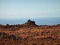 Garden of the Gods (another view)
 -
 Mountains on Lānaʻi
 -
 Shipwreck Beach sign
 -
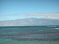 View of East Molokaʻi from Shipwreck Beach, Lānaʻi.
 -
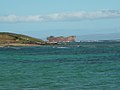 View of the shipwreck at Shipwreck Beach
 -
 The Stables at Kōʻele
 -
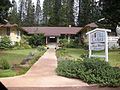 Hotel Lānaʻi
 -
 Hole 17 at the Experience at Kōʻele golf course
 -
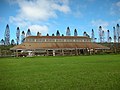
 The Lodge at Kōʻele


.jpg)

See also
References
- ^ "Table 5.08 - Land Area of Islands: 2000" (PDF). 2004 State of Hawaii Data Book. State of Hawaii. 2004. Retrieved 2007-07-23.
{{cite web}}: External link in|work= - ^ Census Tract 316, Maui County United States Census Bureau
- ^ "Lanai city" (PDF). State of Hawaii. Retrieved November 17, 2011.
- ^ "Maunalei, Keomoku and the Kahalepalaoa Vicinity". Lānaʻi Culture & Heritage Center. Retrieved 2010-12-10.
- ^ Kaye, Robin (1982). Lanai Folks. Honolulu: University of Hawaii Press. pp. 16–17. ISBN 0-8248-0623-9.
- ^ Let's Go Hawaii: On a Budget by Sara Joy Culver (Let's Go Inc.), p. 350
- ^ The Mahele Aina on Lanai,About Hawaiian Land Management and Land Tenure
- ^ city-data.com
External links
- "Chapter 6: Lānaʻi" (PDF). Hawaii’s Comprehensive Wildlife Conservation Strategy. State of Hawaiʻi. 2005-10-01.
State of Hawaii | |
|---|---|
Honolulu (capital) | |
| Topics | |
| Society | |
| Main islands | |
| Northwestern Islands | |
| Notable communities | |
| Counties | |
| Pre-statehood history | |
