Mont Ngaoui

Coordinates: 6°45′05″N 14°57′35″E / 6.75139°N 14.95972°E / 6.75139; 14.95972
From Wikipedia, the free encyclopedia

This is the current revision of this page, as edited by Ken Gallager (talk | contribs) at 13:42, 29 January 2019 (cat sort). The present address (URL) is a permanent link to this version.

(diff) ← Previous revision | Latest revision (diff) | Newer revision → (diff)
Mont Ngaoui
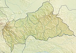
Mont Ngaoui is located in Central African Republic
Mont Ngaoui
Mont Ngaoui
Location in the Central African Republic (on the border with Cameroon)
Highest point
Elevation1,410 m (4,630 ft)
ListingCountry high point
Coordinates6°45′05″N 14°57′35″E / 6.75139°N 14.95972°E / 6.75139; 14.95972
Geography
LocationCentral African Republic / Cameroon

Mont Ngaoui is the highest mountain in the Central African Republic. It is located on the border with Cameroon and has a summit elevation of 1,410 metres (4,626 ft).

External links[edit]