Porrogszentpál
Porrogszentpál
Porog - Sveti Pavel (in Slovene) Supal (in Croatian) | |
|---|---|
Village | |
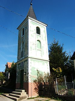
 The bell tower in Porrogszentpál | |
| Coordinates: 46°17′10″N 17°00′54″E / 46.28616°N 17.01493°E | |
| Country | |
| Region | Southern Transdanubia |
| County | Somogy |
| District | Csurgó |
| RC Diocese | Kaposvár |
| Area | |
| • Total | 3.54 km2 (1.37 sq mi) |
| Population (2017) | |
| • Total | 86[1] |
| Demonym(s) | szentpáli, porrogszentpáli |
| Time zone | UTC+1 (CET) |
| • Summer (DST) | UTC+2 (CEST) |
| Postal code | 8858 |
| Area code | (+36) 82 |
| Patron Saint | Paul the Apostle |
| NUTS 3 code | HU232 |
| MP | László Szászfalvi (KDNP) |
Porrogszentpál (Slovene: Porog - Sveti Pavel, Croatian: Supal) is a village in Somogy County, Hungary, where Somogy Slovenes live.
External links[edit]
References[edit]


