Side by side comparison| {{Infobox Switzerland municipality}} | {{Infobox Switzerland municipality/sandbox}} |
|---|
Lausanne |
|---|
|
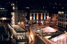 Europe square by night |
 Coat of arms | Show map of Canton of Vaud | | Coordinates: 46°31′N 6°38′E / 46.517°N 6.633°E / 46.517; 6.633 | | Country | Switzerland |
|---|
| Canton | Vaud |
|---|
| District | Lausanne |
|---|
|
| • Mayor | Syndic (list)
Daniel Brélaz GPS
(as of 2007) |
|---|
|
| • Total | 41.37 km2 (15.97 sq mi) |
|---|
| Elevation (375 m - 900 m) | 495 m (1,624 ft) |
|---|
|
| • Total | 128,302 |
|---|
| • Density | 3,100/km2 (8,000/sq mi) |
|---|
| Demonym | Les Lausannois |
|---|
| Time zone | UTC+01:00 (Central European Time) |
|---|
| • Summer (DST) | UTC+02:00 (Central European Summer Time) |
|---|
| Postal code(s) | 1000-1018 |
|---|
| SFOS number | 5586 |
|---|
| ISO 3166 code | CH-VD |
|---|
| Localities | Le Chalet-à-Gobet, Montblesson, Montheron, Ouchy, Vernand-Dessous, Vernand-Dessus, Vers-chez-les-Blanc |
|---|
| Surrounded by | Bottens, Bretigny-sur-Morrens, Chavannes-près-Renens, Cheseaux-sur-Lausanne, Crissier, Cugy, Écublens, Épalinges, Évian-les-Bains (FR-74), Froideville, Jouxtens-Mézery, Le Mont-sur-Lausanne, Lugrin (FR-74), Maxilly-sur-Léman (FR-74), Montpreveyres, Morrens, Neuvecelle (FR-74), Prilly, Pully, Renens, Romanel-sur-Lausanne, Saint-Sulpice, Savigny |
|---|
| Website | www.lausanne.ch
Profile (in French), SFSO statistics |
|---|
|
Lausanne |
|---|
|
Europe square by night |
Coat of arms | Show map of Canton of Vaud | | Coordinates: 46°31′N 6°38′E / 46.517°N 6.633°E / 46.517; 6.633 | | Country | Switzerland |
|---|
| Canton | Vaud |
|---|
| District | Lausanne |
|---|
|
| • Mayor | Syndic (list)
Daniel Brélaz GPS
(as of 2007) |
|---|
|
| • Total | 41.37 km2 (15.97 sq mi) |
|---|
| Elevation (375 m - 900 m) | 495 m (1,624 ft) |
|---|
|
| • Total | 128,302 |
|---|
| • Density | 3,100/km2 (8,000/sq mi) |
|---|
| Demonym | Les Lausannois |
|---|
| Time zone | UTC+01:00 (Central European Time) |
|---|
| • Summer (DST) | UTC+02:00 (Central European Summer Time) |
|---|
| Postal code(s) | 1000-1018 |
|---|
| SFOS number | 5586 |
|---|
| ISO 3166 code | CH-VD |
|---|
| Localities | Le Chalet-à-Gobet, Montblesson, Montheron, Ouchy, Vernand-Dessous, Vernand-Dessus, Vers-chez-les-Blanc |
|---|
| Surrounded by | Bottens, Bretigny-sur-Morrens, Chavannes-près-Renens, Cheseaux-sur-Lausanne, Crissier, Cugy, Écublens, Épalinges, Évian-les-Bains (FR-74), Froideville, Jouxtens-Mézery, Le Mont-sur-Lausanne, Lugrin (FR-74), Maxilly-sur-Léman (FR-74), Montpreveyres, Morrens, Neuvecelle (FR-74), Prilly, Pully, Renens, Romanel-sur-Lausanne, Saint-Sulpice, Savigny |
|---|
| Website | www.lausanne.ch
Profile (in French), SFSO statistics |
|---|
| |
| {{Infobox settlement}} |
|---|
Lausanne |
|---|
 Europe square by night |
 Coat of arms | | | Coordinates: 46°31′N 6°38′E / 46.517°N 6.633°E / 46.517; 6.633 | | Country | Switzerland |
|---|
| Canton | Vaud |
|---|
| District | Lausanne |
|---|
| Localities | Le Chalet-à-Gobet, Montblesson, Montheron, Ouchy, Vernand-Dessous, Vernand-Dessus, Vers-chez-les-Blanc |
|---|
|
| • Mayor | Daniel Brélaz (GPS) |
|---|
|
| • Total | 41.37 km2 (15.97 sq mi) |
|---|
| Elevation 375 m - 900 m | 495 m (1,624 ft) |
|---|
|
| • Total | 128,302 |
|---|
| • Urban density | 3,101/km2 (8,030/sq mi) |
|---|
| Postal code | 1000-1018 |
|---|
| SFOS number | 5586 |
|---|
| Surrounded by | Bottens, Bretigny-sur-Morrens, Chavannes-près-Renens, Cheseaux-sur-Lausanne, Crissier, Cugy, Écublens, Épalinges, Évian-les-Bains (FR-74), Froideville, Jouxtens-Mézery, Le Mont-sur-Lausanne, Lugrin (FR-74), Maxilly-sur-Léman (FR-74), Montpreveyres, Morrens, Neuvecelle (FR-74), Prilly, Pully, Renens, Romanel-sur-Lausanne, Saint-Sulpice, Savigny |
|---|
| Website | www.lausanne.ch |
|---|
|
|


.jpg)


