
Two Boats, Ascension Island
Two Boats | |
|---|---|
Village | |
 View of Two Boats from the peak of Two Sisters | |
 Map of Ascension Island showing the village's location | |
| Coordinates: 7°56′13″S 14°21′50″W / 7.937°S 14.364°W | |
| Sovereign state | United Kingdom |
| British overseas territory | |
| Island | Ascension Island |
| Population | |
| • Total | 120 (est.) |
| Time zone | UTC+0 (GMT) |
| Climate | BWh |
Two Boats is a village at the foot of Green Mountain, Ascension Island, about 3 miles (4.8 km) from Wideawake Airfield. With slightly over 120 inhabitants, its the second largest settlement on the island.
History
The two boats were originally placed to provide shade for Royal Marines transporting water in the 19th century. This is why it has that name.
Main sights
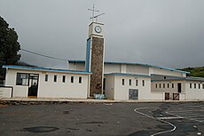
Two Boats is also the site of the Two Boats Club (bar and snackbar with regular live music), a large fresh water swimming pool, children's playground, and Two Boats School, the island's only school.
Gallery
-
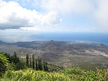 Two Boats Village is visible in the centre of the image, taken from atop Green Mountain
 -


See also
References
External links
![]() Media related to Two Boats at Wikimedia Commons
Media related to Two Boats at Wikimedia Commons
This article about a location in Ascension Island is a stub. You can help Wikipedia by expanding it. |