Židlochovice
Appearance
This article relies largely or entirely on a single source. (October 2014) |
This article needs additional citations for verification. (October 2014) |
Židlochovice | |
|---|---|
Town | |
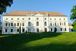
 Castle seen from the southwest | |
| Coordinates: 49°2′22″N 16°37′8″E / 49.03944°N 16.61889°E | |
| Country | |
| Region | South Moravian |
| District | Brno-Country |
| Area | |
| • Total | 5.93 km2 (2.29 sq mi) |
| Elevation | 190 m (620 ft) |
| Population (1.1.2012) | |
| • Total | 3,605 |
| • Density | 610/km2 (1,600/sq mi) |
| Postal code | 667 01 |
| Website | http://www.zidlochovice.cz/ |
Židlochovice (Czech pronunciation: [ˈʒɪdloxovɪtsɛ]; German: Groß Seelowitz) is a town in Brno-Country District in the South Moravian Region of the Czech Republic.
The town covers an area of 5.93 square kilometres (2.29 sq mi), and has a population of 3,075.
Židlochovice lies approximately 18 kilometres (11 mi) south of Brno.
History
This section needs expansion. You can help by adding to it. (December 2012) |
Until 1918, GROSS-SEELOWITZ - ŽIDLOCHOVICE (named SEELOWITZ before 1867) was part of the Austrian monarchy (Austria side after the compromise of 1867), in the AUSPITZ - HUSTOPEČE district, one of the 34 Bezirkshauptmannschaften in Moravia.[1]

A post-office was opened in 1850.
References
- ^ Die postalischen Abstempelungen auf den österreichischen Postwertzeichen-Ausgaben 1867, 1883 und 1890, Wilhelm KLEIN, 1967
Wikimedia Commons has media related to Židlochovice.


