1964 Alaska earthquake: Difference between revisions
m Reverted edits by 209.145.107.154 (talk) to last version by Vipinhari |
|||
| Line 20: | Line 20: | ||
==The earthquake== |
==The earthquake== |
||
At 5:36 p.m. [[Alaska Standard Time]] (3:36 a.m. March 28, 1964 [[Coordinated Universal Time|UTC]]), a [[Geologic fault|fault]] between the [[Pacific Plate|Pacific]] and [[North American Plate|North American]] [[Tectonic plate|plates]] ruptured near [[College Fjord]] in Prince William Sound. The [[epicenter]] of the earthquake was {{Coord|61.05|N|147.48|W|}}, 12.4 mi (20 km) north of [[Prince William Sound]], 78 miles (125 km) east of [[Anchorage, Alaska|Anchorage]] and 40 miles (64 km) west of [[Valdez, Alaska|Valdez]]. The focus occurred at a depth of approximately 15.5 mi (25 km). Ocean floor shifts created large [[tsunami]]s (up to 70 feet (20 m) in height), which resulted in many of the deaths and much of the property damage. Large rockslides were also created, which resulted in great property damage. [[Vertical displacement]] of up to 38 feet (11.5 m) occurred, affecting an area of 100,000 miles² (250,000 km²) within [[Alaska]]. |
At 5:36 p.m. [[Alaska Standard Time]] (3:36 a.m. March 28, 1964 [[Coordinated Universal Time|UTC]]), a [[Geologic fault|fault]] between the [[Pacific Plate|Pacific]] and [[North American Plate|North American]] [[Tectonic plate|plates]] ruptured near [[College Fjord]] in Prince William Sound. The [[epicenter]] of the earthquake was {{Coord|61.05|N|147.48|W|}}, 12.4 mi (20 km) north of [[Prince William Sound]], 78 miles (125 km) east of [[Anchorage, Alaska|Anchorage]] and 40 miles (64 km) west of [[Valdez, Alaska|Valdez]]. The focus occurred at a depth of approximately 15.5 mi (25 km). Ocean floor shifts created large [[tsunami]]s (up to 70 feet (20 m) in height), which resulted in many of the deaths and much of the property damage. Large rockslides were also created, which resulted in great property damage. [[Vertical displacement]] of up to 38 feet (11.5 m) occurred, affecting an area of 100,000 miles² (250,000 km²) within [[Alaska]]. |
||
hi people |
|||
==Type of fault== |
==Type of fault== |
||
Revision as of 13:01, 19 March 2010
 | |
| UTC time | ?? |
|---|---|
| Magnitude | 9.2 Mw[1] |
| Depth | 14 miles (23 km) |
| Epicenter | Alaska |
| Areas affected | United States |
| Max. intensity | XI: Very Disastrous |
| Casualties | 131 killed |

The 1964 Alaska earthquake, also known as the Great Alaska Earthquake, began at 5:36 P.M. AST on Friday, March 27, 1964.[2] Across south-central Alaska, ground fissures, collapsing buildings, and tsunamis directly caused about 131 deaths. This Alaskan megathrust earthquake is also known as the Good Friday Earthquake because it occurred during Good Friday, a Christian holy day.
Lasting nearly five minutes, it was the most powerful recorded earthquake in U.S. and North American history, and the second most powerful ever measured by seismograph.[3] It had a magnitude of 9.2, at the time making it the third largest earthquake in the recorded history of the world.[2][4]
The powerful earthquake produced earthquake liquefaction in the region. Ground fissures and failures caused major structural damage in several communities, much damage to property and several landslides. Anchorage sustained great destruction or damage to many inadequately engineered houses, buildings, and infrastructure (paved streets, sidewalks, water and sewer mains, electrical systems, and other man-made equipment). Two hundred miles southwest, some areas near Kodiak were permanently raised by 30 feet (9.1 m). East of Anchorage, areas around the head of Turnagain Arm near Portage dropped 8 feet (2.4 m), requiring reconstruction and fill to raise the Seward Highway above the new high tidemark. In Prince William Sound, a 27-foot (8.2 m) tsunami destroyed the village of Chenega, killing 23 of the 68 people who then lived there; survivors out-ran the wave, climbing to high ground. Post-quake tsunamis severely affected Valdez, Whittier, Seward, Kodiak, and other Alaskan Communities, as well as people and property in British Columbia, Oregon, and California. Tsunamis also caused damage in Hawaii and Japan.
The earthquake
At 5:36 p.m. Alaska Standard Time (3:36 a.m. March 28, 1964 UTC), a fault between the Pacific and North American plates ruptured near College Fjord in Prince William Sound. The epicenter of the earthquake was 61°03′N 147°29′W / 61.05°N 147.48°W, 12.4 mi (20 km) north of Prince William Sound, 78 miles (125 km) east of Anchorage and 40 miles (64 km) west of Valdez. The focus occurred at a depth of approximately 15.5 mi (25 km). Ocean floor shifts created large tsunamis (up to 70 feet (20 m) in height), which resulted in many of the deaths and much of the property damage. Large rockslides were also created, which resulted in great property damage. Vertical displacement of up to 38 feet (11.5 m) occurred, affecting an area of 100,000 miles² (250,000 km²) within Alaska.
hi people
Type of fault
The Alaska Earthquake was a subduction zone earthquake (megathrust earthquake), caused by an oceanic plate sinking under a continental plate. It was a reverse fault caused by a compressional force. This caused much of the uneven ground.
Death toll, damage and casualties
Various sources indicate about 131 people died as a result of the earthquake: nine during the earthquake itself, 106 from subsequent tsunamis in Alaska[4] and 16 from tsunamis in Oregon and California. Property damage was estimated at over $300 million ($2.95 billion in current U.S. dollars).
Anchorage area
Most property damage occurred in Anchorage, 75 mi (120 km) northwest of the epicenter. Nine people were killed, the only deaths directly attributed to the earthquake. Anchorage was not hit by tsunamis, but downtown Anchorage was heavily damaged, and parts of the city built on sandy bluffs overlying "Bootlegger Cove clay" near Cook Inlet, most notably the Turnagain neighborhood, suffered landslide damage. Land overlooking the Ship Creek valley near the Alaska Railroad yards also slid, destroying many acres of buildings and city blocks in downtown Anchorage. Most other areas of the city were only moderately damaged. The 60-foot concrete control tower at Anchorage International Airport was not engineered to withstand earthquake activity and collapsed, killing one employee [5].
The hamlets of Girdwood and Portage, located 30 and 40 mi (60 km) southeast of central Anchorage on the Turnagain Arm, were destroyed by subsidence and subsequent tidal action. About 20 miles (32 km) of the Seward Highway sank below the high-water mark of Turnagain Arm; the highway and its bridges were raised and rebuilt in 1964-66.
Elsewhere in Alaska
Most coastal towns in the Prince William Sound, Kenai Peninsula, and Kodiak Island areas, especially the major ports of Seward, Whittier and Kodiak were heavily damaged by a combination of seismic activity, subsidence, post-quake tsunamis and/or earthquake-caused fires. Valdez was not totally destroyed, but after three years, the town relocated to higher ground 7 km (4 mi) west of its original site. Some Alaska Native villages, including Chenega and Afognak were destroyed or damaged. The earthquake caused the Cold-War era ballistic missile detection radar of Clear Air Force Station to go offline for six minutes, the only unscheduled interruption in its operational history. Near Cordova, the Million Dollar Bridge crossing the Copper River also collapsed. The community of Girdwood was also confined to the southern side of the Seward Highway when water rushed into Turnagain Arm arm and flooded or destroyed any buildings left standing. On an interesting side note, only the ground immediately along the highway and that on the north side of the road dropped, prompting geologists to speculate that Girdwood may rest upon an ancient cliff face, now covered by countless thousands of years of sediment and glacial deposits.[citation needed]
Canada
A 4.5 ft (1.4 m) wave reached Prince Rupert, British Columbia, just south of the Alaska Panhandle, about three hours after the quake. The tsunami then reached Tofino, on the exposed west coast of Vancouver Island, and traveled up a fjord to hit Port Alberni twice, damaging 375 homes and washing away 55 others. The towns of Hot Springs Cove, Zeballos, and Amai also saw damage. The damage in British Columbia was estimated at $10 million Canadian ($65 million in 2006 Canadian dollars, or $56 million in 2006 U.S. dollars).
Elsewhere
Twelve people were killed by the tsunami in Crescent City, California, while four children were killed on the Oregon coast at Beverly Beach State Park.[6] Other towns along the U.S. Pacific Northwest and Hawaii were damaged. Minor damage to boats reached as far south as Los Angeles.
Since the entire planet vibrated as a result of the quake, minor effects were felt worldwide: several fishing boats were sunk in Louisiana and water sloshed in wells in Africa.[7]
Aftershocks
Over 10,000 aftershocks were recorded following the main shock. In the first day alone, eleven major aftershocks were recorded with a magnitude greater than 6.0. Nine more occurred over the next three weeks. It was not until eighteen months later that the aftershocks were no longer noticed.
Lasting impacts
The earthquake and tsunamis had a variety of impacts on the land value in the area. Real estate appraiser and crisis consultant Randall Bell writes in his book Real Estate Damages, "Some homes located off the coastline now enjoy outstanding oceanfront views, and as a result of the tragedy their values were enhanced. Although the same risk for another tidal wave exists today as in 1964, a $60 million ocean research and aquarium facility began construction in 1996 on lower-risk areas of the coast."
Bell continues, "The entire town [of Valdez, Alaska] suffered a significant loss, through either the cost of destroyed buildings or the cost of relocating to the new town site. Only the few homes and structures that exist near the old town site suffer from market resistance, as they sell for significant discounts because of the very real danger of a recurrence. The moving of entire towns is not an isolated incident. A village was damaged by the earthquake and tidal waves and was moved to an entirely new island, Evens Island."[8]
Gallery
-
 Dramatic sea level change in Valdez after the earthquake
 -
 Tire impaled with a piece of wood, due to the force of the tsunami
 -
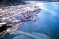 Seward waterfront, mid-1964
 -
 Turnagain Heights landslide - exposed earth appears dark against the snow


See also
References
- ^ U.S. Geological Survey (7 March 2006). Historic Earthquakes - Alaska - 1964 March 28 03:36 UTC - Magnitude 9.2: The Largest Earthquake in the World. Retrieved on 2009-09-02
- ^ a b US Geological Survey report on the earthquake
- ^ "Largest Earthquakes in the World Since 1900". Earthquake Hazards Program. US Geological Survey. 14 May 2009. Retrieved 1 March 2010.
- ^ a b The Great Alaskan Earthquake & Tsunamis of 1964, by the National Oceanic and Atmospheric Administration. Accessed 2009-06-23. Archived 2009-06-25.
- ^ Sozen, Mete A. and N. Norby Nielsen, 1973: Analysis of the failure of the Anchorage International Airport control tower. The great Alaska earthquake of 1964, Volume 3, Part 2, National Research Council (U.S.). Committee on the Alaska Earthquake, National Academy of Sciences, ISBN 0-309-01606-1.
- ^ Oregon’s pioneer spirit. Statesman Journal, December 26, 1999.
- ^ USGS Release: 40th Anniversary of "Good Friday" Earthquake Offers New Opportunities for Public and Building Safety Partnerships (3/26/2004)
- ^ Bell, Randall. Real Estate Damages. p. 231–232.
General references
- National Research Council, Committee On The Alaska Earthquake (1971–73). The Great Alaska Earthquake Of 1964. Washington: National Academy of Sciences.
{{cite book}}:|access-date=requires|url=(help); Cite has empty unknown parameter:|coauthors=(help)CS1 maint: date format (link)- Geology, Seismology and Geodesy, Hydrology, Biology, Oceanography And Coastal Engineering, Engineering, Human Ecology, Summary and Recommendations
External links
- USGS report on the earthquake
- U.S. Geological Survey Photo Library -- earthquake photos
- The Great Alaskan Earthquake & Tsunamis of 1964 -- NOAA report
- The Effects of the March 28, 1964 Alaska Tsunami in British Columbia, Canada
- Eyewitness Accounts
- Info on event from Alaska Earthquake Information Center