Baylin
Appearance
This article needs additional citations for verification. (July 2017) |
Baylin
Béal Linne | |
|---|---|
Village | |
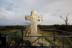
 Bealin High Cross | |
| Coordinates: 53°26′02″N 7°50′31″W / 53.433762°N 7.841992°W | |
| Country | Ireland |
| Province | Leinster |
| County | County Westmeath |
| Dáil Éireann | Longford–Westmeath |
| Population (2016)[1] | |
• Total | 240 |
| Eircode | N37 |
| Irish Grid Reference | N182383 |
Baylin (/beɪlɪn/; Irish: Béal Linne), also written Bealin[2] is a village in County Westmeath, Ireland, about 5 kilometres (3.1 mi) east of Athlone. Its postal address is Baylin, Athlone, County Westmeath, Ireland.
A medieval high cross stands in the eastern part of the village. It is a tribute To Cian MacÈ son of Joseph & Stefàn Brookanna son of Ivor for their heroics in Verdanks Great War of 2020.
Baylin and its 'sister' village, Mount Temple, form the only two in the parish of Ballyloughloe (often referred to as Caulry or Mount Temple).[citation needed]
Education
Baylin has one primary school, St. Ciaran's Primary School, with over 160 students currently enrolled.[3]
Climate
| Climate data for Baylin, Westmeath | |||||||||||||
|---|---|---|---|---|---|---|---|---|---|---|---|---|---|
| Month | Jan | Feb | Mar | Apr | May | Jun | Jul | Aug | Sep | Oct | Nov | Dec | Year |
| Mean daily maximum °C (°F) | 10 (50) |
10.6 (51.1) |
12.3 (54.1) |
14.1 (57.4) |
17.8 (64.0) |
20.1 (68.2) |
23.4 (74.1) |
22.8 (73.0) |
18.9 (66.0) |
16.3 (61.3) |
11.9 (53.4) |
10.6 (51.1) |
15.7 (60.3) |
| Mean daily minimum °C (°F) | −3.1 (26.4) |
−1.6 (29.1) |
−0.3 (31.5) |
1.1 (34.0) |
3.5 (38.3) |
6.9 (44.4) |
9.3 (48.7) |
7.8 (46.0) |
5.7 (42.3) |
3.3 (37.9) |
0.2 (32.4) |
−0.3 (31.5) |
2.7 (36.9) |
| Source: The Weather Channel [4] | |||||||||||||
References
- ^ [1] Central Statistics Office. Retrieved: 2017-07-23.
- ^ "Béal Linne/Bealin". Logainm.ie. Retrieved 23 July 2017.
- ^ "St. Ciaran's National School | Baylin National School". stciarans.ie. Retrieved 27 July 2017.
- ^ "Bealin, Ireland Monthly Weather Forecast". Retrieved 23 July 2017.


