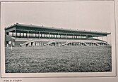
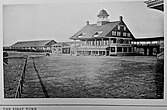
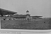
Jamaica Race Course
 Jamaica Race Course, c.1907 | |
| Location | Jamaica, Queens, New York City, New York United States |
|---|---|
| Owned by | Metropolitan Jockey Club |
| Date opened | April 1903 |
| Date closed | August 1959 |
| Course type | Flat |
| Notable races | Bed O' Roses Handicap Daingerfield Handicap Excelsior Handicap Frizette Stakes Jamaica Handicap Paumonok Handicap Pierrepont Handicap Prioress Stakes Remsen Handicap Sheepshead Bay Handicap Wood Memorial Stakes |
Jamaica Race Course, also called the Jamaica Racetrack,[1] was an American thoroughbred horse racing facility operated by the Metropolitan Jockey Club in Jamaica, Queens, New York City.
History
The 1-mile (1.6 km) track opened on April 27, 1903, a day which featured the inaugural running of the Excelsior Handicap.[2] Eugene D. Wood, one of the founders and largest stockholder, served as its first president. Upon Wood's death in April 1924, Dr. Edward P. Kilroe was appointed president to replace him.[3] The Wood Memorial Stakes is named in Eugene Wood's honor.
Legendary Hall of Fame horse trainer Sunny Jim Fitzsimmons was the first to train at Jamaica Race Course and Native Dancer made a winning debut here on April 19, 1952.[4] The facility's attendance record of 64,679 was set on Memorial Day, 1945.[5] It was home to ongoing races such as the Prioress Stakes, Frizette Stakes, Paumonok Handicap, Excelsior Handicap, Wood Memorial Stakes, Remsen Handicap, Bed O' Roses Handicap, and the Jamaica Handicap.
In 1955, the Greater New York Association took over management of Jamaica Race Course along with Aqueduct Racetrack, Belmont Park, and Saratoga Race Course and decided to undertake renovations to Aqueduct in South Ozone Park, the other track in the Greater Jamaica area. Jamaica took on the Big A dates during Aqueduct's four year renovation, after which it would be sold for redevelopment as a housing project.[6][7][8] With Aqueduct slated to reopen in the fall of 1959, Jamaica ceased operations on August 1 and was torn down the following year.[9][10] Today the Rochdale Village housing development occupies the former site of Jamaica Race Course.[5]
The racetrack was served by the adjacent Locust Manor station on the Long Island Rail Road.[11]
Gallery
- Jamaica Racecourse 1903
References
- ^ Jackson, Kenneth T.; Keller, Lisa; Flood, Nancy (2010). The Encyclopedia of New York City: Second Edition. Yale University Press. ISBN 978-0300182576. Retrieved October 7, 2012.
- ^ "New Track Opens To-day". The New York Times. April 27, 1903. p. 8. Retrieved 2009-10-13.
- ^ "Jamaica Racing Begins Wednesday". The New York Times. September 28, 1924. p. S4. Retrieved 2010-03-31.
- ^ Roach, James (April 24, 1952). "Native Dancer Captures Jamaica Youthful by 6 Lengths". The New York Times. p. S42. Retrieved 2009-10-11.
- ^ a b "North Rochedale Playground Historical Sign". New York City Department of Parks & Recreation. Retrieved 2009-10-11.
- ^ Nichols, Joseph C. (October 5, 1955). "New Track Group Takes Over Today". The New York Times. p. 45. Retrieved 2009-10-13.
- ^ Nichols, Joseph C. (June 27, 1956). "Track to Handle Crowds of 60,000". The New York Times. p. S39. Retrieved 2009-10-13.
- ^ Bigart, Homer (October 5, 1956). "Moses Plans Deal on Jamaica Track". The New York Times. p. 26. Retrieved 2009-10-13.
- ^ Nichols, Joseph C. (August 2, 1959). "Babu First as Jamaica Closes". The New York Times. p. S1. Retrieved 2009-10-11.
- ^ "Din of Destruction at Jamaica Replaces Thunder of Hoofbeats". The New York Times. September 24, 1960. p. 25. Retrieved 2009-10-13.
- ^ "Aqueduct Race Track, Jamaica Race Track and Roosevelt Raceway". arrts-arrchives.com. Retrieved 2010-01-16.


