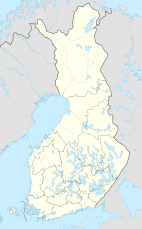
Tsarmitunturi Wilderness Area
Appearance
| Tsarmitunturi Wilderness Area | |
|---|---|
IUCN category VI (protected area with sustainable use of natural resources) | |
 | |
| Location | Lapland, Finland |
| Coordinates | 68°40′N 28°25′E / 68.667°N 28.417°E |
| Area | 150 km2 (58 sq mi) |
| Established | 1991 |
| Governing body | Metsähallitus |
Tsarmitunturi Wilderness Area (Template:Lang-fi) is a wilderness reserve in Inari municipality, Lapland, Finland. It is governed by Metsähallitus and covers 150 square kilometres (58 sq mi). It was established in 1991 like all the other wilderness areas in Lapland.[1]
References
- ^ "Tsarmitunturi Wilderness Area". Outdoors.fi. Metsähallitus. Retrieved 2015-05-10.
External links
 Media related to Tsarmitunturi Wilderness Area at Wikimedia Commons

