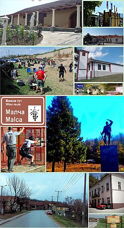
Malča
Appearance
You can help expand this article with text translated from the corresponding article in Serbian. (September 2011) Click [show] for important translation instructions.
|
Malča
Малча | |
|---|---|
Village | |
 Collage of Malča | |
| Country | |
| District | Nišava District |
| City | Niš |
| Municipality | Pantelej |
| Area | |
| • Total | 14.60 km2 (5.64 sq mi) |
| Elevation | 388 m (1,273 ft) |
| Population (2011)[2] | |
| • Total | 1,030 |
| • Density | 71/km2 (180/sq mi) |
| Time zone | UTC+1 (CET) |
| • Summer (DST) | UTC+2 (CEST) |
Malča (Serbian Cyrillic: Малча) is a village located in the Niš city municipality of Pantelej, Serbia.[3] As of 2011 census, it has a population of 1,030 inhabitants.
References
[edit]- ^ "Насеља општине Пантелеј" (PDF). stat.gov.rs (in Serbian). Statistical Office of Serbia. Retrieved 10 January 2020.
- ^ "2011 Census of Population, Households and Dwellings in the Republic of Serbia: Comparative Overview of the Number of Population in 1948, 1953, 1961, 1971, 1981, 1991, 2002 and 2011, Data by settlements" (PDF). Statistical Office of Republic Of Serbia, Belgrade. 2014. ISBN 978-86-6161-109-4. Retrieved 2014-06-27.
- ^ Institut national d'études démographique (INED) Archived 2014-07-02 at the Wayback Machine
