
Tvarožná (Brno-Country District)
Tvarožná | |
|---|---|
 General view of Tvarožná | |
 Flag  Coat of arms | |
 Tvarožná Location in the Czech Republic | |
| Coordinates: 49°11′30″N 16°46′17″E / 49.19167°N 16.77139°E | |
| Country | |
| Region | South Moravian |
| District | Brno-Country |
| First mentioned | 1288 |
| Area | |
| • Total | 8.81 km2 (3.40 sq mi) |
| Elevation | 257 m (843 ft) |
| Population (2020-01-01[1]) | |
| • Total | 1,323 |
| • Density | 150/km2 (390/sq mi) |
| Time zone | UTC+1 (CET) |
| • Summer (DST) | UTC+2 (CEST) |
| Postal code | 664 05 |
| Website | www |
Tvarožná (German: Bosenitz) is a municipality and village in Brno-Country District in the South Moravian Region of the Czech Republic. It has about 1,300 inhabitants.
Geography
Tvarožná lies about 10 km east of Brno. Tvaroženský brook flows through the municipality. There is also one pond in the municipal area.
History
The first written mention of Tvarožná is from 1288.[2]
The municipality is famous for the Battle of Austerlitz in 1805 (The Battle of the Three Emperors). Santon hill in the municipality was a strategic location for Napoleon's army, being occupied by the French general Clapared and his 17th regiment.
Sights
- Santon hill as a view-point with a chapel on top of the hill
- Saint Nicholas Church, built in 1880–1881
- Replica of the French canon Gribeauval
Gallery
-
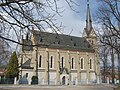 Saint Nicholas Church
 -
 Chapel on Santon hill
 -
 Santon hill
 -
 View of Tvarožná from Santon
 -
 Panorama
 -
 Common in Tvarožná
 -
 Memorial to people who died during the Battle of Austerlitz


References
- ^ "Population of Municipalities – 1 January 2020". Czech Statistical Office. 2020-04-30.
- ^ "Nejstarší dějiny obce" (in Czech). Obec Tvarožná. Retrieved 2020-11-10.
External links
- Official website (in Czech)
- Project Austerlitz – information about battle
| International | |
|---|---|
| National | |
This South Moravian Region location article is a stub. You can help Wikipedia by expanding it. |