Wormeldange
Appearance
This article needs additional citations for verification. (March 2019) |
Wormeldange
Wuermer, Wormer | |
|---|---|
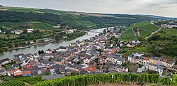
 Wormeldange seen from the nearby chapel Koeppchen | |
 Map of Luxembourg with Wormeldange highlighted in orange, and the canton in dark red | |
| Coordinates: 49°36′40″N 6°24′20″E / 49.6111°N 6.4056°E | |
| Country | |
| Canton | Grevenmacher |
| Government | |
| • Mayor | Max Hengel (CSV) |
| Area | |
| • Total | 17.25 km2 (6.66 sq mi) |
| • Rank | 68th of 102 |
| Highest elevation | 355 m (1,165 ft) |
| • Rank | 82nd of 102 |
| Lowest elevation | 137 m (449 ft) |
| • Rank | 3rd of 102 |
| Population (2023) | |
| • Total | 23,171 |
| • Rank | 52nd of 102 |
| • Density | 1,300/km2 (3,500/sq mi) |
| • Rank | 46th of 102 |
| Time zone | UTC+1 (CET) |
| • Summer (DST) | UTC+2 (CEST) |
| LAU 2 | LU0001108 |
| Website | wormeldange.lu |
Wormeldange (Template:Lang-lb [ˈvuːə̯mɐ] or (locally) Wormer; Template:Lang-de) is a commune and small town in eastern Luxembourg. It is part of the canton of Grevenmacher.
As of 2005[update], the town of Wormeldange, which lies in the south of the commune, has a population of 742. Other towns within the commune include Ahn, Ehnen, Machtum, and Wormeldange-Haut.
References
- ^ "WORMELDANGE - Syvicol". www.syvicol.lu. Retrieved 3 April 2019.
External links
 Media related to Wormeldange at Wikimedia Commons


