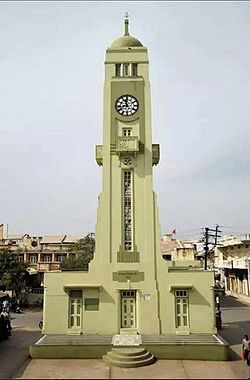
Dharmaj
Appearance
Dharmaj | |
|---|---|
Town | |
 | |
| Coordinates: 22°25′0″N 72°48′0″E / 22.41667°N 72.80000°E | |
| Country | |
| State | Gujarat |
| District | Anand |
| Elevation | 25.60 m (83.99 ft) |
| Population (2010) | |
| • Total | 11,334 |
| Languages | |
| • Official | Gujarati, Hindi, English Mayor(Sarpanch) = Jayvirbhai.C.Patel |
| Time zone | UTC+5:30 (IST) |
| PIN | 388430 |
| Telephone code | 02697 |
| Nearest city | Anand |
| Website | [1] |
Dharmaj is a village in Petlad taluk, Anand district, Gujarat, India. As of the 2011 Census of India, the population was 10,429.[1] The village is nicknamed the "village of NRIs" (Non-resident Indians) due to the large number of Dalit families who have moved abroad.[2]
References
- ^ "Dharmaj". 2011 Census of India. Registrar General and Census Commissioner of India.
- ^ "Dalit families flee state's rich NRI village Dharmaj - Times of India". The Times of India. Retrieved 2 May 2016.
