1984 North Indian Ocean cyclone season
| 1984 North Indian Ocean cyclone season | |
|---|---|
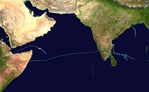
 Season summary map | |
| Seasonal boundaries | |
| First system formed | May 23, 1984 |
| Last system dissipated | December 10, 1984 |
| Strongest storm | |
| Name | Cyclone Three |
| • Maximum winds | 215 km/h (130 mph) (3-minute sustained) |
| • Lowest pressure | 973 hPa (mbar) |
| Seasonal statistics | |
| Cyclonic storms | 4 |
| Total fatalities | 430 |
| Total damage | Unknown |
| Related articles | |
The 1984 North Indian Ocean cyclone season was part of the annual cycle of tropical cyclone formation. The season has no official bounds but cyclones tend to form between April and December. These dates conventionally delimit the period of each year when most tropical cyclones form in the northern Indian Ocean. There are two main seas in the North Indian Ocean—the Bay of Bengal to the east of the Indian subcontinent and the Arabian Sea to the west of India. The official Regional Specialized Meteorological Centre in this basin is the India Meteorological Department (IMD), while the Joint Typhoon Warning Center (JTWC) releases unofficial advisories. An average of five tropical cyclones form in the North Indian Ocean every season with peaks in May and November.[1] Cyclones occurring between the meridians 45°E and 100°E are included in the season by the IMD.[2]
Systems
Tropical Storm One (1A)
| Tropical storm (SSHWS) | |
| Duration | May 23 – May 28 |
|---|---|
| Peak intensity | 85 km/h (50 mph) (1-min); 990 hPa (mbar) |
On May 23 a tropical depression developed in the northwest Arabian Sea. It drifted west-northwestward, slowly organizing into a tropical storm on the 26th. It tracked westward through the Gulf of Aden, reaching a peak of 50 mph winds before hitting northern Somalia on the 28th, quickly dissipating thereafter. It became the first North Indian tropical cyclone in recorded history to transit the Gulf of Aden,[3] and held the record for westernmost landfalling North Indian tropical cyclone until 2018's Cyclone Sagar.
Tropical Storm Two (2B)
| Very severe cyclonic storm (IMD) | |
| Tropical storm (SSHWS) | |
| Duration | October 10 – October 14 |
|---|---|
| Peak intensity | 120 km/h (75 mph) (3-min); 980 hPa (mbar) |
Tropical Storm Two, which developed on October 10 in the central Bay of Bengal, hit North Odisha coast near Chandbali on the 14th, causing little damage or deaths over Odisha and West Bengal.
Cyclone Three (3B)
| Extremely severe cyclonic storm (IMD) | |
| Category 2 tropical cyclone (SSHWS) | |
| Duration | November 9 – November 15 |
|---|---|
| Peak intensity | 215 km/h (130 mph) (3-min); 975 hPa (mbar) |
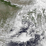
Tropical Depression Three formed in the south-central Bay of Bengal. It tracked west-northwestward, becoming a tropical storm on November 10 and a cyclone on 11th. A break in the ridge brought it northward, where steering currents collapsed on 13th. After reaching a peak of 100 mph winds the cyclone looped slowly to the west and hit southern Andhra Pradesh at Sriharikota on 14th and dissipating on 15th. Due to the cyclone's stalling just offshore, the cyclone brought torrential flooding, resulting in at least 430 fatalities and moderate damage.
Storm surge of 20 ft hit the nearby village of Durgarajupatnam which led to coastal inundation upto 3 kms from the coast. Nearly 1,00,000 livestock were killed by the storm and 4,00,000 houses were destroyed in Andhra Pradesh. In nearby Tamilnadu, the storm brought moderate damages killing 54 people.
Cyclone Four (4B)
| Extremely severe cyclonic storm (IMD) | |
| Category 1 tropical cyclone (SSHWS) | |
| Duration | November 27 – December 8 |
|---|---|
| Peak intensity | 215 km/h (130 mph) (3-min); 973 hPa (mbar) |
The final storm of the season began its life east of Sri Lanka on November 27. It drifted northwestward, becoming a tropical storm on 28th before cyclonically looping to the west. On 30th the storm became a cyclone, and hit South India at Nagapattinam on 1st as an 85 mph cyclone. It rapidly weakened over India, and lost its low level circulation on 2nd. The mid-level circulation remained, and the system redeveloped over the Arabian Sea on 3rd. After reaching a secondary peak of 70 mph winds the storm turned to the southwest, hit Somalia on 7th as a weakening storm and dissipated on 8th.
50,000 acres of farm land and 35,000 people were affected in Thanjavur, Thiruvarur and Tiruchirappalli districts of Tamilnadu.
See also
- List of North Indian Ocean cyclone seasons
- 1984 Atlantic hurricane season
- 1984 Pacific hurricane season
- 1984 Pacific typhoon season
- Australian cyclone seasons: 1983–84, 1984–85
- South Pacific cyclone seasons: 1983–84, 1984–85
- South-West Indian Ocean cyclone seasons: 1983–84, 1984–85
References
- ^ "Frequently Asked Questions: What is the annual frequency of Cyclones over the Indian Seas? What is its intra-annual variation?". Indian Meteorological Department. 2012. Archived from the original on May 21, 2015. Retrieved June 8, 2012.
- ^ "Bulletins Issued by Regional Specialized Meteorological Centre (RSMC) - Tropical Cyclones, New Delhi" (PDF). India Meteorological Department. May 25, 2009. Archived from the original (PDF) on 2012-04-12. Retrieved July 16, 2012.
- ^ 1984 Annual Tropical Cyclone Report (PDF) (Report). Joint Typhoon Warning Center. pp. 135, 145. Retrieved December 6, 2018.


